VTBS — Bangkok/ Suvarnabhumi International Airport
VTBS AD 2.1 AERODROME LOCATION INDICATOR AND NAME
VTBS — Bangkok/ Suvarnabhumi International Airport
VTBS AD 2.2 AERODROME GEOGRAPHICAL AND ADMINISTRATIVE DATA
| 1 |
ARP coordinates and site at AD |
134109N
1004456E
Midpoint between taxiways G, H, H2 and H3 |
| 2 |
Direction and distance from (city) | 25 km East of Bangkok |
| 3 |
Elevation/Reference temperature | 8 ft (2 m) / 32.4°C |
| 4 | Geoid undulation at AD ELEV PSN | -94 ft (-29 m) |
| 5 |
MAG VAR/Annual change | 0° 42' W (2025) / 0° 2' E |
| 6 |
AD Administration, address, telephone, |
999 Moo 1 Nong Prue, Bangphli, Samut Prakan 10540, Thailand Tel: +662 132 1888 Fax: +662 132 1889 URL: https://suvarnabhumi.airportthai.co.th AFS: VTBSYDYX |
| 7 |
Types of traffic permitted (IFR/VFR) | IFR / Authorized VFR |
| 8 |
Remarks | Operator: Airports of Thailand Public Company Limited (AOT) |
VTBS AD 2.3 OPERATIONAL HOURS
| 1 |
Aerodrome operator | H24 |
| 2 |
Customs and immigration |
H24 |
| 3 |
Health and sanitation | H24 |
| 4 |
AIS Briefing Office | H24 |
| 5 |
ATS Reporting Office (ARO) | H24 |
| 6 |
MET Briefing Office | H24 |
| 7 |
ATS | H24 |
| 8 |
Fuelling | H24 |
| 9 |
Handling | H24 |
| 10 |
Security | H24 |
| 11 |
De-icing |
NIL |
| 12 |
Remarks |
AIS Briefing Office and ATS Reporting Office (ARO): |
VTBS AD 2.4 HANDLING SERVICES AND FACILITIES
| 1 |
Cargo-handling facilities | Available from Thai Airways International Plc.and WFS-PG Cargo Co., Ltd. (BFS Cargo) |
| 2 |
Fuel/oil types | Jet A1 |
| 3 |
Fuelling facilities/capacity |
|
| 4 |
De-icing facilities |
NIL |
| 5 |
Hangar space for visiting aircraft | Limited, operated by Thai Airways International Plc. For Hangar space, please contact: Mrs. Apicha Runglapho Administrative Secretary,SBIA MRO Operations Department E-mail: [email protected] Tel: +662 137 5031 |
| 6 |
Repair facilities for visiting aircraft |
Major and minor repair available from Thai Airways International Plc. and line maintenance from International Airlines Technical Pool. |
| 7 |
Remarks |
The Airport has provided ground handling agents as following:
|
VTBS AD 2.5 PASSENGER FACILITIES
| 1 |
Hotels | At AD and in the city. |
| 2 |
Restaurants | At AD and in the city. |
| 3 |
Transportation | Airport Rail Link, buses, taxis and car hire from the AD. |
| 4 |
Medical facilities |
Medical clinic which provides first aid and emergency response at AD is open 24 hours. Emergency number is +662 132 7777. |
| 5 |
Bank and Post Office | At AD. |
| 6 |
Tourist Office | At AD. |
| 7 |
Remarks |
For further information visit Internet address : |
VTBS AD 2.6 RESCUE AND FIRE FIGHTING SERVICES
| 1 |
AD category for fire fighting | Category 10 |
| 2 |
Rescue equipment | Adequately provided as recommended by ICAO |
| 3 |
Capability for removal of disabled aircraft |
Capable of handling all aircraft up to B744 dimensions & weight, operated by Thai Airways International Plc. |
| 4 |
Remarks |
For removal of disabled aircraft, please contact: Airside Operations Department |
VTBS AD 2.7 SEASONAL AVAILABILITY - CLEARING
| 1 |
Types of clearing equipment |
NIL |
| 2 |
Clearance priorities |
NIL |
| 3 |
Remarks | The AD is available all seasons. |
VTBS AD 2.8 APRONS, TAXIWAYS AND CHECK LOCATIONS/POSITIONS DATA
| 1 | Apron surface and strength |
Surface: Concrete Main Apron, East Apron and West Apron Strength: PCR 1360/R/D/W/T SAT-1 Apron Strength: PCR 1010/R/A/W/T | ||
| 2 | Taxiway width, surface and strength |
Minimum Width: 25 m Taxiways: B2, B3, B4, B5, B6, B7, B8, B9, B10, B11, B12 and B13 Taxiways: C, C1, C2, C8, C9 and C10 Taxiways: D1, D2, D3, D4, D5, D6, D7, D8 and D9 Taxiways: E, E1, E2, E3, E5, E6, E7, E8, E9, E10, E12, E13, E15, E17, E19 and E21 Taxilanes: T1, T2, T3, T4, T5, T10, T11, T12, T13 and T14 Surface: Asphalt Strength: PCR 1730/F/D/X/T
Taxiways: B1 Taxiways: D10 and D11Surface: Concrete Taxiways: J, J1, J2, J3 and J4 Taxiways: K Taxilanes: T18 and T19 Surface: Concrete Strength: PCR 900/R/A/W/T
Taxiways: D Surface: Asphalt Strength: PCR 1730/F/D/X/T Surface: Concrete Strength: PCR 1220/R/C/W/T | ||
| 3 |
Altimeter checkpoint location and elevation |
Location : At Apron | ||
| 4 |
VOR checkpoints |
NIL | ||
| 5 |
INS checkpoints |
See Aircraft Parking/Docking Chart - ICAO (Versos) for coordinates of aircraft stand. | ||
| 6 |
Remarks |
NIL | ||
VTBS AD 2.9 SURFACE MOVEMENT GUIDANCE AND CONTROL SYSTEM AND MARKINGS
| 1 |
Use of aircraft stand ID signs, TWY guidelines and visual docking/parking guidance system of aircraft stands |
Taxiing guidance signs at all intersections with TWY and RWY and at all holding positions. Guidelines at apron. Nose-in guidance at aircraft stands. |
| 2 |
RWY and TWY markings and LGT |
RWY: Designation, THR, TDZ, Centre line, edge and runway end marked and lighted. TWY: Centre line and edge marked and lighted. |
| 3 |
Stop bars |
Stop bars are installed at following locations: - Taxiway B1, B2, B3, B11, B12, B13 - Taxiway E1, E2, E3, E5, E10, E15, E17, E19, E21 |
| 4 |
Remarks | Intermediate holding positions are provided at some TWY/TWY intersections. |
VTBS AD 2.10 AERODROME OBSTACLES
|
In approach/TKOF areas |
In circling areas and at AD |
Remarks | |||
|---|---|---|---|---|---|
| 1 | 2 | 3 | |||
|
RWY/Area affected |
Obstacle type Elevation Markings/LGT |
Coordinates |
Obstacle type Elevation Markings/LGT |
Coordinates | |
| a | b | c | a | b | |
| 19/TKOF |
CCTV Pole |
133858.4N
1004457.3E
|
Antenna on top of Building 197.5 ft (60.2 m) |
134338.8N
1004633.5E
| |
| 19/TKOF |
CCTV Pole 20.8 ft (6.3 m) |
133900.5N
1004457.2E
|
Institute Building 203.9 ft (62.1 m) LGTD |
134339.2N
1004618.8E
| |
| 19/TKOF | Vegetation 41.1 ft (12.5 m) |
133849.6N
1004456.6E
| Communication Tower 153.0 ft (46.6 m) |
134104.1N
1004330.9E
| |
| 19/TKOF | Sub-distribution Building 23.4 ft (7.1 m) |
133858.4N
1004503.6E
|
Pole on top of 466.4 ft (142.1 m) LGTD |
134147.2N
1004458.5E
| |
| Antenna on top of East Apron Control Tower Building 171.5 ft (52.3 m) |
134124.0N
1004516.1E
| ||||
| Antenna on top of West Apron Control Tower Building 170.4 ft (51.9 m) |
134131.4N
1004446.5E
| ||||
| Antenna on top of Building 169.2 ft (51.6 m) |
134142.8N
1004511.2E
| ||||
|
Industrial Stack |
133957.3N
1004719.8E
| ||||
|
Industrial Stack 185.9 ft (56.7 m) marked |
133958.2N
1004720.1E
| ||||
|
Industrial Stack |
133955.8N
1004719.1E
| ||||
| Industrial Stack 169.3 ft (51.6 m) marked |
133954.7N
1004718.6E
| ||||
| Advertising Sign Board 178.2 ft (54.3 m) |
134123.9N
1004346.0E
| ||||
| Residential Building 165.2 ft (50.4 m) LGTD |
133753.4N
1004347.5E
| ||||
| Residential Building 158.8 ft (48.4 m) LGTD |
133802.8N
1004342.9E
| ||||
| Residential Building 158.1 ft (48.2 m) LGTD |
133803.4N
1004340.8E
|
NIL | |||
| Residential Building 157.3 ft (47.9 m) LGTD |
133805.4N
1004339.4E
| ||||
| Residential Building 157.7 ft (48.1 m) LGTD |
133807.7N
1004339.4E
| ||||
|
Residential Building 156.7 ft (47.8 m) LGTD |
133809.8N
1004339.5E
| ||||
| Residential Building 158.2 ft (48.2 m) LGTD |
133812.0N
1004340.1E
| ||||
| Residential Building 153.8 ft (46.9 m) LGTD |
134332.3N
1004618.1E
| ||||
| Terminal Building 170.7 ft (52.0 m) |
134127.1N
1004510.9E
| ||||
| Office Building 151.5 ft (46.2 m) LGTD |
134239.7N
1004530.1E
| ||||
| Office Building 162.4 ft (49.5 m) LGTD |
134227.1N
1004530.7E
| ||||
| Secondary Surveillance Radar (SSR) Tower Building 168.6 ft (51.4 m) LGTD |
134149.8N
1004615.7E
| ||||
| Primary Surveillance Radar (PSR) Tower Building 156.8 ft (47.8 m) |
134122.9N
1004613.2E
| ||||
| Surface Movement Radar (SMR) Tower Building 152.8 ft (46.6 m) |
134105.4N
1004433.6E
| ||||
| Residential Building 163.6 ft (49.9 m) LGTD |
133751.4N
1004358.0E
| ||||
| Residential Building 161.1 ft (49.1 m) LGTD |
133751.9N
1004356.0E
| ||||
| Residential Building 160.5 ft (48.9 m) LGTD |
133752.2N
1004353.8E
| ||||
| Residential Building 162.4 ft (49.5 m) LGTD |
133752.5N
1004351.8E
|
NIL | |||
| Residential Building 163.8 ft (49.9 m) LGTD |
133753.0N
1004349.6E
| ||||
| Terminal Building 170.7 ft (52.0 m) LGTD |
134127.5N
1004511.0E
| ||||
| Hangar Building 162.4 ft (49.5 m) LGTD |
134223.6N
1004539.4E
| ||||
| 02R/TKOF | Lighting Pole 34.8 ft (10.6 m) |
134258.3N
1004443.1E
| Institute Building 203.9 ft (62.1 m) LGTD |
134339.2N
1004618.8E
| |
| 02R/TKOF | High Mast Lighting Pole 116.2 ft (35.4 m) |
134335.4N
1004447.9E
| Communication Tower 153.0 ft (46.6 m) |
134104.1N
1004330.9E
| |
| 02R/TKOF | High Mast Lighting Pole 69.6 ft (21.2 m) |
134255.6N
1004449.9E
| Pole on top of Control Tower Building 466.4 ft (142.1 m) LGTD |
134147.2N
1004458.5E
| |
| 02R/TKOF | High Mast Lighting Pole 73.4 ft (22.4 m) |
134257.5N
1004448.4E
| Antenna on top of East Apron Control Tower Building 171.5 ft (52.3 m) |
134124.0N
1004516.1E
| |
| 02R/TKOF | High Mast Lighting Pole 87.5 ft (26.7 m) |
134303.8N
1004447.0E
| Antenna on top of West Apron Control Tower Building 170.4 ft (51.9 m) |
134131.4N
1004446.5E
| |
| 02R/TKOF | High Mast Lighting Pole 73.0 ft (22.2 m) |
134306.8N
1004447.6E
| Antenna on top of Building 169.2 ft (51.6 m) |
134142.8N
1004511.2E
| |
| 02R/TKOF | High Mast Lighting Pole 73.7 ft (22.5 m) |
134309.4N
1004447.8E
| Advertising Sign Board 178.2 ft (54.3 m) |
134123.9N
1004346.0E
| |
| 02R/TKOF | High Mast Lighting Pole 90.0 ft (27.4 m) |
134301.5N
1004444.2E
| Residential Building 157.7 ft (48.1 m) LGTD |
133807.7N
1004339.4E
| |
| 02R/TKOF | High Mast Lighting Pole 85.7 ft (26.1 m) |
134300.4N
1004447.0E
| Residential Building 156.7 ft (47.8 m) LGTD |
133809.8N
1004339.5E
| |
| 02R/TKOF | High Mast Lighting Pole 91.9 ft (28.0 m) |
134305.3N
1004450.0E
| Residential Building 158.2 ft (48.2 m) LGTD |
133812.0N
1004340.1E
| |
| 02R/TKOF | High Mast Lighting Pole 88.5 ft (27.0 m) |
134301.3N
1004449.9E
| Residential Building 153.8 ft (46.9 m) LGTD |
134332.3N
1004618.1E
| |
| 02R/TKOF | Tree 29.6 ft (9.0 m) |
134300.0N
1004444.3E
| Terminal Building 170.7 ft (52.0 m) |
134127.1N
1004510.9E
| |
| 02R/TKOF | Tree 25.0 ft (7.6 m) |
134256.0N
1004443.0E
| Office Building 162.4 ft (49.5 m) LGTD |
134227.1N
1004530.7E
|
NIL |
| 02R/TKOF | Tree 44.1 ft (13.5 m) |
134302.1N
1004449.0E
| Secondary Surveillance Radar (SSR) Tower Building 168.6 ft (51.4 m) LGTD |
134149.8N
1004615.7E
| |
| 02R/TKOF | Tree 38.4 ft (11.7 m) |
134302.7N
1004449.0E
| Primary Surveillance Radar (PSR) Tower Building 156.8 ft (47.8 m) |
134122.9N
1004613.2E
| |
| 02R/TKOF | High Mast Lighting Pole 57.7 ft (17.6 m) |
134307.3N
1004452.6E
| Surface Movement Radar (SMR) Tower Building 152.8 ft (46.6 m) |
134105.4N
1004433.6E
| |
| 02R/TKOF | High Mast Lighting Pole 91.9 ft (28.0 m) |
134304.3N
1004451.3E
| Hangar Building 162.4 ft (49.5 m) LGTD |
134223.6N
1004539.4E
| |
| 02R/TKOF | High Mast Lighting Pole 88.5 ft (27.0 m) |
134301.2N
1004449.0E
| Transmission Tower 204.8 ft (62.4 m) |
134058.2N
1004147.7E
| |
| 02R/TKOF | High Mast Lighting Pole 73.4 ft (22.4 m) |
134312.0N
1004447.8E
| Transmission Tower 204.3 ft (62.3 m) |
134044.8N
1004151.6E
| |
| 02R/TKOF | High Mast Lighting Pole 75.3 ft (23.0 m) |
134314.6N
1004447.8E
| Transmission Tower 207.0 ft (63.1 m) |
134035.9N
1004154.2E
| |
| 02R/TKOF | High Mast Lighting Pole 75.3 ft (23.0 m) |
134317.2N
1004447.8E
| Transmission Tower 204.1 ft (62.2 m) |
134027.7N
1004159.6E
| |
| 02R/TKOF | High Mast Lighting Pole 75.3 ft (23.0 m) |
134319.8N
1004447.8E
| Transmission Tower 204.1 ft (62.2 m) |
134017.7N
1004159.4E
| |
| 02R/TKOF | High Mast Lighting Pole 108.5 ft (33.1 m) |
134322.7N
1004448.7E
| Transmission Tower 225.2 ft (68.6 m) |
133955.6N
1004139.6E
| |
| 02R/TKOF | High Mast Lighting Pole 108.5 ft (33.1 m) |
134328.9N
1004448.6E
| Transmission Tower 225.8 ft (68.8 m) |
134007.0N
1004149.8E
| |
| 02R/TKOF | Tree 44.8 ft (13.7 m) |
134308.0N
1004445.3E
| Hospital Building 190.2 ft (58.0 m) |
134303.8N
1004222.8E
| |
| 02R/TKOF | Transmission Pole 71.6 ft (21.8 m) |
134320.9N
1004450.5E
| |||
| 02R/TKOF | Transmission Pole 71.6 ft (21.8 m) |
134320.9N
1004450.3E
| |||
| 02R/TKOF | Transmission Pole 78.0 ft (23.8 m) |
134322.6N
1004449.0E
| |||
| 02R/TKOF | Transmission Pole 77.9 ft (23.7 m) |
134322.3N
1004449.3E
| |||
| 02R/TKOF | High Mast Lighting Pole 87.7 ft (26.7 m) |
134326.0N
1004446.7E
|
NIL | ||
| 02R/TKOF | Communication Tower 136.8 ft (41.7 m) |
134351.2N
1004502.5E
| |||
| 02R/TKOF | Traffic Sign Board 62.2 ft (19.0 m) |
134257.2N
1004448.5E
| |||
| 02R/TKOF | Traffic Sign Board 59.9 ft (18.2 m) |
134302.2N
1004446.2E
| |||
| 02R/TKOF | Traffic Sign Board 64.1 ft (19.5 m) |
134314.9N
1004448.0E
| |||
| 02R/TKOF | Traffic Sign Board 70.3 ft (21.4 m) |
134320.5N
1004446.9E
| |||
| 02R/TKOF | Overpass 51.9 ft (15.8 m) |
134307.6N
1004451.6E
| |||
| 02R/TKOF | Overpass 50.8 ft (15.5 m) |
134306.1N
1004449.2E
| |||
| 02R/TKOF | Overpass 35.3 ft (10.7 m) |
134301.3N
1004447.6E
| |||
| 02R/TKOF | Overpass 33.4 ft (10.2 m) |
134301.4N
1004448.6E
| |||
| 02R/TKOF | Vegetation 33.2 ft (10.1 m) |
134256.7N
1004445.0E
| |||
| 02R/TKOF | Vegetation 35.2 ft (10.7 m) |
134255.7N
1004442.7E
| |||
| 02R/TKOF | Vegetation 39.0 ft (11.9 m) |
134302.8N
1004445.5E
| |||
| 02R/TKOF | Vegetation 43.8 ft (13.4 m) |
134302.3N
1004444.1E
| |||
| 02R/TKOF | Vegetation 51.5 ft (15.7 m) |
134303.6N
1004451.5E
| |||
| 02R/TKOF | Vegetation 40.4 ft (12.3 m) |
134304.8N
1004447.7E
| |||
| 02R/TKOF | Vegetation 115.7 ft (35.3 m) |
134312.0N
1004447.8E
| |||
| 02R/TKOF | Vegetation 60.9 ft (18.6 m) |
134313.4N
1004457.5E
| |||
| 02R/TKOF | Residential Building 65.9 ft (20.1 m) |
134315.8N
1004453.4E
| |||
| 02R/TKOF | Residential Building 56.6 ft (17.3 m) |
134306.7N
1004444.6E
| |||
| 02R/TKOF | Residential Building 54.0 ft (16.5 m) |
134309.9N
1004444.2E
|
NIL | ||
| 02R/TKOF | Residential Building 53.1 ft (16.2 m) |
134312.6N
1004446.4E
| |||
| 02R/TKOF | College Building 60.2 ft (18.3 m) |
134314.9N
1004445.5E
| |||
| 02R/TKOF | Vegetation 47.5 ft (14.5 m) |
134309.4N
1004446.7E
| |||
| 02R/TKOF | Vegetation 64.4 ft (19.6 m) |
134307.3N
1004444.6E
| |||
| 02R/TKOF | Vegetation 37.6 ft (11.5 m) |
134304.7N
1004446.0E
| |||
| 02R/TKOF | Vegetation 49.1 ft (15.0 m) |
134310.1N
1004445.9E
| |||
| 20L/APCH 02R/TKOF | Buildings 115.4 ft (35.2 m) |
134305.9N
1004444.6E
| |||
| 20L/APCH | Resort Building 97.2 ft (29.6 m) |
134259.1N
1004439.7E
| |||
| 20R/APCH 02L/TKOF | Meteorological Tower 65.1 ft (19.8 m) marked and LGTD |
134228.0N
1004425.1E
| Meteorological Tower 70.5 ft (21.5 m) marked and LGTD |
134126.4N
1004401.6E
| |
| 20R/APCH | Vegetation 59.4 ft (18.1 m) |
134220.9N
1004417.2E
| Office Building 53.8 ft (16.4 m) |
134221.1N
1004415.0E
| |
| 20R/APCH | Office Building 55.7 ft (17.0 m) |
134220.0N
1004415.3E
| Communication Tower 303.8 ft (92.6 m) marked and LGTD |
133747.5N
1004226.1E
| |
| 20R/APCH | Factory Building 147.2 ft (44.9 m) LGTD |
134247.6N
1004413.8E
| Transmission Tower 204.4 ft (62.3 m) |
134111.3N
1004143.9E
| |
| Transmission Tower 226.4 ft (69.0 m) |
133944.6N
1004129.7E
| ||||
| Communication Tower 163.4 ft (49.8 m) marked and LGTD |
133806.3N
1004237.6E
| ||||
| Residential Building 168.4 ft (51.3 m) LGTD |
133809.4N
1004232.8E
| ||||
| Industrial Building 164.8 ft (50.2 m) LGTD |
133812.3N
1004226.6E
| ||||
| Pole on top of Control Tower Building 466.4 ft (142.1 m) LGTD |
134147.2N
1004458.5E
| ||||
| Antenna on top of East Apron Control Tower Building 171.5 ft (52.3 m) |
134124.0N
1004516.1E
|
NIL | |||
| Antenna on top of West Apron Control Tower Building 170.4 ft (51.9 m) |
134131.4N
1004446.5E
| ||||
| Antenna on top of Building 169.2 ft (51.6 m) |
134142.8N
1004511.2E
| ||||
| Advertising Sign Board 178.2 ft (54.3 m) |
134123.9N
1004346.0E
| ||||
| Residential Building 165.2 ft (50.4 m) LGTD |
133753.4N
1004347.5E
| ||||
| Residential Building 158.8 ft (48.4 m) LGTD |
133802.8N
1004342.9E
| ||||
| Residential Building 158.1 ft (48.2 m) LGTD |
133803.4N
1004340.8E
| ||||
| Residential Building 157.3 ft (47.9 m) LGTD |
133805.4N
1004339.4E
| ||||
| Residential Building 157.7 ft (48.1 m) LGTD |
133807.7N
1004339.4E
| ||||
| Residential Building 156.7 ft (47.8 m) LGTD |
133809.8N
1004339.5E
| ||||
| Residential Building 158.2 ft (48.2 m) LGTD |
133812.0N
1004340.1E
| ||||
| Terminal Building 170.7 ft (52.0 m) |
134127.1N
1004510.9E
| ||||
| Office Building 162.4 ft (49.5 m) LGTD |
134227.1N
1004530.7E
| ||||
| Secondary Surveillance Radar (SSR) Tower Building 168.6 ft (51.4 m) LGTD |
134149.8N
1004615.7E
| ||||
| Primary Surveillance Radar (PSR) Tower Building 156.8 ft (47.8 m) |
134122.9N
1004613.2E
| ||||
| Residential Building 163.6 ft (49.9 m) LGTD |
133751.4N
1004358.0E
|
NIL | |||
| Residential Building 161.1 ft (49.1 m) LGTD |
133751.9N
1004356.0E
| ||||
| Residential Building 160.5 ft (48.9 m) LGTD |
133752.2N
1004353.8E
| ||||
| Residential Building 162.4 ft (49.5 m) LGTD |
133752.5N
1004351.8E
| ||||
| Residential Building 163.8 ft (49.9 m) LGTD |
133753.0N
1004349.6E
| ||||
| Terminal Building 170.7 ft (52.0 m) LGTD |
134127.5N
1004511.0E
| ||||
| Hangar Building 162.4 ft (49.5 m) LGTD |
134223.6N
1004539.4E
| ||||
| Transmission Tower 204.8 ft (62.4 m) |
134058.2N
1004147.7E
| ||||
| Transmission Tower 204.3 ft (62.3 m) |
134044.8N
1004151.6E
| ||||
| Transmission Tower 207.0 ft (63.1 m) |
134035.9N
1004154.2E
| ||||
| Transmission Tower 204.1 ft (62.2 m) |
134027.7N
1004159.6E
| ||||
| Transmission Tower 204.1 ft (62.2 m) |
134017.7N
1004159.4E
| ||||
| Transmission Tower 225.2 ft (68.6 m) |
133955.6N
1004139.6E
| ||||
| Transmission Tower 225.8 ft (68.8 m) |
134007.0N
1004149.8E
| ||||
| Hospital Building 190.2 ft (58.0 m) |
134303.8N
1004222.8E
| ||||
VTBS AD 2.11 METEOROLOGICAL INFORMATION PROVIDED
| 1 |
Associated MET Office |
Aeronautical Meteorology Division, Thai Meteorological Department (TMD) |
| 2 |
Hours of service MET Office outside hours |
H24 NIL |
| 3 |
Office responsible for TAF preparation Periods of validity |
Aeronautical Meteorology Division 30 HR |
| 4 |
Trend forecast Interval of issuance |
TREND 30 Min |
| 5 |
Briefing/consultation provided |
Personal Consultation Tel: +662 134 0006-07 Fax: +662 134 0009 |
| 6 |
Flight documentation Language(s) used |
Charts, Tabular Forms and Abbreviated Plain Language Texts English |
| 7 |
Charts and other information available for | S, U85, U70, U50, U40, U30, U25, U20, SWH, SWM, SWL, P85, P70, P50, P40, P30, P25, P20, P15, satellite and radar pictures |
| 8 |
Supplementary equipment available for |
Automated Weather Observing System (AWOS), Low Level Wind Shear Alert System (LLWAS), WeatherRadar, Local Lightning Warning System (LLWS), and Light Detection and Ranging (LIDAR) |
| 9 |
ATS units provided with information |
Suvarnabhumi TWR Bangkok APP Bangkok ACC |
| 10 |
Additional information (limitation of service, etc.) |
NIL |
VTBS AD 2.12 RUNWAY PHYSICAL CHARACTERISTICS
|
Designations RWY NR |
TRUE BRG |
Dimensions of RWY(m) | Strength (PCR) and surface of RWY and SWY |
THR coordinates RWY end coordinates THR geoid undulation | THR elevation and highest elevation of TDZ of precision APP RWY |
|---|---|---|---|---|---|
| 1 | 2 | 3 | 4 | 5 | 6 |
| 02R | 014.42° | 3700x60 |
1650/F/D/X/T Asphalt |
134016.60N
1004404.79E
-97.5 ft (-29.7 m) | THR/TDZ 4.2 ft (1.3 m) |
| 20L | 194.42° | 3700x60 |
1650/F/D/X/T Asphalt |
134213.21N
1004435.44E
-97.5 ft (-29.7 m) | THR/TDZ 4.0 ft (1.2 m) |
| 01 | 014.42° | 4000x60 |
1650/F/D/X/T Asphalt |
133924.11N
1004506.59E
-97.1 ft (-29.6 m) | THR/TDZ 3.7 ft (1.1 m) |
| 19 | 194.42° | 4000x60 |
1650/F/D/X/T Asphalt |
134130.17N
1004539.72E
-97.1 ft (-29.6 m) |
THR/TDZ 3.7 ft (1.1 m) |
| 02L | 014.00° | 4000x60 | PCR 840/F/C/X/TAsphalt | 133954.63N 1004345.28E-94 ft (-29 m) | THR 8 ft (2 m) |
| 20R | 194.00° | 4000x60 | PCR 840/F/C/X/TAsphalt | 134200.68N 1004418.41E-94 ft (-29 m) | THR 8 ft (2 m) |
| Slope of RWY-SWY |
SWY dimensions (m) | CWY dimensions (m) | Strip dimensions (m) | RESA dimensions (m) | Location and description of arresting system | OFZ | Remarks | ||
|---|---|---|---|---|---|---|---|---|---|
| 7 | 8 | 9 | 10 | 11 | 12 | 13 | 14 | ||
| 0% | NIL | 1100x150 | 3820x300 | 240x150 |
NIL |
Yes |
Runway 01/19 and 02R/20L, paved jet blast protection areas at runway ends; 120 m long and 75 m wide. Runway 02R/20L surface is grooved; Concrete drainage channels are located in the strips of runway 01/19 and 02R/20L, parallel to and at 120 m offset from the runway centre lines . | ||
| 0% | NIL | 700x150 | 3820x300 | 240x150 |
NIL |
Yes | |||
| 0% |
NIL |
NIL | 4120x300 | 240x150 |
NIL |
Yes | |||
| 0% |
NIL | 550x150 | 4120x300 | 240x150 |
NIL |
Yes | |||
| 0% |
NIL |
NIL | 4120x300 | 240x120 |
NIL | Yes | |||
| 0% |
NIL |
NIL | 4120x300 | 240x120 |
NIL | Yes | |||
VTBS AD 2.13 DECLARED DISTANCES
|
RWY Designator |
TORA (m) |
TODA (m) |
ASDA (m) |
LDA (m) |
Remarks |
|---|---|---|---|---|---|
| 1 | 2 | 3 | 4 | 5 | 6 |
| 02R | 3700 | 4800 | 3700 | 3700 | The TORA/ASDA when entering RWY from TWY E19 is 3590 m. |
| 20L | 3700 | 4400 | 3700 | 3700 | The TORA/ASDA when entering RWY from TWY E2 is 3590 m. |
| 01 | 4000 | 4000 | 4000 | 4000 | The TORA/ASDA when entering RWY from TWY B12 is 3890 m. |
| 19 | 4000 | 4550 | 4000 | 4000 | The TORA/ASDA when entering RWY from TWY B2 is 3870 m. |
| 02L | 4000 | 4000 | 4000 | 4000 | The TORA/ASDA when entering RWY from TWY F11 is 3890 m. |
| 20R | 4000 | 4000 | 4000 | 4000 | The TORA/ASDA when entering RWY from TWY F2 is 3900 m. |
VTBS AD 2.14 APPROACH AND RUNWAY LIGHTING
|
RWY Designator |
APCH LGT type LEN INTST |
THR LGT colour WBAR |
VASIS (MEHT) PAPI |
TDZ, LGT LEN |
RWY Centre Line LGT Length, spacing, colour, INTST |
RWY edge LGT LEN, spacing, colour INTST |
RWY End LGT colour WBAR |
SWY LGT LEN (m) colour |
Remarks |
|---|---|---|---|---|---|---|---|---|---|
| 1 | 2 | 3 | 4 | 5 | 6 | 7 | 8 | 9 | 10 |
| 02R |
CAT II 900 m 5 steps LIH; with FLG | Green |
PAPI LEFT/3° (63.82 ft) | 900 m |
3700 m, 30 m White, FM 2800 m Red / White FM 3400 m Red 5 steps LIH |
3700 m, 60 m White, FM 3100 m Yellow 5 steps LIH | Red |
NIL |
NIL |
| 20L |
CAT II 900 m 5 steps LIH; with FLG | Green |
PAPI LEFT/3° (63.82 ft) | 900 m |
3700 m, 30 m White, FM 2800 m Red / White FM 3400 m Red 5 steps LIH |
3700 m, 60 m White, FM 3100 m Yellow 5 steps LIH | Red |
NIL |
NIL |
| 01 |
CAT II 900 m 5 steps LIH; with FLG | Green |
PAPI LEFT/3° (63.82 ft) | 900 m |
4000 m, 30 m White, FM 3100 m Red/White FM 3700 m, Red 5 steps LIH |
4000 m, 60 m White, FM 3400 m Yellow 5 steps LIH | Red |
NIL |
NIL |
| 19 |
CAT II 900 m 5 steps LIH; with FLG | Green |
PAPI LEFT/3° (63.82 ft) | 900 m |
4000 m, 30 m White, FM 3100 m Red/White FM 3700 m, Red 5 steps LIH |
4000 m, 60 m White, FM 3400 m Yellow 5 steps LIH | Red |
NIL |
NIL |
| 02L |
CAT II 900 m 5 steps LIH | Green |
PAPI LEFT/3° (63.82 ft) | 900 m |
4000 m, 30 m White, FM 3100 m Red/White FM 3700 m, Red 5 steps LIH |
4000 m, 60 m White, FM 3400 m Yellow 5 steps LIH | Red |
NIL |
NIL |
| 20R |
CAT II 900 m 5 steps LIH | Green |
PAPI LEFT/3° (63.82 ft) | 900 m |
4000 m, 30 m White, FM 3100 m Red/White FM 3700 m, Red 5 steps LIH |
4000 m, 60 m White, FM 3400 m Yellow 5 steps LIH | Red |
NIL |
NIL |
VTBS AD 2.15 OTHER LIGHTING, SECONDARY POWER SUPPLY
| 1 |
ABN/IBN location, characteristics and hours of operation |
ABN: On top of ATC tower (134147N 1004458E), H24, Flashing White/Green every 2 - 3 seconds IBN: NIL |
| 2 |
LDI location and LGT Anemometer location and LGT |
6 WDIs are lighted and installed at following locations: - 4 WDIs 300 m from THR 01, THR 19, THR 02R, THR 20L, 115 m off-set from RWY Centre Line. - 4 Anemometers 350 m from THR 01, THR 19, THR 02R, THR 20L. |
| 3 |
TWY edge and centre line lighting | All Taxiways |
| 4 |
Secondary power supply/switch-over time |
Secondary power supply to all airfield lighting at AD Switch-over time: Lights Associated to Runway 0 sec (UPS) include - Approach Lights Systems - Runway Edge Lights - Runway Touchdown Zone Lights - Runway Centre Line Lights - Precision Approach Path Indicator Systems - Stop Bars - Runway Guard Lights - Runway End Lights - Runway Threshold Lights : Other lighting 15 sec |
| 5 |
Remarks |
NIL |
VTBS AD 2.16 HELICOPTER LANDING AREA
| 1 |
Coordinates TLOF or THR of FATO Geoid undulation |
NIL |
| 2 |
TLOF and/or FATO elevation M/FT |
NIL |
| 3 |
TLOF and FATO area dimensions, surface, strength, marking |
NIL |
| 4 |
True BRG of FATO |
NIL |
| 5 |
Declared distance available |
NIL |
| 6 |
APP and FATO lighting |
NIL |
| 7 |
Remarks |
NIL |
VTBS AD 2.17 ATS AIRSPACE
| 1 |
Designation and lateral limits |
Suvarnabhumi Aerodrome Traffic Zone (ATZ) a circle, radius 5 NM centred on 134109N |
| 2 |
Vertical limits | SFC to 2000 ft. MSL |
| 3 |
Airspace classification | C |
| 4 |
ATS unit call sign Language(s) |
Suvarnabhumi Tower English, Thai |
| 5 |
Transition altitude | 11000 ft MSL |
| 6 |
Remarks | See VTBS AD 2.20 section 1 |
VTBS AD 2.18 ATS COMMUNICATION FACILITIES
|
Service designation |
Call sign |
Frequency |
Hours of operation |
Remarks |
|---|---|---|---|---|
| 1 | 2 | 3 | 4 | 5 |
| APP | Bangkok Approach |
122.35 MHz / 274.5 MHz 124.35 MHz / 274.5 MHz 125.2 MHz / 274.5 MHz 133.4 MHz / 274.5 MHz 119.1 MHz / 274.5 MHz 120.3 MHz / 274.5 MHz 125.8 MHz2) 121.5 MHz1) / 243.0 MHz1) | H24 |
1)Emergency frequency 2)Clearance delivery for aircraft departing to adjacent aerodromes and helicopters operating within BKK CTR 3)For RWY 01/19 4)For RWY 02R/20L and RWY 02L/20R 5)Arrival ATIS 6)Departure ATIS |
| APP | Suvarnabhumi Departure |
119.25 MHz / 274.5 MHz 121.5 MHz1) / 243.0 MHz1) | H24 | |
| ARR | Suvarnabhumi Arrival |
121.1 MHz / 274.5 MHz 126.3 MHz / 274.5 MHz 121.5 MHz1) / 243.0MHz1) | H24 | |
| TWR | Suvarnabhumi Tower |
118.2 MHz3) / 262.5 MHz 119.0 MHz4) 121.5 MHz1) / 243.0 MHz1) | H24 | |
| SMC | Suvarnabhumi Ground |
121.65 MHz / 275.8 MHz
121.7 MHz 121.95 MHz | H24 | |
| CDC | Suvarnabhumi Delivery |
128.7 MHz 133.8 MHz | H24 | |
| ATIS | Suvarnabhumi Airport |
133.6 MHz5)/ 278.6 MHz5)/ 127.65 MHz6) | H24 |
D-ATIS Synthesis Voice Broadcast |
VTBS AD 2.19 RADIO NAVIGATION AND LANDING AIDS
|
Type of aid, MAG VAR CAT of ILS/MLS (For VOR/ILS/MLS, give declination) |
ID |
Frequency | Hours of operation |
Position of transmitting antenna coordinates |
Elevation of DME transmitting antenna |
Remarks |
|---|---|---|---|---|---|---|
| 1 | 2 | 3 | 4 | 5 | 6 | 7 |
| DVOR/DME | SVB |
111.4 MHz CH 51X | H24 |
133932.4N
133932.5N
1004353.2E
|
0 m (0 ft) - |
DVOR/DME restriction due to terrain surround DVOR/DME station, coverage check does not provide adequate signal 40 NM at required altitude in various areas as follows:
|
|
ILS CAT II LOC
RWY
| I-SWS |
109.1 MHz | H24 |
134222.3N
1004437.8E
| - |
RWY 02R ILS LOC coverage expanded service volume up to 25 DME altitude not below 2 500 ft. AMSL. |
| DME 02R | CH 28X | H24 | 134221.5N 134221.6N 1004440.8E |
(0 ft) | ||
|
GP 02R |
331.4 MHz | H24 |
134027.7N
134027.8N
1004403.6E
| - | ||
|
ILS CAT II LOC
RWY
| I-SWN |
109.5 MHz | H24 |
134007.5N
1004402.3E
| - | RWY 20L ILS LOC coverage expanded service volume up to 25 DME altitude not below 2 500 ft. AMSL. |
| DME 20L | CH 32X | H24 | 134006.6N 1004405.3E 1004405.4E |
0 m (0 ft) | ||
| GP 20L | 332.6 MHz | H24 |
134203.9N
134204.0N
1004428.8E
| - | ||
|
ILS CAT II LOC
| I-SES |
110.1 MHz | H24 |
134139.3N
1004542.1E
| - | RWY01 ILS LOC coverage expanded service volume up to 25 DME altitude not below 2 500 ft. AMSL. |
| DME 01 | CH 38X | H24 | 134139.9N 1004539.1E |
(0 ft) | ||
| GP 01 | 334.4 MHz | H24 |
133933.3N
133933.4N
1004513.1E
| - | ||
|
ILS CAT II LOC
RWY
| I-SEN |
110.5 MHz CH 42X | H24 |
133914.9N
133915.0N
1004504.1E
| - | RWY 19 ILS LOC coverage expanded service volume up to 25 DME altitude not below 2 500 ft. AMSL. |
| DME 19 | CH 42X | H24 | 133915.7N 1004501.2E |
(0 ft) | ||
| GP 19 | 329.6 MHz | H24 |
134118.9N
134119.0N
1004540.9E
| - |
VTBS AD 2.20 LOCAL AERODROME REGULATIONS
1. Airport Regulations
a search and rescue operation;
a medical emergency; or
a flight inspection of air navigation facilities.
school and training flights;
continuous take-off and landing exercises;
solo flight during basic flight training.
2. Provision of Aerodrome Air Traffic Services
Runway 01/19
Runway 02R/20L
Runway 02L/20R
Including:Taxiway F, F1, F2, F3, F4, F5, F6, F7, F8, F9, F10, F11, F12, F15
Taxiway W, Y, Z
Aircraft parking stands:
A1, A2, A3, A4, A5, A6
B1, B2, B3, B4, B5, B6
C1, C3, C5, C7, C9
101, 102, 103, 104, 105, 106, 107, 108, 109, 110, 111, 112, 113, 114, 115, 116, 117, 118, 119, 120, 121, 122, 123, 124, 125, 126, 127, 128, 129, 130, 131, 132, 133, 134
201, 202, 203
Including:
Taxiway B, B1, B2, B3, B4, B5, B6, B7, B8, B9, B10, B11, B12, B13
Taxiway C, C1, C2, C3, C4, C5, C6, C7, C8, C9, C10
Taxiway G between taxiway C and taxiway H4
Taxiway H between taxiway C and taxiway H4
Taxiway H4
Aircraft stand taxilane T1, T2, T3, T4, T5, T6, T7
Aircraft parking stands:
C2, C4, C6, C8, C10
D1, D2, D3, D4, D5, D6, D7, D8
E1, E3, E5, E7, E9
301, 302, 303, 304, 305, 306, 307, 308
Including:
Taxiway G between taxiway H1 and taxiway H4
Taxiway H between taxiway H1 and taxiway H4
Taxiway H, H2, H3, H5, H6
Aircraft stand taxilane T8, T9, T10, T11, T12
Aircraft parking stands:
E2, E4, E6, E8, E10
F1, F2, F3, F4, F5, F6
G1, G2, G3, G4, G5
401, 402, 403
501, 502, 503, 504, 505, 506, 507, 508, 509, 510, 511, 512, 513, 514, 515, 516, 517, 518, 519, 520, 521, 522, 523, 524, 525
Including:
Taxiway D, D1, D2, D3, D4, D5, D6, D7, D8, D9, D10, D11
Taxiway E, E1, E2, E3, E5, E6, E7, E8, E9, E10, E12, E13, E15, E17, E19, E21
Taxiway G between taxiway D and taxiway H1
Taxiway H between taxiway D and taxiway H1
Taxiway H1
Aircraft stand taxilane T13, T14, T15, T16, T17
Aircraft parking stands:
S101, S102, S103, S104, S105, S106, S107, S108, S109, S110, S111, S112, S113, S114, S115, S116, S117, S118, S119, S120, S121, S122, S123, S124, S125, S126, S127, S128
Including:
Taxiway J, J1, J2, J3, J4
Taxiway K
Aircraft stand taxilane T18, T19
3. Ground Movement
for a departing flight, upon received airway clearance; except that subject to ATFM measures or departure time restrictions, the action should be done when starting up engine.
for an arriving flight, continuously until the aircraft is fully parked at the stand.
for departure, when aircraft are entering the runway or line up clearance is received;
for arrival, until aircraft have vacated the runway.
for departure, when starting up engine;
for arrival, until aircraft have completely parked.
To provide tracking and identification of authorized movements, any authorized vehicle intended to be used on the manoeuvring area at Suvarnabhumi International Airport shall be equipped with mode S squitter box to inform mode S multilateration system of its position.
4. Push Back Procedures
The procedure covers and details the activities to be carried out by ATC staff, AOT staff and airport agencies staff when involved in the process of an aircraft start up and push back at Suvarnabhumi International Airport.
Note: fully ready in this sense means all passengers, hold and cargo doors are closed, the Passenger Loading Bridge is disconnected and back in its rest position, the tug is connected to the aircraft and the ground engineer is in position and in contact with the pilot-in-command.
| Aircraft stands | Ground Control Frequency | Push Back Instructions |
|---|---|---|
| A1, A2 | 121.65 MHz | Aircraft shall be pushed back to face south onto aircraft standtaxilane T5 until nose wheel is on marking 1. |
| A3, A4, A5, A6 | 121.65 MHz | Aircraft shall be pushed back to face south onto aircraft stand taxilane T5. |
| 101 | 121.65 MHz | Aircraft shall be pushed back to face south onto aircraft stand taxilane T5 then towed forward until nose wheel is on marking 2. |
102, 103, 104, 105, 106, 107, 108, 109, 110, 111, 112, 113, 114 | 121.65 MHz | Aircraft shall be pushed back to face south onto aircraft stand taxilane T5. |
| 115, 116, 117 | 121.65 MHz | Aircraft shall be pushed back to face south onto aircraft stand taxilane T5. |
| 118 | 121.65 MHz | Aircraft shall be pushed back to face south onto aircraft stand taxilane T5 then towed forward until nose wheel is on marking 2. |
119, 120,121, 122, 123, 124, 125, 126, 127, 128, 129 | 121.65 MHz | Aircraft shall be pushed back to face south onto aircraft stand taxilane T5. |
| 130 | 121.65 MHz | Aircraft shall be pushed back to face east onto aircraft stand taxilane T1. |
| 131, 132, 133 | 121.65 MHz | Aircraft shall be pushed back to face east onto aircraft stand taxilane T1, towed forward until abeam stand 131. |
| 134 | 121.65 MHz | Aircraft shall be pushed back to face north onto aircraft stand taxilane T5. |
| B1, B3 | 121.65 MHz | Aircraft shall be pushed back to face south onto aircraft stand taxilane T5 until nose wheel is on marking 1. |
| B5 | 121.65 MHz | Aircraft shall be pushed back to face east onto aircraft stand taxilane T4 then towed forward until nose wheel is on marking on taxilane. |
| B2, B4 | 121.65 MHz | Aircraft shall be pushed back to face west onto aircraft stand taxilane T6 until nose wheel is on marking on taxilane. |
| B6 | 121.65 MHz | Aircraft shall be pushed back to face west onto aircraft stand taxilane T6 then towed forward until nose wheel is on marking on taxilane. |
| C1 | 121.65 MHz | Aircraft shall be pushed back to face west onto aircraft stand taxilane T6 then towed forward until nose wheel is on marking on taxilane. |
| C3, C5 | 121.65 MHz | Aircraft shall be pushed back to face south onto aircraft stand taxilane T7 then towed forward until nose wheel is on marking 2. |
| C7, C9 | 121.65 MHz | Aircraft shall be pushed back to face south onto aircraft stand taxilane T7 then towed forward until nose wheel is on marking 1. |
| 201, 202 | 121.65 MHz | Aircraft shall be pushed back to face south onto aircraft stand taxilane T7 then towed forward until nose wheel is on marking 2. |
| 203 | 121.65 MHz | Aircraft shall be pushed back to face south onto aircraft stand taxilane T7 then towed forward until nose wheel is on marking 1. |
| Aircraft stands | Ground Control Frequency | Push Back Instructions |
|---|---|---|
| C2 | 121.75 MHz | Aircraft shall be pushed back to face east onto aircraft stand taxilane T12 until nose wheel is on marking 1. |
| C4, C6 | 121.75 MHz | Aircraft shall be pushed back to face south onto aircraft stand taxilane T8 then towed forward until nose wheel is on marking 2. |
| C8, C10 | 121.75 MHz | Aircraft shall be pushed back to face south onto aircraft stand taxilane T8 then towed forward until nose wheel is on marking 1. |
| 301 | 121.75 MHz | Aircraft shall be pushed back to face north onto aircraft stand taxilane T9 until nose wheel is on marking 1. |
| 302 | 121.75 MHz | Aircraft shall be pushed back to face north onto aircraft stand taxilane T9 then towed forward until nose wheel is on marking 1. |
| 303 | 121.75 MHz | Aircraft shall be pushed back to face north onto aircraft stand taxilane T9 until nose wheel is on marking 2. |
| 304 | 121.75 MHz | Aircraft shall be pushed back to face north onto aircraft stand taxilane T9 then towed forward until nose wheel is on marking 2. |
| 305 | 121.75 MHz | Aircraft shall be pushed back to face north onto aircraft stand taxilane T10 until nose wheel is on marking 1. |
| 306 | 121.75 MHz | Aircraft shall be pushed back to face north onto aircraft stand taxilane T10 then towed forward until nose wheel is on marking 1. |
| 307 | 121.75 MHz | Aircraft shall be pushed back to face north onto aircraft stand taxilane T10 until nose wheel is on marking 2. |
| 308 | 121.75 MHz | Aircraft shall be pushed back to face north onto aircraft stand taxilane T10 then towed forward until nose wheel is on marking 2. |
| D1 | 121.75 MHz | Aircraft shall be pushed back to face east onto aircraft stand taxilane T12 until nose wheel is on marking 1. |
| D2 | 121.75 MHz | Aircraft shall be pushed back to face east onto aircraft stand taxilane T12 then towed forward until nose wheel is on marking 1. |
| D3 | 121.75 MHz | Aircraft shall be pushed back to face east onto aircraft stand taxilane T12 until nose wheel is on marking 2. |
| D4 | 121.75 MHz | Aircraft shall be pushed back to face east onto aircraft stand taxilane T12 then towed forward until nose wheel is on marking 2. |
| D5 | 121.75 MHz | Aircraft shall be pushed back to face west onto aircraft stand taxilane T12 then towed forward until nose wheel is on marking 3. |
| D6 | 121.75 MHz | Aircraft shall be pushed back to face west onto aircraft stand taxilane T12 until nose wheel is on marking 3. |
| D7 | 121.75 MHz | Aircraft shall be pushed back to face west onto aircraft stand taxilane T12 then towed forward until nose wheel is on marking 4. |
| D8 | 121.75 MHz | Aircraft shall be pushed back to face west onto aircraft stand taxilane T12 until nose wheel is on marking 4. |
| E1 | 121.75 MHz | Aircraft shall be pushed back to face west onto aircraft stand taxilane T12 until nose wheel is on marking 4. |
| E3, E5 | 121.75 MHz | Aircraft shall be pushed back to face south onto aircraft stand taxilane T11 then towed forward until nose wheel is on marking 2. |
| E7, E9 | 121.75 MHz | Aircraft shall be pushed back to face south onto aircraft stand taxilane T11 then towed forward until nose wheel is on marking 1. |
| Aircraft stands | Ground Control Frequency | Push Back Instructions |
|---|---|---|
| E2 | 121.95 MHz | Aircraft shall be pushed back to face east onto aircraft stand taxilane T14 until nose wheel is on marking on taxilane. |
| E4, E6 | 121.95 MHz | Aircraft shall be pushed back to face south onto aircraft stand taxilane T13 then towed forward until nose wheel is on marking 2. |
| E8, E10 | 121.95 MHz | Aircraft shall be pushed back to face south onto aircraft stand taxilane T13 then towed forward until nose wheel is on marking 1. |
| 401, 402 | 121.95 MHz | Aircraft shall be pushed back to face south onto aircraft stand taxilane T13 until nose wheel is on marking 2. |
| 403 | 121.95 MHz | Aircraft shall be pushed back to face south onto aircraft stand taxilane T13 then towed forward until nose wheel is on marking 1. |
| F1, F3 | 121.95 MHz | Aircraft shall be pushed back to face east onto aircraft stand taxilane T14 until nose wheel is on marking on taxilane. |
| F5 | 121.95 MHz | Aircraft shall be pushed back to face east onto aircraft stand taxilane T14 then towed forward until nose wheel is on marking on taxilane. |
| F2, F4 | 121.95 MHz | Aircraft shall be pushed back to face east onto aircraft stand taxilane T15 until nose wheel is on marking on taxilane. |
| F6 | 121.95 MHz | Aircraft shall be pushed back to face east onto aircraft stand taxilane T15 then towed forward until nose wheel is on marking on taxilane. |
| G1, G2 | 121.95 MHz | Aircraft shall be pushed back to face east onto aircraft stand taxilane T15 until nose wheel is on marking on taxilane. |
| G3, G4 | 121.95 MHz | Aircraft shall be pushed back to face north onto aircraft stand taxilane T17 then towed forward until nose wheel is on marking 2. |
| G5 | 121.95 MHz | Aircraft shall be pushed back to face north onto aircraft stand taxilane T17 then towed forward until nose wheel is on marking 1. |
| 501 | 121.95 MHz | Aircraft shall be pushed back to face north onto aircraft stand taxilane T17 then towed forward until nose wheel is on marking 1. |
| 502, 503 | 121.95 MHz | Aircraft shall be pushed back to face north onto aircraft stand taxilane T17 then towed forward until nose wheel is on marking 2. |
| 504, 505 | 121.95 MHz | Aircraft shall be pushed back to face north onto aircraft stand taxilane T17 then towed forward until nose wheel is on marking 1. |
| 506, 507, 508, 509, 510, 511, 512, 513, 514, 515, 516, 517, 518, 519, 520, 521 | 121.95 MHz | Aircraft shall be pushed back to face south onto taxiway D. |
| 522, 523, 524, 525 | 121.95 MHz | Aircraft shall be pushed back to face south onto taxiway D, then towed forward until abeam stand 522 with nose wheel is on marking on taxiway. |
4.4.4 Aircraft parking at SAT-1 Apron (28 stands)
| Aircraft Stands | Ground Control Frequency | Push Back Instructions |
|---|---|---|
| S101 | 121.7 MHz | Aircraft shall be pushed back to face west onto aircraft stand taxilane T18. |
| S102 | 121.7 MHz | Aircraft shall be pushed back to face west onto aircraft stand taxilane T19. |
| S103 | 121.7 MHz | Aircraft shall be pushed back to face west onto aircraft stand taxilane T18. |
| S104 | 121.7 MHz | Aircraft shall be pushed back to face west onto aircraft stand taxilane T19. |
| S105 | 121.7 MHz | Aircraft shall be pushed back to face west onto aircraft stand taxilane T18. |
| S106 | 121.7 MHz | Aircraft shall be pushed back to face west onto aircraft stand taxilane T19. |
| S107 | 121.7 MHz | Aircraft shall be pushed back to face west onto aircraft stand taxilane T18. |
| S108 | 121.7 MHz | Aircraft shall be pushed back to face west onto aircraft stand taxilane T19. |
| S109 | 121.7 MHz | Aircraft shall be pushed back to face east onto aircraft stand taxilane T18. |
| S110 | 121.7 MHz | Aircraft shall be pushed back to face east onto aircraft stand taxilane T19. |
| S111 | 121.7 MHz | Aircraft shall be pushed back to face east onto aircraft stand taxilane T18. |
| S112 | 121.7 MHz | Aircraft shall be pushed back to face east onto aircraft stand taxilane T19. |
| S113 | 121.7 MHz | Aircraft shall be pushed back to face east onto aircraft stand taxilane T18. |
| S114 | 121.7 MHz | Aircraft shall be pushed back to face east onto aircraft stand taxilane T19. |
| S115 | 121.7 MHz | Aircraft shall be pushed back to face west onto aircraft stand taxilane T18. |
| S116 | 121.7 MHz | Aircraft shall be pushed back to face west onto aircraft stand taxilane T19. |
| S117 | 121.7 MHz | Aircraft shall be pushed back to face west onto aircraft stand taxilane T18. |
| S118 | 121.7 MHz | Aircraft shall be pushed back to face west onto aircraft stand taxilane T19. |
| S119 | 121.7 MHz | Aircraft shall be pushed back to face west onto aircraft stand taxilane T18. |
| S120 | 121.7 MHz | Aircraft shall be pushed back to face west onto aircraft stand taxilane T19. |
| S121 | 121.7 MHz | Aircraft shall be pushed back to face east onto aircraft stand taxilane T18. |
| S122 | 121.7 MHz | Aircraft shall be pushed back to face east onto aircraft stand taxilane T19. |
| S123 | 121.7 MHz | Aircraft shall be pushed back to face east onto aircraft stand taxilane T18. |
| S124 | 121.7 MHz | Aircraft shall be pushed back to face east onto aircraft stand taxilane T19. |
| S125 | 121.7 MHz | Aircraft shall be pushed back to face east onto aircraft stand taxilane T18. |
| S126 | 121.7 MHz | Aircraft shall be pushed back to face east onto aircraft stand taxilane T19. |
| S127 | 121.7 MHz | Aircraft shall be pushed back to face east onto aircraft stand taxilane T18. |
| S128 | 121.7 MHz | Aircraft shall be pushed back to face east onto aircraft stand taxilane T19. |
When the aircraft is fully ready the pilot-in-command is responsible to obtain the start-up and push back permission, stating the parking position.
The ground engineer of the Airline or Ground Handling Agent is responsible for a safe process of aircraft start up and push back and to report to the pilot-in-command when he/she and the tug are clear of the taxiway in the event of low visibility condition.
The tug driver is responsible to ensure that the aircraft is pushed back (and pulled forward if required) toward the right direction onto the taxilane.
The Apron Controller is responsible to monitor the engine start up and push back activities and to ensure that the aircraft will be pushed back toward the right direction onto the taxilane.
When the aircraft is fully ready the pilot-in-command shall:
Ensure that the area behind an aircraft is clear of vehicles, equipment and other obstructions before the start-up or push back of aircraft commences. This is to be done using standard phraseology in communication with the ground operations headset operator.
Ensure that prior to the start-up, the pilot shall be certain that the propellers or the air flows caused by the engine cannot cause injuries or damage to persons or properties on ground. This is to be done by using standard phraseology in communication with the ground operations headset operator.
Contact Ground Control for permission to start up the engine(s). In normal operations, the engine start-up at the aircraft parking position is not allowed.
Ensure that the ground engineer, or the person responsible for ground to cockpit communications who is in direct intercom-radio contact with the pilot-in-command, acknowledges the start-up permission. In the event intercom-radio contact is not available, the use of standard hand signals will be used.
Ensure that the anti-collision beacons of the aircraft have been switched on before pushing back or starting the engine and to obtain an “all-clear” signal from the ground operations headset operator.
During push back operations, all aircraft shall be pushed back with its fuselage longitudinally centred over, and parallel to, a taxiway centre line before commencing the engine start. Should the engine start be performed at the aircraft parking positions, ensure that the requirements for such engine start up conditions are met.
Ensure that the ground engineer or ground operations headset operator acknowledges the permission.
Ensure that the aircraft is being pushed back in the right direction onto the taxilane.
Request permission from Ground Control to taxi when the tug has been disconnected as confirmed by the ground engineer and the ground engineer or ground operations headset operator has given the “all clear” signal .
The ground engineer of the Airline or Handling Agent shall:
Ensure that the stand area is clear of any obstacle and FOD.
Ensure that the tug is connected to the aircraft and that the tug driver is completely ready to perform the push-back.
Acknowledge the Ground Control permission to start up the engine(s) to the pilot-in-command.
Ensure that the anti-collision beacons of the aircraft are switched on.
Monitor the engine(s) start up sequence.
Acknowledge the Ground Control permission for push back to the pilot-in-command.
Ensure that the tug driver understood the push back permission (by hand -signaling to the tug driver) and starting the push back manoeuvre.
Ensure that the aircraft is pushed back toward the right direction onto the taxilane.
Make sure that during the push back manoeuvre he/she will be in contact with the pilot-in-command at all times.
Ensure that the tug has been disconnected from the aircraft on the taxilane stop position and confirm so to the pilot-in-command.
When disconnected from the radio contact with the pilot-in-command, give the “all clear” signal to the pilot-in-command, being well clear of the aircraft’s path of taxiing.
Return to the stand area.
During low visibility conditions (CAT II) the ground engineer will, together with the tug driver, return behind the double white marking line on the apron surface as soon as possible and will indicate to the pilot-in-command that both of them are clear of the taxiway.
Note: CAT II: Runway Visual Range of less than 550 m or cloud base of less than 200 ft.
The tug driver of the Airline or Handling Agent shall:
Ensure that the tug is properly connected to the aircraft
Start the push back manoeuvre when permission to do so has been given by the ground engineer.
Make sure that the aircraft is pushed back toward the right direction onto the taxilane stop position.
Disconnect the tug from the aircraft when in position on the taxilane.
Return to the stand area.
During low visibility conditions (CAT II) the tug driver will, together with the ground engineer, return behind the red clearance line marking on the apron surface as soon as possible.
Note: CAT II: Runway Visual Range of less than 550 m or cloud base of less than 200 ft.
The Apron Controller will:
Monitor the engine(s) start up and push back activities.
Ensure that the aircraft will be pushed back toward the right direction onto the taxilane.
5. Taxi Procedures
a) holding position;
b) runway designator;
c) taxi routes;
d) any other pertinent information.
For example:
“…C/S… TAXI TO HOLDING POINT RUNWAY ONE NINE VIA TANGO FOUR, CHARLIE, CHARLIE THREE, BRAVO ONE.”
a) taxi routes;
b) parking stand;
c) any other pertinent information.
For example:
“…C/S… TAXI VIA ECHO, DELTA SEVEN, GOLF, TANGO ONE ZERO, TANGO ONE TWO, YOUR STAND DELTA SIX.”
with taxilane T8 and the markings T10A and T10B connect taxilane T10 with taxilane T11 are provided. The routes may only be used when instructed to do so by ATC (ATC discretion).
6. Runway Utilization Procedures
The runway-in-use is selected by Suvarnabhumi Control Tower as the best for general purpose. If it is unsuitable for a particular operation, the pilot can obtain permission from ATC to use another but must accept that he may thereby incur a delay.
| Friction Value | Determination of the value |
| >0.34 | Normal |
| ≤0.34 | (NOTAM will be promulgated) May be slippery when wet |
Departing aircraft will normally be directed by ATC to use the full length of the runway for take-off. Pilots-in-command may request or ATC may propose an intersection departure to resolve a particular runway or manoeuvring area conflict. The final decision whether to make an intersection departure rests with the pilot-in-command.
A pilot receiving an immediate take-off instruction is required to act as follows:
if waiting clear of the runway, taxi immediately on to it and begin his take off run without stopping his aircraft;
if already lined up on the runway, take off without delay;
if unable to comply with the instruction, inform ATC immediately.
| RUNWAY 01 | TORA (m) |
| B13 | 4 000 |
| B12 | 3 890 |
| RUNWAY 19 | TORA (m) |
| B1 | 4 000 |
| B2 | 3 870 |
| RUNWAY 02R | TORA (m) |
| E21 | 3 700 |
| E19 | 3 590 |
| RUNWAY 20L | TORA (m) |
| E1 | 3 700 |
| E2 | 3 590 |
| RUNWAY 02L | TORA (m) |
| F12 | 4 000 |
| F11 | 3 890 |
| RUNWAY 20R | TORA (m) |
| F1 | 4 000 |
| F2 | 3 900 |
| RUNWAY 01 | TORA (m) |
| B11 | 2780 |
| RUNWAY 19 | TORA (m) |
| B3 | 2970 |
| RUNWAY 02R | TORA (m) |
| E15 | 2670 |
| E17 | 3220 |
| RUNWAY 20L | TORA (m) |
| E5 | 2780 |
| E3 | 3220 |
| RUNWAY 02L | TORA (m) |
| F10 | 3220 |
| RUNWAY 20R | TORA (m) |
| F3 | 3080 |
Remarks: The aircraft take-off from these points shall be approved when traffic permitted in VMC only.
| RUNWAY 01 | DISTANCE TO TURN OFF (m) |
| B7 | 1770 |
| B5 | 2350 |
| B3 | 2740 |
| RUNWAY 19 | DISTANCE TO TURN OFF (m) |
| B8 | 1640 |
| B10 | 2050 |
| B11 | 2560 |
| RUNWAY 02R | DISTANCE TO TURN OFF (m) |
| E12 | 1360 |
| E7 | 2050 |
| E5 | 2560 |
| RUNWAY 20L | DISTANCE TO TURN OFF (m) |
| E9 | 1470 |
| E13 | 2050 |
| E15 | 2440 |
| RUNWAY 02L | DISTANCE TO TURN OFF (m) |
| F6 | 1700 |
| F4 | 2210 |
| F3 | 2860 |
| RUNWAY 20R | DISTANCE TO TURN OFF (m) |
| F5 | 1650 |
| F7 | 2100 |
| F9 | 2500 |
| F10 | 3000 |
Remarks: Distance to turn off is the distance of the respective runway to turn-off intersection.
After landing runway 02L/20R, aircraft are not to stop on rapid exit taxiway to awaiting instructions from ATC, but should continue taxi via the following taxi procedures, unless otherwise instructed by ATC.
7. Low Visibility Operations
Runway 19 via B8, B10, B11,B12, B13
Runway 01 via B7, B5, B3, B2, B1
Runway 20L via E9, E13, E15, E17, E19, E21
Runway 02R via, E12, E7, E5, E2, E1
Pilots not able to comply with these requirements should notify ATC immediately.
Runway 19: B1, B2
Runway 01: B13, B12
Runway 20L: E1, E2
Runway 02R: E21, E19
Runway 20R: F1, F2
Runway 02L: F12, F11
Taxiway B1, B2, B3, B11, B12, B13
Taxiway E1, E2, E3, E5, E10, E15, E17, E19, E21
Taxiway F1, F2, F3, F10, F11, F12, F15
Taxiway W, Y, Z
Taxiway B5, B7, B8, B10
Taxiway E7, E9, E12, E13
Taxiway F4, F5, F6, F7, F8, F9
8. Adverse Weather Condition & Procedures
Adverse Weather Condition Warning at Suvarnabhumi International Airport : Adverse weather condition that causes thunderstorms and/or strong wind and even lightning may endanger airside operation to a large extent. Therefore, when it is predicted to occur, the effective warning system shall be deployed for airside workers and vehicle operators. The objective of this warning is to elaborate how the situations of each phase are and to alert all the airside personnel to work more carefully and safely in the airfield. Adverse Weather Condition Warning at Suvarnabhumi International airport can be defined into 3 levels;
Level 1 Thunderstorms Observations Reporting: The report is used when thunderstorms are detected within 50 km from Aerodrome Reference Point (ARP) and their directions are heading Suvarnabhumi International airport.
Level 2 Thunderstorms and/or Strong Wind Warning: This warning is used when thunderstorms and/or strong wind are more than 25 kt within 16 km from Aerodrome Reference Point (ARP) and their directions are towards or over Suvarnabhumi International airport.
Level 3 Lightning Warning: The warning is employed when thunderstorms are over Suvarnabhumi International airport and lightning characteristic is obviously detected.
Suvarnbhumi International airport will notify all concerned units by announcing “Thunderstorms Warning” when adverse weather condition level 1 takes place. The details how the announcement is made has already distributed to the operators concerned by means of official letter.
When the condition of adverse weather condition level 1 terminates, Suvarnabhumi International airport will announce “Thunderstorms Warning Terminated”.
Airlines, Ground Service Providers, and Airside Operator’s Procedures
When receive the adverse weather condition level 1;
Report the situation to their staff.
Operate with carefulness, be alert of the aircraft and vehicle’ safety and tightly secure all ground service equipments.
When thunderstorms and/or strong wind are more than 25 kt within 16 km from Aerodrome Reference Point (ARP) and their direction are towards or over the aerodrome, Suvarnabhumi International airport will notify all concerned units by announcing “Thunderstorms and Strong Wind Warning”
And when receive the cancellation of adverse weather condition, Suvarnabhumi International airport will announce as “Thunderstorms and Strong Wind Warning Terminated”
Airlines, Ground Service providers, and Airside Operator’s Procedures
When receive the adverse weather condition level 2;
Report the situation to their staff.
Remove the stair from the aircraft and tie the gantry securely to the ground and also close the front part of stair.
Ensure aircraft parking brake is applied during on the parking stand.
Ensure aerobridge is parked on the assigned markings and close the front part of it.
Bond the aircraft ground receptacle.
Ensure that light aircraft are parked facing head wind and secured to the ground.
When thunderstorms are over Suvarnabhumi International airport and may likely cause lightning, Suvarnabhumi International airport will notify all concerned units by announcing “Lightning Warning” and instantly turn on the red warning light and siren.
And when receive the cancellation of adverse weather condition, turn off the red warning light and siren and announce as “Lightning Warning Terminated”.
Suvarnabhumi Air Traffic Control Center’s Procedures
When receive the adverse weather condition warning level 3 from Airside Operations Control Center (AOCC), keep monitoring the situation and inform Flight Operation of the airlines concerned about the adverse weather condition warning level 3 at Suvarnabhumi International airport and/or announce through Automatic Terminal Information Service (ATIS).
Airlines, Ground Service Providers, and Airside Operator’s Procedures
When receive the adverse weather condition level 3;
Restrain from operating and stay in the nearby buildings, or vehicles, or lightning shelters, or high mass light poles within 22.60 m, or under aircraft with ground receptacle bonded and monitor the weather conditions outside periodically.
Avoid contacting or staying near the aircraft without ground receptacle connected.
When receive the lightning warning while being outside the building, do not lie down on the floor. Do sit on feet together with knees up in order to least contact with the ground and decrease the overall body height which might induce electricity through the body from the lightning currents.
Refrain from refueling the aircraft.
Airlines informs ground service providers the adverse weather condition warning level 3 and recommend them the temporary suspension of ground operations and cease the communication with pilot.
Arrival Aircraft
Aircraft designated to park at parking bay with Visual Docking Guidance System: VDGS;
While the aircraft is approaching to the parking bay, the License Mechanic who is responsible for aircraft conveyance shall monitor the aircraft movement in order to make sure the moving aircraft is safe. This should be done while he/she is in the safe area.
When the aircraft reaches the parking bay and is in the right position of stand markings, the License Mechanic shall coordinate with pilots to apply parking brake and bond the aircraft’s nose gear and aircraft ground receptacle. Also, wait for the cancellation of adverse weather condition warning from Suvarnabhumi International airport. Then, the operations could be done as normal.
Aircraft arranged to park at parking bay without Visual Docking Guidance System: VDGS;
Airlines and ground service providers must provide the License Mechanic who is responsible for aircraft conveyance to perform as Marshaller leading the aircraft to its parking bay.
When the aircraft reaches the parking bay and is in the right position of stand markings, the License Mechanic shall coordinate with pilots to apply parking brake and bond the aircraft’s nose gear and aircraft ground receptacle. And also, wait for the cancellation of adverse weather condition warning from Suvarnabhumi International airport. Then, the operations should be done as normal.
Departure Aircraft
Departure aircraft operating at parking bay should be done as follows;
While the aircraft is being pushed back from parking bay and/or being on the taxilane ready to take off with all engines started, operate a normal procedures until they are completed and the aircraft has taken off.
In case the aircraft is being pushed back but the engine is not started yet. If the ground service providers consider bringing the aircraft back to its parking bay and wait for the cancellation of adverse weather condition warning from Suvarnabhumi International airport, airline or ground service providers must inform AOCC of that decision. This is because the airport is needed to rearrange the parking bay for another arriving aircraft.
For the aircraft in no.2 which arranged to park at the Contact Gate that has passenger loading bridges, while waiting for the adverse weather condition warning to be cancelled and airline or ground service provider considers that the aircraft bridge is needed again, inform the Airside Operations Control Center (AOCC) accordingly. Also, follow the procedures for facility request from Suvarnabhumi International airport properly.
Suspending the operations of airlines and/or ground service providers is conducted solely for the sake of safety of all operators which was mutually decided between airline members/ ground service providers and the airport operator. Therefore, in case of flight delays, airlines and ground service providers shall not claim any compensation from Suvarnabhumi International airport or concerned units.
9. Operations on parallel runways
There are three runways at Suvarnabhumi International Airport. When all runways are available, the operations of parallel runways are as follows:
Runway 19 is used for departures and arrivals
Runway 20L is used for departures
Runway 20R is used for arrivals
Runway 01 is used for departures and arrivals
Runway 02R is used for departures
Runway 02L is used for arrivals
10. Removal of disabled aircraft.
11. Hot Spot (HS) Areas.
12. Starting and Running of Aircraft Engine Procedures.
12.2 Run-Up of Aircraft Engines
13. VISUAL DOCKING GUIDANCE SYSTEM
B1, B2, B3, B4, B5, B6
C1, C2, C3, C4, C5, C6, C7, C8, C9, C10
D1, D2, D3, D4, D5, D6, D7, D8
E1, E2, E3, E4, E5, E6, E7, E8, E9, E10
F1, F2, F3, F4, F5, F6
G1, G2, G3, G4, G5
115, 116, 117, 118, 119, 120, 121, 122, 123, 124, 125, 126, 127, 128, 129
201, 202, 203
301, 302, 303, 304, 305, 306, 307, 308
401, 402, 403
501, 502, 503, 504, 505, 506, 507, 508, 509, 510, 511, 512, 513, 514, 515, 516, 517, 518, 519, 520, 521, 522, 523, 524, 525
Description of system see VTBS AD 2.20 item 13.2.1
Description of system see VTBS AD 2.20 item 13.2.2
S113R, S114L, S114, S114R, S115L, S115, S115R, S116L, S116, S116R, S117L, S117, S117R, S118L, S118, S118R
S119, S120, S121, S122, S123, S124, S125, S126, S127, S128
Description of system see VTBS AD 2.20 item 13.2.3
E1-E10, F1-F6, G1-G5, 115-129, 201-203, 301-308, 401-403 and 501-525.
The RLG GIS206-2 Laser Guided Docking System is a fully automatic aircraft docking guidance system for various types of modern aircraft.
The system utilises 2-axis laser scanning technique to track both the lateral and longitudinal positions of the incoming aircraft and guide the aircraft to the programmed stopping position. In addition, the system also has aircraft ID verification feature to identify the incoming aircraft and check it against the one selected by the operator. If the incoming aircraft fails to match the expected aircraft, an ‘ID FAIL’ indication is immediately issued via display information.
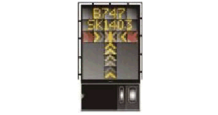
Aircraft type, continuous closing distance, and azimuth guidance, etc., are presented on a single console clearly visible to both the pilot and co-pilot, simultaneously. Figure A shows the Aircraft Display console, mounted on the terminal in front of the aircraft stand.
The system is operated only in the automatic mode. If the system fails, the aircraft must then be marshalled into the stand manually.
Pilot must stop the aircraft immediately if he or she sees that:
The docking system is not activated.
A wrong aircraft type is displayed.
The word STOP is displayed.
A wrong type of aircraft indicates ‘ID FAIL’ is displayed.
13.2.1.3 Docking Procedure
During the docking process, pilot shall confirm that the correct aircraft is displayed on the LED Display Console and proceed slowly forward to parking position.
The following Display Guide shows the azimuth guidance bars at the lower centre of VDGS LED Display Console and interprets the guidance as shown.
Caution: Always steer and follow to the GREEN AZIMUTH CENTRE BAR.
| Aircraft left of centre line, steer towards GREEN | Aircraft on centre line | Aircraft right of centre line, steer towards GREEN |
|---|---|---|
 |  |  |
The figure below shows the azimuth guidance status on the LED Display Console indicating the aircraft azimuth position when an aircraft approaching to parking position.
 | Green light bar illuminates, the aircraft is on centre line. Keep straight ahead. |
 | If red light bar appears on the left side of the green light bar, the aircraft is off centre line to left. It should be moved rightwards. |
 | If red light bar appears on the right side of the green light bar, the aircraft is off centre line to right. It should be moved leftwards. |
The pilot display of the Advanced Visual Docking Guidance System (A-VDGS) is shown below:
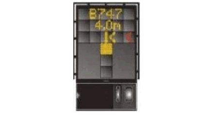
PARKING SEQUENCE:
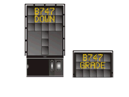
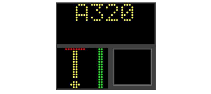 | In this picture the aircraft is at a distance greater than Note that the digital close-in distance is not displayed when the aircraft is greater than 30 m away from the stop position. An Airbus A320 aircraft is expected. |
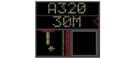 | In this picture the aircraft is at exactly 30 m from Starting at 30 m, the digital close-in distance (second line of display) is displayed, in 1 m decrements. |
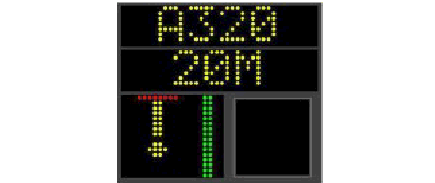 | The aircraft is at 20 m from the stop position and has returned to the centre line. Note: the position of progress meter. The arrow will advance one position every 2.5 m. |
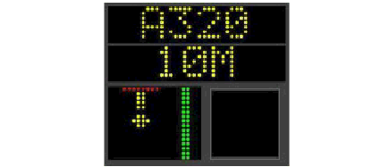 | In this picture the aircraft is at 10 m and is on |
 | The aircraft is now at 3.2 m from the stop position and is on the centre line. Note that at below 5 m, the close-in distance is displayed in 0.2 m decrements. |
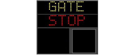
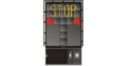
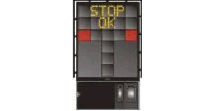
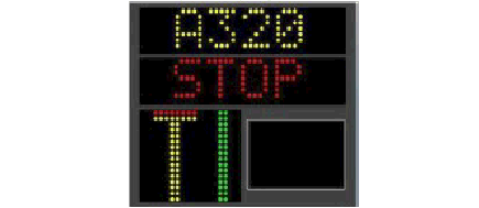 | Finally the aircraft is perfectly parked at the stop position, and perfectly centred. The word “STOP” is displayed in red. Note also the merging of the arrow and the stop line |
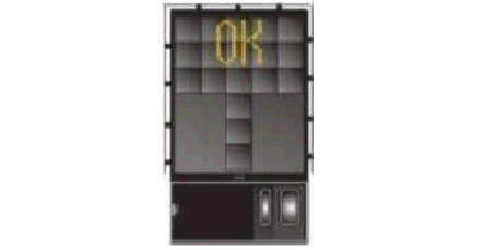
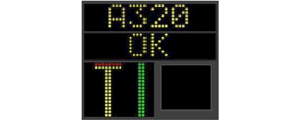 | The word “OK” is displayed in yellow. Docking is successful. |
SLOW:
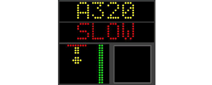 | During the docking process, the pilot must taxi into the aircraft stand at minimum speed. If the system detects that the aircraft is moving too quickly, exceeding the preset speed limit for accurate detection, it will display "SLOW". Once the aircraft's speed is reduced to the acceptable range, the "SLOW" message will be switched back to the numerical close-in distance. |
ID FAIL:
  | For this aircraft type ID verification features, the incoming aircraft must be identified and verified at least 12 m before the stop position or otherwise, the system will display “ID FAIL” alternating ID/FAIL on the first row of the display.
|
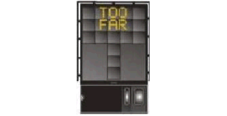
TOO FAR:
 | If the aircraft overshoots the preset range (more than The second row of the docking screen will indicate “STOP”.
|
ERROR STOP:
 | The system will display "ERROR" on the first row of the display as indicated if the system detects any hardware error that might affect the normal docking process. The second row of the display will indicate “STOP”. |
GATE BLOCKED:
  | If an object is found blocking the view from the VDGS to the planned stop position for the aircraft, the docking procedure will be halted with "GATE BLOCK" message. The second row of the display will indicate "STOP". |
EMERGENCY STOP:
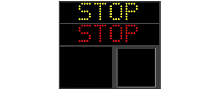 | The first and second row of the display will show “STOP”. |
The VDGS System has built in error detection program to inform the aircraft pilot of impending dangers during the docking procedure.
Warning: If the pilot is unsure of the information, being shown on the VDGS display unit, he must immediately stop the aircraft and obtain further information for clearance.
Warning: The pilot shall not enter the stand area unless the docking system first is showing the vertical running arrows. The pilot must not proceed beyond the bridge unless these arrows have been superseded by the closing rate bar.
Warning: The pilot shall not enter the stand area unless the aircraft type displayed is equal to the approaching aircraft. The correctness of other information, such as “Door 2” shall also be checked.
13.2.2.4 Docking Procedure
START-OF-DOCKING:
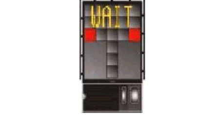 | Pressing one of the aircraft type buttons on the Operator Panel starts the system. When the button has been pressed, "WAIT" will be displayed. |
CAPTURE:
 | The floating arrows indicate that the system is activated and in capture mode, searching for an approaching aircraft. |
TRACKING:
 | When the laser has caught the aircraft, the floating arrowsare replaced by the yellow centre line indicator. |
CLOSING RATE:
 | Display of digital countdown will start when the aircraft is20 m from stop position. This information is shown insteadof the flight number. |
ALIGNED TO CENTRE:
 | The aircraft is 8 m from the stop position. The absence of direction arrow indicates an aircraft on the centre line. |
SLOW DOWN:
 | If the aircraft is approaching faster than the accepted speed, the system will show "SLOW DOWN" alternating SLOW/DOWN as a warning to the pilot. |
AZIMUTH GUIDANCE:
 | The yellow arrow indicates an aircraft to the right ofthe centre line, and the red flashing arrow indicatesthe direction to turn. The aircraft is 4 m from the stop position in this example. |
STOP POSITION REACHED:
 | When the correct stop position is reached, the displaywill show STOP and red lights will be lit. |
DOCKING COMPLETED:
 | When the aircraft has parked, "OK" will be displayed. |
OVERSHOOT:
 | If the aircraft has overshot the stop position more than |
STOP SHORT:
 | If the aircraft is found standing still but has not reached Also the red lights are lit. |
BAD WEATHER CONDITION:
 | During heavy fog or rain, the visibility for the dockingsystem can be reduced. When the system is activated and in capture mode, and a downgrade condition is detected, the pilot display will start flashing the aircraft type, show a " DOWN GRADE " alternating DOWN/GRADE and replace the rolling arrows with a blank lead-in display. The blank lead-in display will be replaced with the normallead-in bar, once Safedock has been able to acquire a lockonto the aircraft. The DOWN GRADE messageand the flashing aircraft type will remain in the displaythroughout the docking procedure. The pilot must immediately stop the aircraft and follow manual guidance (aircraft marshalling). |
AIRCRAFT VERIFICATION FAILURE:
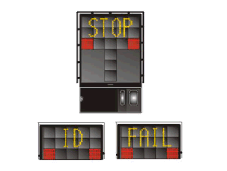 | During entry into the stand, the aircraft geometry is beingchecked. If, for any reason, aircraft verification is not made12 m before the stop position, a second verification check will be conducted. If this check fails, "STOP" and "ID FAIL" will be displayed. The text will be alternating on the upper two rows of the display. The pilot must immediately stop the aircraft and follow manual guidance (aircraft marshalling). |
GATE BLOCKED:
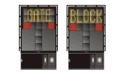 | If an object is found blocking the view from the VDGS to the planned stop position for the aircraft, the dockingprocedure will be halted with "GATE BLOCK" alternating GATE/BLOCK. The pilot must immediately stop the aircraft and follow manual guidance (aircraft marshalling). |
VIEW BLOCKED:
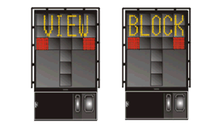 | If the view towards the approaching aircraft is hindered for instance by dirt on the window, the VDGS will display "VIEW BLOCK" alternating VIEW/BLOCK to reporta view block condition. The pilot must immediately stop the aircraft and follow manual guidance (aircraft marshalling). |
SBU-STOP:
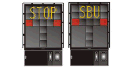 | Any unrecoverable error during the docking procedurewill generate an SBU (safety backup) condition.The display will show red stop bar and the text "STOP SBU" alternating STOP/SBU. The pilot must immediately stop the aircraft and follow manual guidance (aircraft marshalling). |
EMERGENCY STOP:
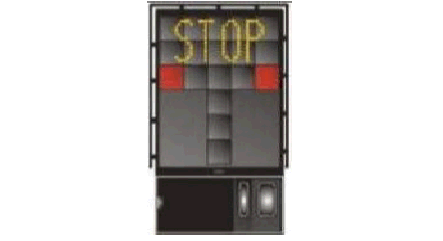 | When the Emergency Stop button is pressed, "STOP" is displayed with red squares. |
CHOCK ON:
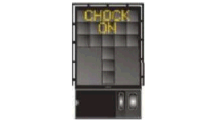 | "CHOCK ON" will be displayed, when the ground staff has completed chocking the wheel of the aircraft and pressed the Chocks On button on the Operator Panel. |
ERROR:
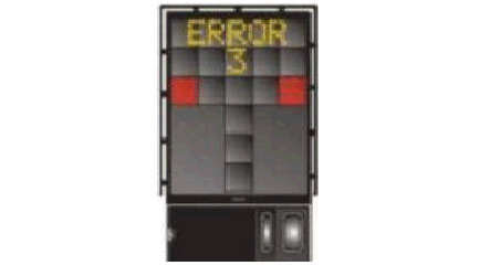 | If a system error occurs, the message "ERROR" is displayed with a code. The code is used for maintenancepurposes and explained elsewhere. |
SYSTEM BREAKDOWN:
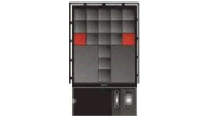 | In case of a severe system failure, the display will go black except for a red stop indicator. A manual guidance (aircraft marshalling) must be used for docking guidance. |
POWER FAILURE:
 | In case of a power failure, the display will be completelyblack. A manual guidance (aircraft marshalling) must be used for docking guidance. |
The display unit provides textual and numerical information, including the continuous real-time azimuth guidance based on the Moiré technique, along with the progress bar and numerical close-in distance to the parking position based on the LADAR (Laser Detection and Ranging) sensor with extending up to 200 m operational range, however, it may be affected by weather conditions.
The sub-display (co-pilot azimuth guidance) is solely intended for use by the co-pilot.
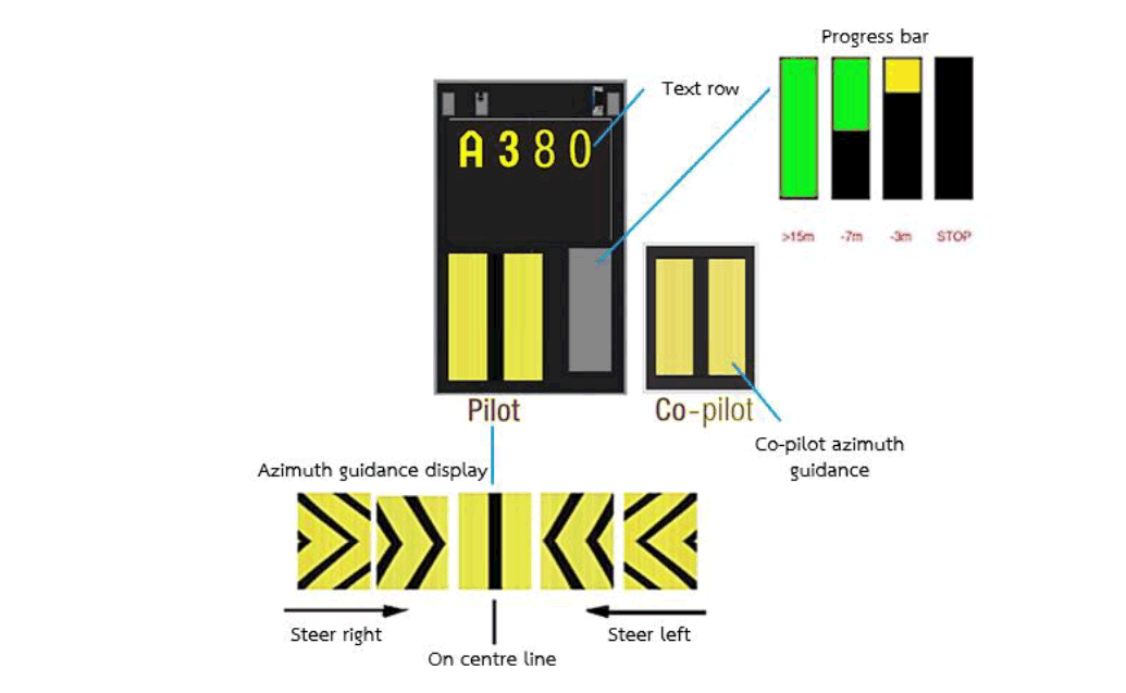
When approaching the centre line, the pilot adjusts the steering in accordance with the direction indicated by the arrow pattern on the azimuth guidance display. When the arrow aligns into a straight line, it confirms that the aircraft is correctly positioned on the centre line.
Pilot must stop the aircraft immediately if the display shows:
Stop
Wrong aircraft type/series
Azimuth guidance and/or LED display is deactivated
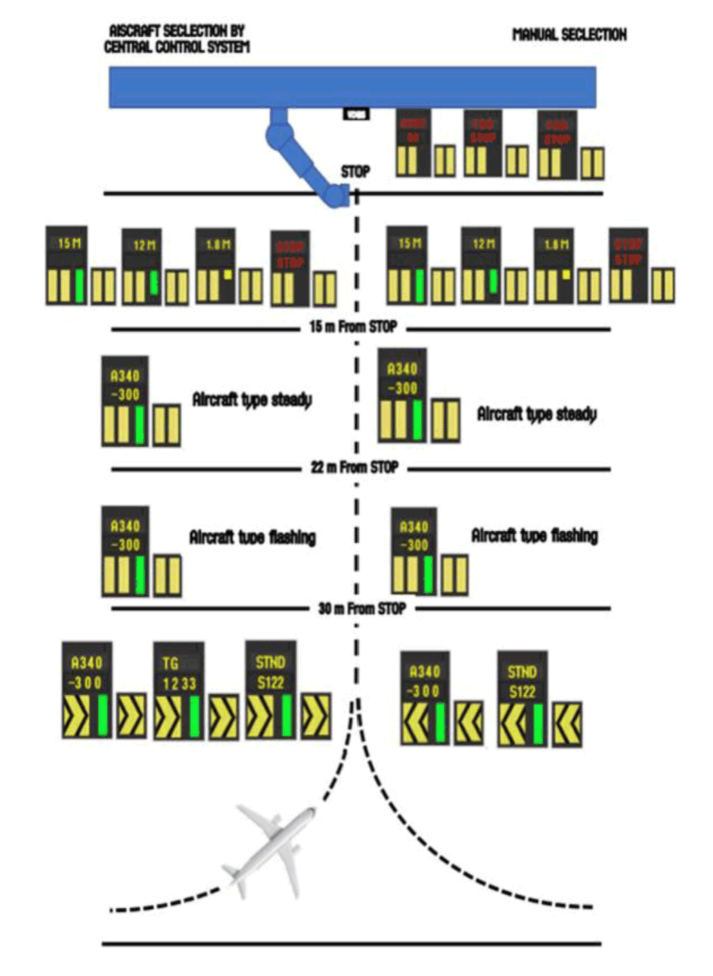
PARKING SEQUENCE:
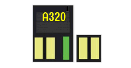 | In this picture the aircraft is at a distance greater than |
 | In this picture the aircraft is at exactly 15 m from the stop position and is on the centre line. |
 | In this picture the aircraft is at 10 m and is on the centre line. |
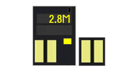 | The aircraft is now at 2.8 m from the stop position and is on the centre line. |
 | Finally, the aircraft is perfectly parked at the stop position, and perfectly centred. |
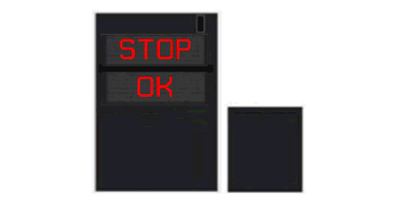 | When docking is successful. |
SLOW DOWN:
 | During the docking process, the pilot must taxi into the aircraft stand at the minimum speed. If the system detects that the aircraft is moving too quickly, exceeding the preset speed limit for accurate detection, it will display "SLOW" on the first line and "DOWN" on the second line. |
AIRCRAFT VERIFICATION FAIL:
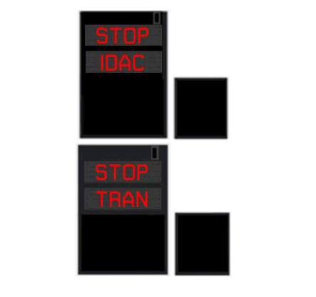 | For this aircraft verification features, the incoming aircraft must be identified and verified at least 12 m before the stop position or otherwise, the system will display "STOP IDAC" or "STOP TRAN". |
TOO FAR:
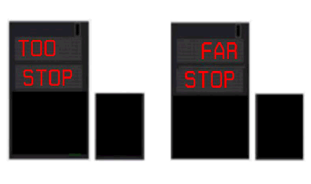 | If the aircraft overshoots the preset range (more than 1 m, or 0.5 m for Airbus A380), the system will display "TOO" and "FAR" alternately on the first row of the display. |
EMERGENCY STOP:
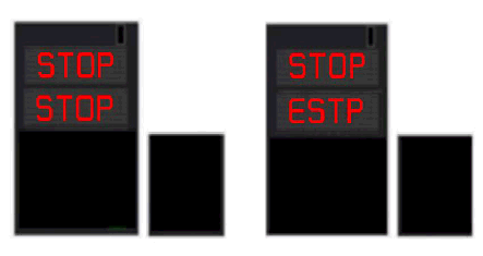 | When the emergency stop button is activated, the system will display "STOP" on the first row and display "STOP" and "ESTP" alternately on the second row until the button is released. |
BRIDGE IN STOP:
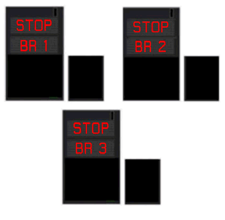 | If the bridge is not in a safe position, the system will display "STOP" on the first row and display "BR1" or "BR2" or "BR3" on the second row. |
OBSTACLE STOP:
 | If an object is found blocking the view from the VDGS to the planned stop position for the aircraft, the system will display "STOP" on the first row and display "OBST" on the second row. |
ERROR CODE:
 | If there is any fault or error, it will stop the docking, and the system will display "STOP" on the first row and display the corresponding error code on the second row. |
Passenger loading bridges will be activated in the range as follows:
between 0.01 - 1.50 m are normally serviceable.
between 1.51 - 2.00 m, passenger loading bridge (PLB) called "L1" is only serviceable, if the PLB called "L2" is required, the aircraft shall push back to correct stop-position.
the distance over 2.00 m, passenger loading bridges are unserviceable, if required the aircraft shall pushed back to correct stop-position.
Any overshoot distance is made by A380, push back to correct stop position is needed when passenger loading bridges are required.
Remark: The identification of passenger loading bridge (L1 or L2) is followed by aircraft door positions.
Emergency stop buttons are available at both of contact gates and remote parking stand. When unsafe situation is considered, the emergency stop button shall be pressed by bridge driver, marshaller or the ground engineer of the airline or handling agent.
Emergency stop buttons are installed in the locations as follows:
At the control panel in the bridge cab
At the bridge rotunda
At the stand identification posts
14. AIRPORT COLLABORATIVE DECISION MAKING (A-CDM)
This section details the key operational aspects of the Airport Collaborative Decision Making (A-CDM) process at Suvarnabhumi Airport, focusing on Target Off-Block Time (TOBT), Target Start-Up Approval Time (TSAT), and start-up and pushback procedures.
It defines the roles and responsibilities necessary to ensure efficient and coordinated pre-departure operations, helping to minimize delays and optimize airport efficiency.
The chart below describes the simple overview of the Pre-Departure process at Suvarnabhumi International Airport from the time that airlines input the TOBT to the time that aircraft is airborne. It includes the responsibilities and procedures in brief, as described below.
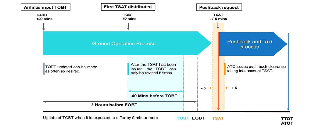
The TOBT is the essential contribution of airlines to the A-CDM process which establishes the Pre-Departure Sequence taking into account operators preferences and operational constraints. Airlines or person responsible for the TOBT are required to access and manually input the TOBT into the A-CDM Portal in order that the start-up approval time (TSAT) can be expected.
Aircraft operator (AO) is responsible for the input of and adherence to the TOBT. However, AO may prefer to delegate this function to ground handler (GH). It is the responsibility of the AO/GH to communicate and ensure that the pilot of a flight has the correct TOBT and TSAT prior to requesting ATC clearance.
AO need to ensure that a timely, accurate and stable TOBT is provided. If it becomes obvious that the TOBT cannot be respected,
it shall be updated by the person responsible for the TOBT as early as possible.
The following has to be taken into account for the input and/or revision of the TOBT:
The initial TOBT can be entered up to 120 minutes (2 hours) before the Estimated Off-Block Time (EOBT).
TOBT entries cannot be set to a time earlier than the current time.
TOBT updates can be made as frequently as necessary until the TSAT is issued (40 minutes before TOBT).
After the TSAT is issued, the TOBT can be revised up to 5 times to maintain operational stability.
Any new TOBT must differ by at least 5 minutes (+/ - 5 minutes) from the last entered TOBT to ensure a consistent
Pre-Departure Sequence.
Flights with CTOT will usually take priority when calculating TSATs in order to minimize potential CTOT delay.
Only users authorized to input or revise TOBT can delete a TOBT.
If the TOBT is deleted, the TSAT will be automatically deleted.
The TOBT must be deleted in the following situations:
When the TOBT cannot be estimated, such as due to technical problems with the aircraft., or
When the permitted number of TOBT inputs (5 times) after the generation of the TSAT has been exceeded.
If a new TOBT is available, the process shall continue, and the responsible person must input the new TOBT.
The TOBT is reported or updated by the following ways:
A-CDM Portal Web Based Application (https://acdm.airportthai.co.th/)
A-CDM Portal Mobile Application
The TSAT is calculated based on the following key parameters:
Target Off-Block Time (TOBT)
Calculated Take-Off Time (CTOT)
Operation Capacity
Variable Taxi Time (VTT)
Parking Stand
Departure Runway
The TSAT is displayed and distributed 40 minutes prior to the TOBT.
After TSAT has been distributed, the TOBT can only be revised not more than 5 times to ensure a stable sequence and accurate CTOT allocation.
Any subsequent TOBT revision will trigger a recalculation of the TSAT. An incorrect TOBT can lead to disadvantages in further sequencing and/or CTOT allocation for regulated flights.
The TSAT may be subject to change and can be revised due to air traffic management considerations.
The AO or GH is responsible for updating and ensuring that the pilot has the correct TOBT and TSAT before requesting ATC clearance.
The TSAT will be issued to airlines or person responsible for TOBT via:
A-CDM Portal Web Based Application (https://acdm.airportthai.co.th/)
SMS via digital trunked radio system
A-CDM Portal Mobile Application
Start-up and push back approval are issued taking into account the TOBT and TSAT. The sequence of the start-up and push back request is no longer a factor. The following rules apply:
To ensure the pilot receives accurate TOBT and TSAT before requesting start -up and pushback clearance, the AO or GH shall communicate and confirm the times with the pilot in advance.
Pilots shall ensure that the aircraft is ready for pushback at the TOBT
After obtaining ATC clearance, the pilot shall monitor the designated Ground Control frequency according to the aircraft parking stand.
If there is any change to the TSAT, Ground Control will update the pilot as soon as possible.
The pilot shall contact Ground Control for start-up and push back at TSAT +/- 5 minutes (TSAT window). The following scenarios may occur:
Before the TSAT window: The flight will be asked to call again when it is within the TSAT window.
Within the TSAT window: The flight will be planned for the outbound sequence and can expect start-up approval directly or within a few minutes, depending on the actual operational situation.
After the TSAT window: The TSAT for the flight has expired. The flight will be denied start-up approval. The pilot must contact the AO/GH to update the TOBT and then contact ATC again once the TOBT update has resulted in a new TSAT.
Ground Control will issue start-up and push back clearance taking the TSAT into account.
If a flight is unable to pushback due to the aircraft not being ready, the TSAT will be cancelled. The pilot must notify the AO/GH to update the TOBT for a new TSAT.
Note: When a departing aircraft is occupying a gate that has been assigned to an arriving aircraft, the departing aircraft may be instructed by ground control to push back onto the taxiway without engine start-up to allow the arriving aircraft to taxi in. An Expected Taxi Time will be provided accordingly.
VTBS AD 2.21 NOISE ABATEMENT PROCEDURES
1. NOISE ABATEMENT PROCEDURES AT SUVARNABHUMI INTERNATIONAL AIRPORT DETAIL AS FOLLOW:
All departing aircraft are required to apply noise abatement procedure with thrust reduction at 1 500 ft AGL, And acceleration at
3 000 ft AGL.
VTBS AD 2.22 FLIGHT PROCEDURES
1. Provision of ATS Surveillance Services
2. Approach Procedures
3. Standard Instrument Departures/Arrivals (RNAV SIDs/STARs)
| OUTBOUND ROUTES | SIDs NAME | SID VTBS | |||||||||||
|---|---|---|---|---|---|---|---|---|---|---|---|---|---|
| JET | PROPELLER | ||||||||||||
| 20R | 02L | 20L | 02R | 19 | 01 | 20R | 02L | 20L | 02R | 19 | 01 | ||
| A1, Y14 | SELKA | 1E | 1F | 1G | 1H | 1J | 1K | 1P | 1Q | 1R | 1S | 1T | 1U |
| Y16 | LIPLI | 1E | 1F | 1G | 1H | 1J | 1K | 1P | 1Q | 1R | 1S | 1T | 1U |
| G474, L880 | DOSBU | 1E | 1F | 1G | 1H | 1J | 1K | 1P | 1Q | 1R | 1S | 1T | 1U |
| B204, N506, R468 | GOMES | 1E | 1F | 1G | 1H | 1J | 1K | 1P | 1Q | 1R | 1S | 1T | 1U |
| N891 | RYN | 1E | 1F | 1G | 1H | 1J | 1K | 1P | 1Q | 1R | 1S | 1T | 1U |
| R201, M904, Y11 | BUT | 1E | 1F | 1G | 1H | 1J | 1K | 1P | 1Q | 1R | 1S | 1T | 1U |
| M757 | KASNI | 1E | 1F | 1G | 1H | 1J | 1K | 1P | 1Q | 1R | 1S | 1T | 1U |
| A464, M751, W19 | REGOS | 1E | 1F | 1G | 1H | 1J | 1K | 1P | 1Q | 1R | 1S | 1T | 1U |
| G458 | UKERA | 1E | 1F | 1G | 1H | 1J | 1K | ||||||
| HOTEL | 1P | 1Q | 1R | 1S | 1T | 1U | |||||||
| W31 | HHN | 1E | 1F | 1G | 1H | 1J | 1K | ||||||
| HOTEL | 1P | 1Q | 1R | 1S | 1T | 1U | |||||||
| Y8 | VANKO | 1E | 1F | 1G | 1H | 1J | 1K | ||||||
| M502 | BONVO | 1E | 1F | 1G | 1H | 1J | 1K | ||||||
| L301 | PASTO | 1E | 1F | 1G | 1H | 1J | 1K | ||||||
| G463, P646 | TARED | 1E | 1F | 1G | 1H | 1J | 1K | ||||||
| L507 | NUNLI | 1E | 1F | 1G | 1H | 1J | 1K | 1P | 1Q | 1R | 1S | 1T | 1U |
| Y26 | OLVUK | 1E | 1F | 1G | 1H | 1J | 1K | ||||||
| Y27 | UGUVO | 1E | 1F | 1G | 1H | 1J | 1K | ||||||
| A464 | SEMBO | 2E | 2F | 2G | 2H | 2J | 2K | 1P | 1Q | 1R | 1S | 1T | 1U |
| W9 | BLAFF | 1P | 1Q | 1R | 1S | 1T | 1U | ||||||
| B346, W21, W39 | NOBER | 2E | 2F | 2G | 2H | 2J | 2K | 1P | 1Q | 1R | 1S | 1T | 1U |
| R474 | ALBOS | 1E | 1F | 1G | 1H | 1J | 1K | 1P | 1Q | 1R | 1S | 1T | 1U |
Note: Pilots of Non-RNAV equipped aircraft shall inform ATC and request for vectors.
| INBOUND ROUTES | TRANSITION WAYPOINT | STAR VTBS | |
|---|---|---|---|
| 19/20L/20R | 01/02L/02R | ||
| W1, Y1, Y2 | UBLOD | EASTE 1C | EASTE 1D |
| Y13 | RUKSA | ||
| G474, L880 | ANREN | TUMGA 1C | TUMGA 1D |
| M633 | DULEM | ||
| N506, R468 | GOMES | ||
| P629 | NUGPA | ||
| N891 | RYN | ||
| Y12 | ALEMI | ||
| R201 | BUT | ||
| A464, M751, W19 | GUTSO | LEBIM 1C | LEBIM 1D |
| M769, Y98 | SURMA | ||
| G458, W31, Y99 | HOTEL | ||
| M502 | BONVO | WILLA 1C | WILLA 1D |
| L301 | PASTO | ||
| L524 | IBETO | ||
| G463, P646 | TARED | ||
| L507 | IGONI | ||
| A464 | SEMBO | NORTA 1C | NORTA 1D |
| W9, Y7, Y28 | TL | ||
| B346, W21, W39 | NOBER | ||
| R474 | ALBOS | ||
Note: Pilots of Non-RNAV equipped aircraft shall inform ATC and request for vectors.
4. Speed Control and Altitude Restrictions Promulgation in Bangkok TMA
In order to facilitate the air traffic flow procedure of departing and arriving aircraft within Bangkok TMA, speed control procedures and altitude restrictions must be applied to optimize the spacing between aircraft and reduce the overall delay of traffic.
When a departing aircraft on a SID is cleared to climb to a level higher than the initially cleared level or the level(s) specified in the SID, the aircraft shall nevertheless follow the published vertical profile, unless such restrictions are explicitly cancelled by ATC.
5. TCAS RA Warning
Avoidance of unnecessary TCAS RA warning, aircraft shall strictly use rate of climb or rate of descent at 1500 fpm or less within 2000 ft to the assigned altitude or flight level, then use rate of climb or rate of descend at 1000 fpm or less within 1000 ft to the assigned altitude or flight level when flight crew is made aware of another aircraft at or approaching an adjacent altitude or flight level, unless otherwise instructed by ATC.
6. Operational for safety and more effective Air Traffic Management in Bangkok TMA.
Suvarnabhumi Departure shall be established to provide Air Traffic Control Service at Suvarnabhumi International airport, the operational procedures shall be as follows:
7. Reduce communication workload
8. Delay during severe weather
4 minutes or more between successive departures on the same SID or between aircraft intending to fly in the direction where severe weather is reported
4 minutes or more between successive arrivals on the same STAR/at the same IAWP or between aircraft intending to fly in the direction where severe weather is reported
9. VFR Flights at VTBS
A pilot wishing to conduct special VFR flight is to call Bangkok Approach on frequency 125.8 MHz for special VFR clearance.
The VFR entry and exit procedures are designed to enhance the uniformity of light aircraft and helicopter operations under VFR in Bangkok Control Zone.
If the communication could not be done through radio frequencies as specified, or the transponder unable to functional operated. The VFR light aircraft and helicopter may not permit to operate.
VFR entry and exit procedure charts are the recommended flight paths and altitudes for the purpose of air traffic management.
Adherence to charted flight paths and altitudes is not mandatory. ATC may assign flight paths and altitudes other than specified in charts, however, pilot has final authorities to decide whether he or she would comply with it but shall comply with VFR.
There is no substitute for alertness while operating under VFR. Pilots still have full responsibility to see and avoid other traffic and maintain adequate distance from clouds. Separation shall be provided in accordance with VFR in Class C airspace.
Under some circumstances, suggest heading or change of altitude may be provided when requested by a pilot or whenever deemed necessary by ATC in the interest of safety and with pilot acceptance. Pilots should, as early as practicable, advise ATC if VMC conditions cannot be maintained. ATC shall request pilot’s intentions and revise the instruction as requested or, if unable, issue an alternative clearance as soon as possible.
The VFR entry and exit procedures are to be flown only in daylight hours between sunrise to sunset.
The procedures for light aircraft are designed for aircraft with speed less than 130 knots.
For light aircraft with speed of more than 130 knots, ATC may either authorize the aircraft to follow the prescribed VFR entry and exit procedures or assign flight paths and altitudes. However, pilot has final authorities to decide whether he or she would comply with it but shall always comply with VFR and pilots still have full responsibility to see and avoid other traffic as well as maintain adequate distance from clouds. Separation shall be provided in accordance with VFR in Class C airspace.
Table of reporting points for light aircraft
| Reporting Points | Landmark | Radial/DME from BKK VOR | Coordinates | |
|---|---|---|---|---|
| Latitude | Longitude | |||
| AYUTTHAYA | Preedee-Thamrong Bridge Crossing Pasak River | R-359 / 27.5D | 14° 21' 08.00'' N | 100° 34' 53.00'' E |
| BANG LEN | Scan Inter Solar Power Plant, Bang Phasi, Bang len | R-293 / 20.3D | 14° 01' 42.00'' N | 100° 16' 24.00'' E |
| BANG LUK SUA | Pradhana Vanalai Studio | R-070 / 28.3D | 14° 03' 26.00'' N | 101° 03' 05.00'' E |
| BANG NAM PRIAO | Bang Nam Priao Intersection | R-095 / 26.6D | 13° 51' 05.00'' N | 101° 02' 58.00'' E |
| BANGPU | Sukta Bridge | R-170 / 23.1D | 13° 30' 44.00'' N | 100° 39' 44.00'' E |
| BANG SAO THONG | Assumption University Suvarnabhumi Campus, Bang Sao Thong | R-141 / 22.0D | 13° 36' 44.00'' N | 100° 50' 17.00'' E |
| BANG PAKONG | Devahastin Bridge, Bangna-Chonburi Expressway Crossing Bang Pakong River | R-136 / 33.9D | 13° 29' 13.20'' N | 101° 00' 07.80'' E |
| BHUMIBOL BRIDGE | Industrial Ring Rd. Interchange between Bhumibol 1-2 Bridge near Lat Pho Canal | R-194 / 14.0D | 13° 40' 03.00'' N | 100° 32' 09.00'' E |
| DON FAEK | Motorway Bang Yai-Kanchanaburi Bridge Crossing Tha Chin River 4 | R-263 / 21.7D | 13° 51' 04.00'' N | 100° 13' 28.00'' E |
| EKACHAI | Ekachai Golf and Country Club | R-223 / 21.7D | 13° 37' 37.00'' N | 100° 20' 38.00'' E |
| HIN KONG | Hin Kong Interchange, Phahonyothin Rd. | R-030 / 35.2D | 14° 24' 30.00'' N | 100° 52' 40.00'' E |
| KOH SICHANG | Koh Sichang | R-165 / 47.4D | 13° 07' 45.00'' N | 100° 48' 40.00'' E |
| LAT BUA LUANG | Singha Beverage Co., Ltd. Ladbualuang | R-312 / 24.5D | 14° 10' 08.00'' N | 100° 16' 48.00'' E |
| PAKNAM | Samuthprakarn Learning Park and Tower | R-179 / 17.6D | 13° 35' 53.82'' N | 100° 35' 56.21'' E |
| SAMUT SAKHON | Thachalom Roundabout | R-222 / 28.4D | 13° 32' 17.00'' N | 100° 16' 20.00'' E |
| SUAN LUANG | Rama 9th Park | R-158 / 11.7D | 13° 41' 19.00'' N | 100° 39' 48.00'' E |
d) VFR ENTRY AND EXIT PROCEDURES FOR LIGHT AIRCRAFT CHART BANGKOK/SUVARNABHUMI INTL (VTBS)
RWY 19/20L/20R 01/02L/02R
I) Departure Procedures
EASTBOUND
BANG SAO THONG [ALT1000] - BANG NAM PRIAO [ALT2500] THEN JOIN VFR ENTRY AND EXIT PROCEDURE FOR LIGHT AIRCRAFT CHART BANGKOK/DON MUEANG INTL (VTBD) RWY 03L/03R 21L/21R
BANG SAO THONG [ALT1000] - BANG PAKONG [ALT2500] THEN JOIN VFR ENTRY AND EXIT PROCEDURE FOR LIGHT AIRCRAFT CHART BANGKOK/DON MUEANG INTL (VTBD) RWY 03L/03R 21L/21R
SOUTHEASTBOUND
SUAN LUANG [ALT1000] - PAK NAM [ALT1000] - BANGPU [ALT1000] - KOH SICHANG [ALT3500] or - BANGPAKONG [ALT2500] - KOH SICHANG [ALT3500]
SUAN LUANG [ALT1000] - PAK NAM [ALT1000] - BANGPU [ALT1000] - BANGPAKONG [ALT2500] - KOH SICHANG [ALT3500]
WESTBOUND
SUAN LUANG [ALT1000] - BHUMIBOL BRIDGE [ALT1500] - EKACHAI [ALT2500] THEN JOIN VFR ENTRY AND EXIT PROCEDURE FOR LIGHT AIRCRAFT CHART BANGKOK/Don Mueang Intl (VTBD) RWY 03L/03R 21L/21R
II) Arrival Procedures
EASTBOUND
BANG NAM PRIAO [ALT2000] - BANG SAO THONG [ALT1000]
BANG PAKONG [ALT2000] - BANG SAO THONG [ALT1000]
SOUTHEASTBOUND
KOH SICHANG [ALT2000] - BANGPU [ALT1000] - PAK NAM [ALT1000] - SUAN LUANG [ALT1000]
KOH SICHANG [ALT2000] - BANGPAKONG [ALT2000] - BANGPU [ALT1000] - PAK NAM [ALT1000] - SUAN LUANG [ALT1000]
WESTBOUND
EKACHAI [ALT2000] - BHUMIBOL BRIDGE [ALT1500] - SUAN LUANG [ALT1000]
The details of VFR ENTRY AND EXIT PROCEDURES FOR LIGHT AIRCRAFT CHART BANGKOK/SUVARNABHUMI INTL (VTBS) RWY 19/20L/20R 01/02L/02R are given in VTBS AD 2.24 CHARTS RELATED TO AN AERODROME
e) VFR OVERFLY PROCEDURES FOR LIGHT AIRCRAFT CHART BANGKOK/SUVARNABHUMI INTL (VTBS)
RWY 19/20L/20R 01/02L/02R
I) Departure Procedures
HIN KONG [ALT3500] - BANG LUK SUA [ALT2500] - BANG NAM PRIAO [ALT2500] - BANG PAKONG [ALT2500] –KOH SICHANG [ALT3500] – SAMUT SAKHON [ALT2500] - DON FAEK [ALT2500] - BANG LEN [ALT2500] - LAT BUA LUANG [ALT2500] - AYUTTHAYA [ALT2500] - HIN KONG [ALT3500]
II) Arrival Procedures
HIN KONG [ALT4500] - BANG LUK SUA [ALT2000] - BANG NAM PRIAO [ALT2000] - BANG PAKONG [ALT2000] –KOH SICHANG [ALT2000] – SAMUT SAKHON [ALT2000] - DON FAEK [ALT2000] - BANG LEN [ALT2000] - LAT BUA LUANG [ALT2000] - AYUTTHAYA [ALT2000] - HIN KONG [ALT4500]
The details of VFR OVERFLY PROCEDURES FOR LIGHT AIRCRAFT CHART BANGKOK/SUVARNABHUMI INTL (VTBS)
RWY 19/20L/20R 01/02L/02R are given in VTBS AD 2.24 CHARTS RELATED TO AN AERODROME
Two-way radio communication shall be established as soon as possible or not later than reaching altitude 500 feet above ground level.
Departing helicopters taking off from Suvarnabhumi international airport or other heliports or helipads within Suvarnabhumi ATZ shall be advised to contact Suvarnabhumi Tower Control on frequency 118.2 MHz or 119.0 MHz for departing instruction. except helicopters operate within area of responsibility of Royal Thai Police Aviation Division (Tarang) contact BAPP (VFR & Helicopter Control: VHC) on frequency 125.8 MHz.
Arriving helicopters intending to land at Suvarnabhumi international airport or other helipads within Suvarnabhumi ATZ shall be advised to contact Suvarnabhumi Tower Control on frequency 118.2 MHz or 119.0 MHz for landing instruction. The completion of landing shall be reported or informed to the appropriate ATS unit as soon as practicable.
Those taking off from heliports or helipads within Bangkok Control Zone outside Don Mueang ATZ and Suvarnabhumi ATZ shall contact BAPP (VHC) on frequency 125.8 MHz.
Adherence to charted flight paths and altitudes is not mandatory. ATC may assign flight paths and altitudes other than specified in charts, however, pilot has final authority to decide whether he or she would comply with it but shall comply with VFR.
Reporting points for helicopter
| Reporting Points | Landmark | Radial/DME from BKK VOR | Coordinates | |
|---|---|---|---|---|
| Latitude | Longitude | |||
| AYUTTHAYA | Preedee-Thamrong Bridge Crossing Pasak River | R-359 / 27.5D | 14° 21' 08.00'' N | 100° 34' 53.00'' E |
| BANG LEN | Scan Inter Solar Power Plant, Bang Phasi, Bang len | R-293 / 20.3D | 14° 01' 42.00'' N | 100° 16' 24.00'' E |
| BANG LUK SUA | Pradhana Vanalai Studio | R-070 / 28.3D | 14° 03' 26.00'' N | 101° 03' 05.00'' E |
| BANG NAM PRIAO | Bang Nam Priao Intersection | R-095 / 26.6D | 13° 51' 05.00'' N | 101° 02' 58.00'' E |
| BANGPU | Sukta Bridge | R-170 / 23.1D | 13° 30' 44.00'' N | 100° 39' 44.00'' E |
| BANG SAO THONG | Assumption University Suvarnabhumi Campus, Bang Sao Thong | R-141 / 22.0D | 13° 36' 44.00'' N | 100° 50' 17.00'' E |
| BANG PAKONG | Devahastin Bridge, Bangna-Chonburi Expressway Crossing Bang Pakong River | R-136 / 33.9D | 13° 29' 13.20'' N | 101° 00' 07.80'' E |
| BHUMIBOL BRIDGE | Industrial Ring Rd. Interchange between Bhumibol 1-2 Bridge near Lat Pho Canal | R-194 / 14.0D | 13° 40' 03.00'' N | 100° 32' 09.00'' E |
| DON FAEK | Motorway Bang Yai-Kanchanaburi Bridge Crossing Tha Chin River 4 | R-263 / 21.7D | 13° 51' 04.00'' N | 100° 13' 28.00'' E |
| EKACHAI | Ekachai Golf and Country Club | R-223 / 21.7D | 13° 37' 37.00'' N | 100° 20' 38.00'' E |
| HIN KONG | Hin Kong Interchange, Phahonyothin Rd. | R-030 / 35.2D | 14° 24' 30.00'' N | 100° 52' 40.00'' E |
| KHLONG CHAN | Rajamangala National Stadium | R-170 / 8.4D | 13° 45' 17.00'' N | 100° 37' 14.00'' E |
| KOH SICHANG | Koh Sichang | R-165 / 47.4D | 13° 07' 45.00'' N | 100° 48' 40.00'' E |
| LAT BUA LUANG | Singha Beverage Co., Ltd. Ladbualuang | R-312 / 24.5D | 14° 10' 08.00'' N | 100° 16' 48.00'' E |
| MINBURI | Bangkok Eastern Outer Ring Rd. Crossing Ram Inthra Rd. | R-133 / 6.4D | 13° 49' 11.00'' N | 100° 40' 35.00'' E |
| PAKNAM | Samuthprakarn Learning Park and Tower | R-179 / 17.6D | 13° 35' 53.82'' N | 100° 35' 56.21'' E |
| SUAN LUANG | Rama 9th Park | R-158 / 11.7D | 13° 41' 19.00'' N | 100° 39' 48.00'' E |
g) VFR ENTRY AND EXIT PROCEDURES FOR HELICOPTER CHART BANGKOK/SUVARNABHUMI INTL (VTBS)
RWY 19/20L/20R 01/02L/02R
I) Departure Procedures
WESTBOUND
SUAN LUANG [ALT1000] - MINBURI [ALT1000] - THEN PROCEED ON VFR ENTRY AND EXIT PROCEDURE FOR HELICOPTER CHART BANGKOK/Don Mueang Intl (VTBD) RWY 21L/21R or RWY 03L/03R
SUAN LUANG [ALT1000] - KLONGCHAN [ALT1500] - THEN PROCEED ON VFR ENTRY AND EXIT PROCEDURE FOR HELICOPTER CHART BANGKOK/Don Mueang Intl (VTBD) RWY 21L/21R or RWY 03L/03R
SUAN LUANG [ALT1000] - BHUMIBOL BRIDGE [ALT1500] - THEN PROCEED ON VFR ENTRY AND EXIT PROCEDURE FOR HELICOPTER CHART BANGKOK/Don Mueang Intl (VTBD) RWY 21L/21R or RWY 03L/03R
SUAN LUANG [ALT1000] - PAKNAM [ALT1000] - EKACHAI [ALT1500] - THEN PROCEED ON VFR ENTRY AND EXIT PROCEDURE FOR HELICOPTER CHART BANGKOK/Don Mueang Intl (VTBD) RWY 21L/21R or RWY 03L/03R
SUAN LUANG [ALT1000] - PAKNAM [ALT1000] - BANGPU [ALT1000] - THEN PROCEED ON VFR ENTRY AND EXIT PROCEDURE FOR HELICOPTER CHART BANGKOK/Don Mueang Intl (VTBD) RWY 21L/21R or RWY 03L/03R
EASTBOUND
BANG SAO THONG [ALT1000] - BANG NAM PRIAO [ALT1500] - THEN PROCEED ON VFR ENTRY AND EXIT PROCEDURE FOR HELICOPTER CHART BANGKOK/Don Mueang Intl (VTBD) RWY 21L/21R or RWY 03L/03R
BANG SAO THONG [ALT1000] - BANG PAKONG [ALT1500] - THEN PROCEED ON VFR ENTRY AND EXIT PROCEDURE FOR HELICOPTER CHART BANGKOK/Don Mueang Intl (VTBD) RWY 21L/21R or RWY 03L/03R
II) Arrival Procedures
WESTBOUND
MINBURI [ALT1000] or KLONGCHAN [ALT1500] or BHUMIBOL BRIDGE [ALT1500] or PAKNAM [ALT1000] - SUAN LUANG [ALT1000]
EASTBOUND
BANG NAM PRIAO [ALT1500] or BANG PAKONG [ALT1500] - BANG SAO THONG [ALT1000]
The details of VFR ENTRY AND EXIT PROCEDURES FOR HELICOPTER CHART BANGKOK/SUVARNABHUMI INTL (VTBS) RWY 19/20L/20R 01/02L/02R are given in VTBS AD 2.24 CHARTS RELATED TO AN AERODROME
h) VFR OVERFLY PROCEDURES FOR HELICOPTER CHART BANGKOK/SUVARNABHUMI INTL (VTBS) RWY 19/20L/20R
01/02L/02R
I) Departure/Arrival Procedures
HIN KONG [ALT1500] - BANG LUK SUA [ALT1500] - BANG NAM PRIAO [ALT1500] - BANG PAKONG [ALT1500] -BANGPU [ALT1000] - PAK NAM [ALT1000] - EKACHAI [ALT1500] - DON FAEK [ALT1500] - BANG LEN [ALT1500] - LAT BUA LUANG [ALT1500] - AYUTTHAYA [ALT1500] - HIN KONG [ALT1500]
Helicopter within Bangkok Control Zone can join all suitable reporting points in VFR ENTRY AND EXIT PROCEDURES FOR HELICOPTER CHART (BANGKOK/DON MUEANG INTL (VTBD) RWY 03L/03R 21L/21R and BANGKOK/SUVARNABHUMI INTL (VTBS) RWY 19/20L/20R 01/02L/02R
The details of VFR ENTRY AND EXIT PROCEDURES FOR HELICOPTER CHART BANGKOK/SUVARNABHUMI INTL (VTBS) RWY 19/20L/20R 01/02L/02R are given in VTBS AD 2.24 CHARTS RELATED TO AN AERODROME
Aircraft will not be permitted to take off unless two-way radio communications can be maintained with the control tower.
Report their position, distance, heading and altitude as well as departure point when approaching 50 NM from BKK VOR by blind transmission.
Observe the direction of traffic in pattern and enter downwind with the flow of traffic.
Conform to the altitude for the type of aircraft as listed in Note below.
Make a low approach along the runways at an altitude of 500 ft, and rock the wings of the aircraft.
Re-enter downwind leg and observe light signals.
Note:
Jet aircraft 1500 ft
Light aircraft 1000 ft
Helicopter 500 ft
10. Departure Clearance Procedures
| Frequency | Outbound routes |
|---|---|
| 128.7 MHz | A464 (Northbound), A464 (Southbound), B346, G458, G463, L301, L507, M502, M751, M757, P646, R474, W9, W19, W21, W31, W39, Y8, Y26, Y27 |
| 133.8 MHz | A1, B204, G474, L880, M904, N506, N891, R201, R468, Y11, Y14, Y16 |
Remark: IFR aircraft departing to VTBD, VTBU, VTBK, VTBL, VTPI and VTPH at or below FL160 are to call Bangkok Approach on 125.8 MHz
Call sign
Type of aircraft
Destination
Route
Proposed flight level, if different from the filed flight plan and,
When applicable, special requirements (e.g. inability to comply with SID climb profile).
Under normal circumstances, altitude 6000 ft shall be initially assigned.
First airborne first flight level selection principle.
No on-ground flight level negotiation and reservations.
Cruising level shall be assigned by Bangkok Control after airborne.
Keep listening watch on relevant Suvarnabhumi Ground Control frequency at all times for additional or revised Departure clearance and in readiness for push back; and
Call Ground Control in the appropriate time with the departure time restriction.
11. Departure Clearance (DCL) via Data Link
a) Southbound: A464, M751, M757, R201, M904, W19, W31, G458, Y8, Y11b) North-Eastbound: A1, Y16, Y14c) Eastbound: G474, R468, N891, B204, N506, L880d) Northbound: A464, R474, W9, W21, W39, B346, Y26, Y27e) Westbound: G463, L301, L507, M502, P646
a) Under normal circumstances, 6 000 ft shall be initially assigned. b) First airborne, first flight level selection principle. c) No on-ground flight level negotiation and reservations. d) Cruising level shall be assigned by Bangkok Control after airborne.
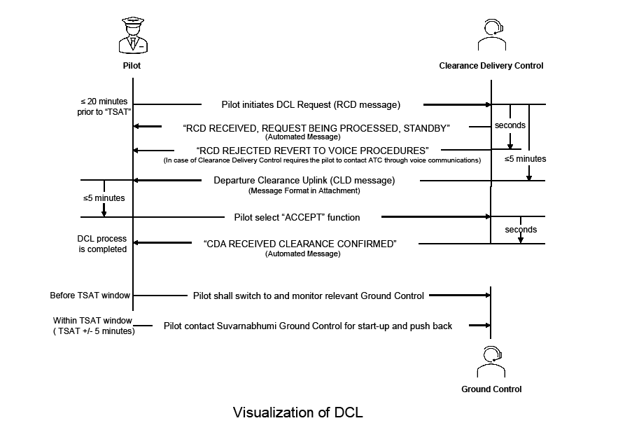
1) Departure Clearance Request (RCD):
DCL Request Message from the aircraft for the initiation of departure clearance process.
RCD 000THA475-VTBS-GATE C3-YSSYATIS C-TYP/A359 |
- Flight System Message (FSM): An automated message from the system.
FSM 0306 240724 VTBS THA475 RCD RECEIVED REQUEST BEING PROCESSED STANDBY |
- Flight System Message (FSM): In case of Clearance Delivery Control requires the pilot to contact ATC through voice communications.
FSM 0306 240724 VTBS THA475 RCD REJECTED REVERT TO VOICE PROCEDURES |
2) Departure Clearance Uplink (CLD):
Departure Clearance Uplink Message from ground system (by Clearance Delivery Control) containing departure clearance.
CLD 0152 240705 VTBS PDC 918 THA475 CLRD TO YSSY OFF 20L VIA BUT1G M904 ALT060 SQUAWK 0734 |
or
CLD 0152 240705 VTBS PDC 918 THA475 CLRD TO YSSY OFF 20L VIA BUT1G M904 ALT060 SQUAWK 0734 CTOT 0210 |
3) Departure Clearance Readback Downlink (CDA):
DCL Readback Message from aircraft.
CDA 0152 240705 VTBS PDC 918 THA475 CLRD TO YSSY OFF 20L VIA BUT1G M904 ALT060 SQUAWK 0734 |
Flight System Message (FSM): An automated message from the system indicating the DCL process is completed.
FSM 0732 240724 VTBS THA475 CDA RECEIVED CLEARANCE CONFIRMED |
If there is any problem with the data link exchanges, pilot shall request the Departure Clearance via voice RTF using the frequencies specified in Section 10.2.1 and inform ATC of the technical difficulty.
12. Fuel Dumping Procedure and In-flight Management Procedures
An aircraft in emergency or other urgent situations may need to dump fuel so as to reduce to maximum landing mass in order to affect a safe landing.
Illustration of Fuel dumping areas
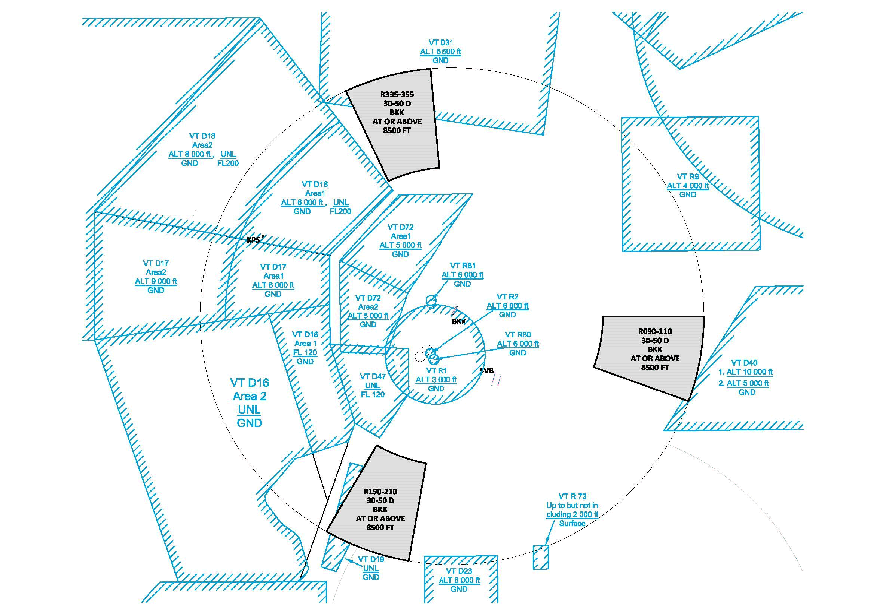
Minimum fuel: The term used to describe a situation in which an aircraft’s fuel supply has reached a state where the flight is committed to land at a specific aerodrome and no additional delay can be accepted.
Mayday fuel: Describes the nature of the distress conditions when the calculated usable fuel predicted to be available upon landing at the nearest aerodrome where a safe landing can be made is less than the planned final reserve fuel
Note 1: The declaration of “MINIMUM FUEL” informs ATC that all planned aerodrome options have been reduced to a specific aerodrome of intended landing and any changes to the existing clearance may result in landing with less than planned final reserve fuel. This is not an emergency situation but an indication that an emergency situation is possible should any additional delays occur.
Note 2: It should be noted that Pilots should not expect any form of priority handling as a result of a “MINIMUM FUEL” declaration. ATC will, however, advise the flight crew of any additional expected delays as well as coordinate when transferring control of the aircraft to ensure that other ATC units are aware of the flight’s fuel state.
Note 1: The planned final reserve fuel refers to the value calculated in Annex 6 - Operation of Aircraft, Chapter4, item 4.3.6.3 e) 1) or 2) and is the minimum amount of fuel required upon landing at any aerodrome.
Note 2: The words “MAYDAY FUEL” describe the nature of the distress conditions as required in Annex 10, Volume II, Chapter 5, Item 5.3.2.1, b) 3).
Note 3: Guidance on procedures for in-flight fuel management is contained in the Fuel Planning Manual (Doc 9976).
The estimated delay, if pilots are en-route to, joining or are established in holding point such as IAWPs; or
The estimated track mileage, if pilots are being vectored to an instrument approach; or
Pilot transmission: (C/S), MINIMUM FUEL
Controller transmission: (C/S), ROGER [NO DELAY EXPECTED or EXPECT (delay information)]
Pilot Transmission: (C/S) MAYDAY, MAYDAY, MAYDAY FUEL
Controller transmission: (C/S) ROGER MAYDAY
13. Aircraft Transponder Failure Procedures
Phraseologies
“C/S, CONFIRM TRANSPONDER ON”, or
“C/S, CHECK YOUR TRANSPONDER OPERATED NORMALLY”, or
“C/S, TRANSPONDER NOT RECEIVED, CHECK FUNCTIONALITY”
When it has been confirmed that aircraft transponder fails, ATC shall advice the pilot to repair it before departure. However, the surface surveillance blind spot, where the transponder might not be easily detected, should be taken into consideration.
Phraseologies
“C/S, ADVISE TRANSPONDER REPAIRED BEFORE DEPARTURE”, or
“C/S, ADVISE RETURN TO BAY FOR TRANSPONDER REPAIRING”
Phraseologies
“C/S, CONFIRM TRANSPONDER ON”, or
“C/S, CHECK YOUR TRANSPONDER OPERATED NORMALLY”, or
“C/S, TRANSPONDER NOT RECEIVED, CHECK FUNCTIONALITY”
When it has been confirmed that the aircraft transponder fails, ATC shall advice the pilot to return to his departure airport as well as relay all necessary information to Aerodrome Control Tower and all concerned units.
Phraseologies
“C/S, ADVISE RETURN TO LAND AT (DEPARTURE AERODROME) FOR TRANSPONDER REPAIRING, REQUEST YOUR INTENTION”,
“C/S, ADVISE RETURN TO BAY FOR TRANSPONDER REPAIRING”
In case pilot decide to proceed to first intended landing or nearest suitable aerodrome, primary radar separation shall be provided. However, the pilot shall be reminded that delays can be expected and some requests might not be granted e.g. route to be flown, cruising altitude/level.
13.2.1 ATC must immediately inform the pilot of his transponder failure so that he could check its operations and repair it.
14. Radio communication failure procedure
Proceed according to the STAR route to the termination point (ATKIN/ESGEN for RWY 19/20L/20R or BOGAS/ENKAA for RWY 01/02L/02R) and descend in accordance with the published all speed and altitude restrictions of the relevant STAR procedure, thence:
For RWY 19/20L/20R:
- After passing ATKIN, the pilot shall fly heading 015 and maintain altitude 6 000 ft for next 10 NM, then turn right and descend to 1 600 ft and carry out the appropriate approach procedure.
- After passing ESGEN, the pilot shall fly heading 015 and maintain altitude 6 000 ft for next 10 NM, then turn left and descend to 1 600 ft and carry out the appropriate approach procedure.
For RWY 01/02L/02R:
- After passing BOGAS, the pilot shall fly heading 195 and maintain altitude 6 000 ft for next 10 NM, then turn left and descend to 1 600 ft and carry out the appropriate approach procedure.
- After passing ENKAA, the pilot shall fly heading 195 and maintain altitude 6 000 ft for next 10 NM, then turn right and descend to 1 600 ft and carry out the appropriate approach procedure.
Pilots may endeavour to communicate with ATC by telephone network.
The telephone numbers are as follows:
Don Mueang Tower Tel: +662 515 3282, +662 515 3288, +6681710 7449
Suvarnabhumi Tower Tel: +662 131 3612, +6681 920 5107
Bangkok Approach Tel: +662 131 3621-2, +6685 150 2288 and +6685 150 3300
15. SIMULTANEOUS PARALLEL RUNWAY OPERATIONS
| ILS z RWY01 | RNP RWY01 |
| - | RNP RWY02L |
| ILS z RWY02R | RNP RWY02R |
| ILS z RWY19 | RNP RWY19 |
| ILS z RWY20L | RNP RWY20L |
| - | RNP RWY20R |
RNP APCH (LNAV) procedures are NOT authorized during simultaneous operations.
The use of Flight Director (FD) or Autopilot (AP) providing RNP track guidance is required during simultaneous operations. FMS functionality to intercept the runway centerline after radar vectoring is also required.
Radar vector to intercept and follow the ILS localizer course or RNP final approach course:
“TURN LEFT (RIGHT) HEADING (three digits), DESCEND AND MAINTAIN (altitude), REPORT ESTABLISHED ON THE LOCALIZER (or FINAL APPROACH COURSE) RUNWAY (number)”Radar vector to intercept and clear for the ILS approach or RNP approach:
“TURN LEFT (RIGHT) HEADING (three digits), DESCEND AND MAINTAIN (altitude), CLEARED FOR ILS z APPROACH (or RNP APPROACH) RUNWAY (number)”
“OBSERVING YOU ARE LEFT (or RIGHT) OF THE LOCALIZER (or FINAL APPROACH COURSE), TURN RIGHT (or LEFT) IMMEDIATELY AND REJOIN THE LOCALIZER (or FINAL APPROACH COURSE)”
Firstly, ATCO will instruct the aircraft on the adjacent ILS localizer course or RNP final approach course to alter its course to avoid the deviating aircraft with the following phraseology:
“TRAFFIC ALERT, TURN RIGHT (or LEFT) IMMEDIATELY HEADING (degrees), CLIMB AND MAINTAIN (altitude) TO AVOID TRAFFIC”Secondly, ATCO will instruct the deviating aircraft to turn away from NTZ immediately for avoidance action, with the following phraseology:
“YOU HAVE CROSSED THE LOCALIZER (or FINAL APPROACH COURSE), TURN RIGHT (or LEFT) IMMEDIATELY HEADING (three digits), CLIMB AND MAINTAIN (altitude) TO AVOID TRAFFIC”
Or
“TURN RIGHT (or LEFT) IMMEDIATELY HEADING (three digits), CLIMB AND MAINTAIN (altitude) TO AVOID TRAFFIC”
VTBS AD 2.23 ADDITIONAL INFORMATION
1. Pilot Advisory
When landing on Runway 19 with winds from the west, aircraft may be affected by turbulence in the vicinity of the building structures (Ground Run-Up Enclosure: GRE). The geographic coordinates of GRE are as follows: 134216.9N 1004552.0E.
2. Bird concentrations
Wildlife Hazard Control staff contact information as below:
Phone +666 3234 4009, +662 132 6981, +662 132 6982
E-mail: [email protected]
Species which account for high to very high to bird strike risk are as follows:
| Species | Weight (kg) | Period |
|---|---|---|
| Rock Pigeon (Columba livia) | 0.270 - 0.380 | All year |
| Little Cormorant (Phalacrocorax niger) | 0.360 – 0.530 | All year (mostly in January and December) |
| Open-billed Stork (Anastomus oscitans) | 2.300 – 4.400 | All year (mostly in March – December) |
| Black-winged Stilt (Himantopus Himantopus) | 0.250 – 0.300 | All year (mostly in April – September) |
| Red Collared Dove (Streptopelia tranquebarica) | 0.080 – 0.100 | All year (mostly in June – October) |
| Little Egret (Egretta garzetta) | 0.500 – 0.630 | All year (mostly in July – October) |
| Red-wattled Lapwing (Vanellus indicus) | 0.110 – 0.230 | All year (mostly in July – October) |
| Cattle Egret (Bubulcus ibis) | 0.300 – 0.400 | All year (mostly in July – November) |
| Painted Stork (Mycteria leucocephala) | 2.000 – 3.000 | All year (mostly in October) |
| Oriental Pratincole (Glareola maldivarum) | 0.070 – 0.095 | All year (Mostly in March - October) |
Remark: Bird concentrations chart is shown in page AD2-VTBS-9-13
Grass areas outside the boundary of runways strip and the critical area.
Grass areas outside the boundary of taxiways strip. For safety reason, the work will temporary stop when taxiing aircraft approaches.
VTBS AD 2.24 CHARTS RELATED TO AN AERODROME
|
Chart name |
Page |
|---|---|
|
Aerodrome Chart - ICAO | AD 2-VTBS-2-1 |
|
Aircraft Parking/Docking Chart - ICAO | AD 2-VTBS-2-3 |
|
Aircraft Parking/Docking Chart - ICAO (Verso 1) | AD 2-VTBS-2-4 |
|
Aircraft Parking/Docking Chart - ICAO (Verso 2) | AD 2-VTBS-2-5 |
|
Aircraft Parking/Docking Chart - ICAO (Verso 3) | AD 2-VTBS-2-6 |
|
Aerodrome Obstacle Chart - ICAO - Type A - RWY 01/19 | AD 2-VTBS-3-1 |
|
Aerodrome Obstacle Chart - ICAO - Type A - RWY 02R/20L | AD 2-VTBS-3-3 |
|
Aerodrome Obstacle Chart - ICAO - Type A - RWY 02L/20R | AD 2-VTBS-3-5 |
|
Precision Approach Terrain Chart - ICAO - RWY 01/19 | AD 2-VTBS-3-7 |
|
Precision Approach Terrain Chart - ICAO - RWY 02R/20L | AD 2-VTBS-3-9 |
|
Precision Approach Terrain Chart - ICAO - RWY 02L/20R | AD 2-VTBS-3-11 |
|
Standard Departure Chart - Instrument (SID) - ICAO - RNAV RWY 01 - ALBOS1K BONVO1K BUT1K DOSBU1K GOMES1K HHN1K KASNI1K LIPLI1K NOBER2K NUNLI1K OLVUK1K PASTO1K REGOS1K RYN1K SELKA1K SEMBO2K TARED1K UKERA1K UGUVO1K VANKO1K | AD 2-VTBS-6-1 |
|
Standard Departure Chart - Instrument (SID) - ICAO – RNAV RWY 01 - ALBOS1K BONVO1K BUT1K DOSBU1K GOMES1K HHN1K KASNI1K LIPLI1K NOBER2K NUNLI1K OLVUK1K PASTO1K REGOS1K RYN1K SELKA1K SEMBO2K TARED1K UKERA1K UGUVO1K VANKO1K (Verso) | AD 2-VTBS-6-2 |
|
Standard Departure Chart - Instrument (SID) - ICAO - RNAV RWY 01 - ALBOS1K BONVO1K BUT1K DOSBU1K GOMES1K HHN1K KASNI1K LIPLI1K NOBER2K NUNLI1K OLVUK1K PASTO1K REGOS1K RYN1K SELKA1K SEMBO2K TARED1K UKERA1K UGUVO1K VANKO1K (Radio communication failure table) | AD 2-VTBS-6-3 |
|
Standard Departure Chart - Instrument (SID) - ICAO - RNAV RWY 01 - ALBOS1K BONVO1K BUT1K DOSBU1K GOMES1K HHN1K KASNI1K LIPLI1K NOBER2K NUNLI1K OLVUK1K PASTO1K REGOS1K RYN1K SELKA1K SEMBO2K TARED1K UKERA1K UGUVO1K VANKO1K (Tabular description1) | AD 2-VTBS-6-4 |
|
Standard Departure Chart - Instrument (SID) - ICAO - RNAV RWY 01 - ALBOS1K BONVO1K BUT1K DOSBU1K GOMES1K HHN1K KASNI1K LIPLI1K NOBER2K NUNLI1K OLVUK1K PASTO1K REGOS1K RYN1K SELKA1K SEMBO2K TARED1K UKERA1K UGUVO1K VANKO1K (Tabular description2) | AD 2-VTBS-6-5 |
|
Standard Departure Chart - Instrument (SID) - ICAO - RNAV RWY 01 - ALBOS1K BONVO1K BUT1K DOSBU1K GOMES1K HHN1K KASNI1K LIPLI1K NOBER2K NUNLI1K OLVUK1K PASTO1K REGOS1K RYN1K SELKA1K SEMBO2K TARED1K UKERA1K UGUVO1K VANKO1K (Tabular description3) | AD 2-VTBS-6-6 |
|
Standard Departure Chart - Instrument (SID) - ICAO - RNAV RWY 01 - ALBOS1K BONVO1K BUT1K DOSBU1K GOMES1K HHN1K KASNI1K LIPLI1K NOBER2K NUNLI1K OLVUK1K PASTO1K REGOS1K RYN1K SELKA1K SEMBO2K TARED1K UKERA1K UGUVO1K VANKO1K (Tabular description4) | AD 2-VTBS-6-7 |
|
Standard Departure Chart - Instrument (SID) - ICAO - RNAV RWY 01 - ALBOS1K BONVO1K BUT1K DOSBU1K GOMES1K HHN1K KASNI1K LIPLI1K NOBER2K NUNLI1K OLVUK1K PASTO1K REGOS1K RYN1K SELKA1K SEMBO2K TARED1K UKERA1K UGUVO1K VANKO1K (Tabular description5) | AD 2-VTBS-6-8 |
|
Standard Departure Chart - Instrument (SID) - ICAO - RNAV RWY 01 - ALBOS1K BONVO1K BUT1K DOSBU1K GOMES1K HHN1K KASNI1K LIPLI1K NOBER2K NUNLI1K OLVUK1K PASTO1K REGOS1K RYN1K SELKA1K SEMBO2K TARED1K UKERA1K UGUVO1K VANKO1K (Tabular description6) | AD 2-VTBS-6-9 |
|
Standard Departure Chart - Instrument (SID) - ICAO - RNAV RWY 01 - ALBOS1K BONVO1K BUT1K DOSBU1K GOMES1K HHN1K KASNI1K LIPLI1K NOBER2K NUNLI1K OLVUK1K PASTO1K REGOS1K RYN1K SELKA1K SEMBO2K TARED1K UKERA1K UGUVO1K VANKO1K (Tabular description7) | AD 2-VTBS-6-10 |
|
Standard Departure Chart - Instrument (SID) - ICAO - RNAV RWY 01 - ALBOS1K BONVO1K BUT1K DOSBU1K GOMES1K HHN1K KASNI1K LIPLI1K NOBER2K NUNLI1K OLVUK1K PASTO1K REGOS1K RYN1K SELKA1K SEMBO2K TARED1K UKERA1K UGUVO1K VANKO1K (Tabular description8) | AD 2-VTBS-6-11 |
|
Standard Departure Chart - Instrument (SID) - ICAO - RNAV RWY 01 - ALBOS1K BONVO1K BUT1K DOSBU1K GOMES1K HHN1K KASNI1K LIPLI1K NOBER2K NUNLI1K OLVUK1K PASTO1K REGOS1K RYN1K SELKA1K SEMBO2K TARED1K UKERA1K UGUVO1K VANKO1K (Tabular description9) | AD 2-VTBS-6-12 |
|
Standard Departure Chart - Instrument (SID) - ICAO - RNAV RWY 01 - ALBOS1K BONVO1K BUT1K DOSBU1K GOMES1K HHN1K KASNI1K LIPLI1K NOBER2K NUNLI1K OLVUK1K PASTO1K REGOS1K RYN1K SELKA1K SEMBO2K TARED1K UKERA1K UGUVO1K VANKO1K (Waypoint list table) | AD 2-VTBS-6-13 |
|
Standard Departure Chart - Instrument (SID) - ICAO -RNAV RWY 02L - ALBOS1F BONVO1F BUT1F DOSBU1F GOMES1F HHN1F KASNI1F LIPLI1F NOBER2F NUNLI1F OLVUK1F PASTO1F REGOS1F RYN1F SELKA1F SEMBO2F TARED1F UKERA1F UGUVO1F VANKO1F | AD 2-VTBS-6-15 |
|
Standard Departure Chart - Instrument (SID) - ICAO -RNAV RWY 02L - ALBOS1F BONVO1F BUT1F DOSBU1F GOMES1F HHN1F KASNI1F LIPLI1F NOBER2F NUNLI1F OLVUK1F PASTO1F REGOS1F RYN1F SELKA1F SEMBO2F TARED1F UKERA1F UGUVO1F VANKO1F (Verso) | AD 2-VTBS-6-16 |
|
Standard Departure Chart - Instrument (SID) - ICAO -RNAV RWY 02L - ALBOS1F BONVO1F BUT1F DOSBU1F GOMES1F HHN1F KASNI1F LIPLI1F NOBER2F NUNLI1F OLVUK1F PASTO1F REGOS1F RYN1F SELKA1F SEMBO2F TARED1F UKERA1F UGUVO1F VANKO1F (Radio communication failure table) | AD 2-VTBS-6-17 |
|
Standard Departure Chart - Instrument (SID) - ICAO -RNAV RWY 02L - ALBOS1F BONVO1F BUT1F DOSBU1F GOMES1F HHN1F KASNI1F LIPLI1F NOBER2F NUNLI1F OLVUK1F PASTO1F REGOS1F RYN1F SELKA1F SEMBO2F TARED1F UKERA1F UGUVO1F VANKO1F (Tabular description1) | AD 2-VTBS-6-18 |
|
Standard Departure Chart - Instrument (SID) - ICAO -RNAV RWY 02L - ALBOS1F BONVO1F BUT1F DOSBU1F GOMES1F HHN1F KASNI1F LIPLI1F NOBER2F NUNLI1F OLVUK1F PASTO1F REGOS1F RYN1F SELKA1F SEMBO2F TARED1F UKERA1F UGUVO1F VANKO1F (Tabular description2) | AD 2-VTBS-6-19 |
|
Standard Departure Chart - Instrument (SID) - ICAO -RNAV RWY 02L - ALBOS1F BONVO1F BUT1F DOSBU1F GOMES1F HHN1F KASNI1F LIPLI1F NOBER2F NUNLI1F OLVUK1F PASTO1F REGOS1F RYN1F SELKA1F SEMBO2F TARED1F UKERA1F UGUVO1F VANKO1F (Tabular description3) | AD 2-VTBS-6-20 |
|
Standard Departure Chart - Instrument (SID) - ICAO -RNAV RWY 02L - ALBOS1F BONVO1F BUT1F DOSBU1F GOMES1F HHN1F KASNI1F LIPLI1F NOBER2F NUNLI1F OLVUK1F PASTO1F REGOS1F RYN1F SELKA1F SEMBO2F TARED1F UKERA1F UGUVO1F VANKO1F (Tabular description4) | AD 2-VTBS-6-21 |
|
Standard Departure Chart - Instrument (SID) - ICAO -RNAV RWY 02L - ALBOS1F BONVO1F BUT1F DOSBU1F GOMES1F HHN1F KASNI1F LIPLI1F NOBER2F NUNLI1F OLVUK1F PASTO1F REGOS1F RYN1F SELKA1F SEMBO2F TARED1F UKERA1F UGUVO1F VANKO1F (Tabular description5) | AD 2-VTBS-6-22 |
|
Standard Departure Chart - Instrument (SID) - ICAO -RNAV RWY 02L - ALBOS1F BONVO1F BUT1F DOSBU1F GOMES1F HHN1F KASNI1F LIPLI1F NOBER2F NUNLI1F OLVUK1F PASTO1F REGOS1F RYN1F SELKA1F SEMBO2F TARED1F UKERA1F UGUVO1F VANKO1F (Tabular description6) | AD 2-VTBS-6-23 |
|
Standard Departure Chart - Instrument (SID) - ICAO - RNAV RWY 02L - ALBOS1F BONVO1F BUT1F DOSBU1F GOMES1F HHN1F KASNI1F LIPLI1F NOBER2F NUNLI1F OLVUK1F PASTO1F REGOS1F RYN1F SELKA1F SEMBO2F TARED1F UKERA1F UGUVO1F VANKO1F (Tabular description7) | AD 2-VTBS-6-24 |
|
Standard Departure Chart - Instrument (SID) - ICAO - RNAV RWY 02L - ALBOS1F BONVO1F BUT1F DOSBU1F GOMES1F HHN1F KASNI1F LIPLI1F NOBER2F NUNLI1F OLVUK1F PASTO1F REGOS1F RYN1F SELKA1F SEMBO2F TARED1F UKERA1F UGUVO1F VANKO1F (Tabular description8) | AD 2-VTBS-6-25 |
|
Standard Departure Chart - Instrument (SID) - ICAO - RNAV RWY 02L - ALBOS1F BONVO1F BUT1F DOSBU1F GOMES1F HHN1F KASNI1F LIPLI1F NOBER2F NUNLI1F OLVUK1F PASTO1F REGOS1F RYN1F SELKA1F SEMBO2F TARED1F UKERA1F UGUVO1F VANKO1F (Tabular description9) | AD 2-VTBS-6-26 |
|
Standard Departure Chart - Instrument (SID) - ICAO - RNAV RWY 02L - ALBOS1F BONVO1F BUT1F DOSBU1F GOMES1F HHN1F KASNI1F LIPLI1F NOBER2F NUNLI1F OLVUK1F PASTO1F REGOS1F RYN1F SELKA1F SEMBO2F TARED1F UKERA1F UGUVO1F VANKO1F (Waypoint list table) | AD 2-VTBS-6-27 |
|
Standard Departure Chart - Instrument (SID) - ICAO - RNAV RWY 02R - ALBOS1H BONVO1H BUT1H DOSBU1H GOMES1H HHN1H KASNI1H LIPLI1H NOBER2H NUNLI1H OLVUK1H PASTO1H REGOS1H RYN1H SELKA1H SEMBO2H TARED1H UKERA1H UGUVO1H VANKO1H | AD 2-VTBS-6-29 |
|
Standard Departure Chart - Instrument (SID) - ICAO - RNAV RWY 02R - ALBOS1H BONVO1H BUT1H DOSBU1H GOMES1H HHN1H KASNI1H LIPLI1H NOBER2H NUNLI1H OLVUK1H PASTO1H REGOS1H RYN1H SELKA1H SEMBO2H TARED1H UKERA1H UGUVO1H VANKO1H (Verso) | AD 2-VTBS-6-30 |
|
Standard Departure Chart - Instrument (SID) - ICAO - RNAV RWY 02R - ALBOS1H BONVO1H BUT1H DOSBU1H GOMES1H HHN1H KASNI1H LIPLI1H NOBER2H NUNLI1H OLVUK1H PASTO1H REGOS1H RYN1H SELKA1H SEMBO2H TARED1H UKERA1H UGUVO1H VANKO1H (Radio communication failure table) | AD 2-VTBS-6-31 |
|
Standard Departure Chart - Instrument (SID) - ICAO - RNAV RWY 02R - ALBOS1H BONVO1H BUT1H DOSBU1H GOMES1H HHN1H KASNI1H LIPLI1H NOBER2H NUNLI1H OLVUK1H PASTO1H REGOS1H RYN1H SELKA1H SEMBO2H TARED1H UKERA1H UGUVO1H VANKO1H (Tabular description1) | AD 2-VTBS-6-32 |
|
Standard Departure Chart - Instrument (SID) - ICAO - RNAV RWY 02R - ALBOS1H BONVO1H BUT1H DOSBU1H GOMES1H HHN1H KASNI1H LIPLI1H NOBER2H NUNLI1H OLVUK1H PASTO1H REGOS1H RYN1H SELKA1H SEMBO2H TARED1H UKERA1H UGUVO1H VANKO1H (Tabular description2) | AD 2-VTBS-6-33 |
|
Standard Departure Chart - Instrument (SID) - ICAO - RNAV RWY 02R - ALBOS1H BONVO1H BUT1H DOSBU1H GOMES1H HHN1H KASNI1H LIPLI1H NOBER2H NUNLI1H OLVUK1H PASTO1H REGOS1H RYN1H SELKA1H SEMBO2H TARED1H UKERA1H UGUVO1H VANKO1H (Tabular description3) | AD 2-VTBS-6-34 |
|
Standard Departure Chart - Instrument (SID) - ICAO - RNAV RWY 02R - ALBOS1H BONVO1H BUT1H DOSBU1H GOMES1H HHN1H KASNI1H LIPLI1H NOBER2H NUNLI1H OLVUK1H PASTO1H REGOS1H RYN1H SELKA1H SEMBO2H TARED1H UKERA1H UGUVO1H VANKO1H (Tabular description4) | AD 2-VTBS-6-35 |
|
Standard Departure Chart - Instrument (SID) - ICAO - RNAV RWY 02R - ALBOS1H BONVO1H BUT1H DOSBU1H GOMES1H HHN1H KASNI1H LIPLI1H NOBER2H NUNLI1H OLVUK1H PASTO1H REGOS1H RYN1H SELKA1H SEMBO2H TARED1H UKERA1H UGUVO1H VANKO1H (Tabular description5) | AD 2-VTBS-6-36 |
|
Standard Departure Chart - Instrument (SID) - ICAO - RNAV RWY 02R - ALBOS1H BONVO1H BUT1H DOSBU1H GOMES1H HHN1H KASNI1H LIPLI1H NOBER2H NUNLI1H OLVUK1H PASTO1H REGOS1H RYN1H SELKA1H SEMBO2H TARED1H UKERA1H UGUVO1H VANKO1H (Tabular description6) | AD 2-VTBS-6-37 |
|
Standard Departure Chart - Instrument (SID) - ICAO - RNAV RWY 02R - ALBOS1H BONVO1H BUT1H DOSBU1H GOMES1H HHN1H KASNI1H LIPLI1H NOBER2H NUNLI1H OLVUK1H PASTO1H REGOS1H RYN1H SELKA1H SEMBO2H TARED1H UKERA1H UGUVO1H VANKO1H (Tabular description7) | AD 2-VTBS-6-38 |
|
Standard Departure Chart - Instrument (SID) - ICAO - RNAV RWY 02R - ALBOS1H BONVO1H BUT1H DOSBU1H GOMES1H HHN1H KASNI1H LIPLI1H NOBER2H NUNLI1H OLVUK1H PASTO1H REGOS1H RYN1H SELKA1H SEMBO2H TARED1H UKERA1H UGUVO1H VANKO1H (Tabular description8) | AD 2-VTBS-6-39 |
|
Standard Departure Chart - Instrument (SID) - ICAO - RNAV RWY 02R - ALBOS1H BONVO1H BUT1H DOSBU1H GOMES1H HHN1H KASNI1H LIPLI1H NOBER2H NUNLI1H OLVUK1H PASTO1H REGOS1H RYN1H SELKA1H SEMBO2H TARED1H UKERA1H UGUVO1H VANKO1H (Waypoint list table) | AD 2-VTBS-6-40 |
|
Standard Departure Chart - Instrument (SID) - ICAO - RNAV RWY 19 - ALBOS1J BONVO1J BUT1J DOSBU1J GOMES1J HHN1J KASNI1J LIPLI1J NOBER2J NUNLI1J OLVUK1J PASTO1J REGOS1J RYN1J SELKA1J SEMBO2J TARED1J UKERA1J UGUVO1J VANKO1J | AD 2-VTBS-6-41 |
|
Standard Departure Chart - Instrument (SID) - ICAO - RNAV RWY 19 - ALBOS1J BONVO1J BUT1J DOSBU1J GOMES1J HHN1J KASNI1J LIPLI1J NOBER2J NUNLI1J OLVUK1J PASTO1J REGOS1J RYN1J SELKA1J SEMBO2J TARED1J UKERA1J UGUVO1J VANKO1J (Verso) | AD 2-VTBS-6-42 |
|
Standard Departure Chart - Instrument (SID) - ICAO - RNAV RWY 19 - ALBOS1J BONVO1J BUT1J DOSBU1J GOMES1J HHN1J KASNI1J LIPLI1J NOBER2J NUNLI1J OLVUK1J PASTO1J REGOS1J RYN1J SELKA1J SEMBO2J TARED1J UKERA1J UGUVO1J VANKO1J (Radio communication failure table) | AD 2-VTBS-6-43 |
|
Standard Departure Chart - Instrument (SID) - ICAO - RNAV RWY 19 - ALBOS1J BONVO1J BUT1J DOSBU1J GOMES1J HHN1J KASNI1J LIPLI1J NOBER2J NUNLI1J OLVUK1J PASTO1J REGOS1J RYN1J SELKA1J SEMBO2J TARED1J UKERA1J UGUVO1J VANKO1J (Tabular description1) | AD 2-VTBS-6-44 |
|
Standard Departure Chart - Instrument (SID) - ICAO - RNAV RWY 19 - ALBOS1J BONVO1J BUT1J DOSBU1J GOMES1J HHN1J KASNI1J LIPLI1J NOBER2J NUNLI1J OLVUK1J PASTO1J REGOS1J RYN1J SELKA1J SEMBO2J TARED1J UKERA1J UGUVO1J VANKO1J (Tabular description2) | AD 2-VTBS-6-45 |
|
Standard Departure Chart - Instrument (SID) - ICAO - RNAV RWY 19 - ALBOS1J BONVO1J BUT1J DOSBU1J GOMES1J HHN1J KASNI1J LIPLI1J NOBER2J NUNLI1J OLVUK1J PASTO1J REGOS1J RYN1J SELKA1J SEMBO2J TARED1J UKERA1J UGUVO1J VANKO1J (Tabular description3) | AD 2-VTBS-6-46 |
|
Standard Departure Chart - Instrument (SID) - ICAO - RNAV RWY 19 - ALBOS1J BONVO1J BUT1J DOSBU1J GOMES1J HHN1J KASNI1J LIPLI1J NOBER2J NUNLI1J OLVUK1J PASTO1J REGOS1J RYN1J SELKA1J SEMBO2J TARED1J UKERA1J UGUVO1J VANKO1J (Tabular description4) | AD 2-VTBS-6-47 |
|
Standard Departure Chart - Instrument (SID) - ICAO - RNAV RWY 19 - ALBOS1J BONVO1J BUT1J DOSBU1J GOMES1J HHN1J KASNI1J LIPLI1J NOBER2J NUNLI1J OLVUK1J PASTO1J REGOS1J RYN1J SELKA1J SEMBO2J TARED1J UKERA1J UGUVO1J VANKO1J (Tabular description5) | AD 2-VTBS-6-48 |
|
Standard Departure Chart - Instrument (SID) - ICAO - RNAV RWY 19 - ALBOS1J BONVO1J BUT1J DOSBU1J GOMES1J HHN1J KASNI1J LIPLI1J NOBER2J NUNLI1J OLVUK1J PASTO1J REGOS1J RYN1J SELKA1J SEMBO2J TARED1J UKERA1J UGUVO1J VANKO1J (Tabular description6) | AD 2-VTBS-6-49 |
|
Standard Departure Chart - Instrument (SID) - ICAO - RNAV RWY 19 - ALBOS1J BONVO1J BUT1J DOSBU1J GOMES1J HHN1J KASNI1J LIPLI1J NOBER2J NUNLI1J OLVUK1J PASTO1J REGOS1J RYN1J SELKA1J SEMBO2J TARED1J UKERA1J UGUVO1J VANKO1J (Tabular description7) | AD 2-VTBS-6-50 |
|
Standard Departure Chart - Instrument (SID) - ICAO - RNAV RWY 19 - ALBOS1J BONVO1J BUT1J DOSBU1J GOMES1J HHN1J KASNI1J LIPLI1J NOBER2J NUNLI1J OLVUK1J PASTO1J REGOS1J RYN1J SELKA1J SEMBO2J TARED1J UKERA1J UGUVO1J VANKO1J (Tabular description8) | AD 2-VTBS-6-51 |
|
Standard Departure Chart - Instrument (SID) - ICAO - RNAV RWY 19 - ALBOS1J BONVO1J BUT1J DOSBU1J GOMES1J HHN1J KASNI1J LIPLI1J NOBER2J NUNLI1J OLVUK1J PASTO1J REGOS1J RYN1J SELKA1J SEMBO2J TARED1J UKERA1J UGUVO1J VANKO1J (Tabular description9) | AD 2-VTBS-6-52 |
|
Standard Departure Chart - Instrument (SID) - ICAO - RNAV RWY 19 - ALBOS1J BONVO1J BUT1J DOSBU1J GOMES1J HHN1J KASNI1J LIPLI1J NOBER2J NUNLI1J OLVUK1J PASTO1J REGOS1J RYN1J SELKA1J SEMBO2J TARED1J UKERA1J UGUVO1J VANKO1J (Tabular description10) | AD 2-VTBS-6-53 |
|
Standard Departure Chart - Instrument (SID) - ICAO - RNAV RWY 19 - ALBOS1J BONVO1J BUT1J DOSBU1J GOMES1J HHN1J KASNI1J LIPLI1J NOBER2J NUNLI1J OLVUK1J PASTO1J REGOS1J RYN1J SELKA1J SEMBO2J TARED1J UKERA1J UGUVO1J VANKO1J (Waypoint list table) | AD 2-VTBS-6-54 |
|
Standard Departure Chart - Instrument (SID) - ICAO - RNAV RWY 20L - ALBOS1G BONVO1G BUT1G DOSBU1G GOMES1G HHN1G KASNI1G LIPLI1G NOBER2G NUNLI1G OLVUK1G PASTO1G REGOS1G RYN1G SELKA1G SEMBO2G TARED1G UKERA1G UGUVO1G VANKO1G | AD 2-VTBS-6-55 |
|
Standard Departure Chart - Instrument (SID) - ICAO - RNAV RWY 20L - ALBOS1G BONVO1G BUT1G DOSBU1G GOMES1G HHN1G KASNI1G LIPLI1G NOBER2G NUNLI1G OLVUK1G PASTO1G REGOS1G RYN1G SELKA1G SEMBO2G TARED1G UKERA1G UGUVO1G VANKO1G (Verso) | AD 2-VTBS-6-56 |
|
Standard Departure Chart - Instrument (SID) - ICAO - RNAV RWY 20L - ALBOS1G BONVO1G BUT1G DOSBU1G GOMES1G HHN1G KASNI1G LIPLI1G NOBER2G NUNLI1G OLVUK1G PASTO1G REGOS1G RYN1G SELKA1G SEMBO2G TARED1G UKERA1G UGUVO1G VANKO1G (Radio communication failure table) | AD 2-VTBS-6-57 |
|
Standard Departure Chart - Instrument (SID) - ICAO - RNAV RWY 20L - ALBOS1G BONVO1G BUT1G DOSBU1G GOMES1G HHN1G KASNI1G LIPLI1G NOBER2G NUNLI1G OLVUK1G PASTO1G REGOS1G RYN1G SELKA1G SEMBO2G TARED1G UKERA1G UGUVO1G VANKO1G (Tabular description1) | AD 2-VTBS-6-58 |
|
Standard Departure Chart - Instrument (SID) - ICAO - RNAV RWY 20L - ALBOS1G BONVO1G BUT1G DOSBU1G GOMES1G HHN1G KASNI1G LIPLI1G NOBER2G NUNLI1G OLVUK1G PASTO1G REGOS1G RYN1G SELKA1G SEMBO2G TARED1G UKERA1G UGUVO1G VANKO1G (Tabular description2) | AD 2-VTBS-6-59 |
|
Standard Departure Chart - Instrument (SID) - ICAO - RNAV RWY 20L - ALBOS1G BONVO1G BUT1G DOSBU1G GOMES1G HHN1G KASNI1G LIPLI1G NOBER2G NUNLI1G OLVUK1G PASTO1G REGOS1G RYN1G SELKA1G SEMBO2G TARED1G UKERA1G UGUVO1G VANKO1G (Tabular description3) | AD 2-VTBS-6-60 |
|
Standard Departure Chart - Instrument (SID) - ICAO - RNAV RWY 20L - ALBOS1G BONVO1G BUT1G DOSBU1G GOMES1G HHN1G KASNI1G LIPLI1G NOBER2G NUNLI1G OLVUK1G PASTO1G REGOS1G RYN1G SELKA1G SEMBO2G TARED1G UKERA1G UGUVO1G VANKO1G (Tabular description4) | AD 2-VTBS-6-61 |
|
Standard Departure Chart - Instrument (SID) - ICAO - RNAV RWY 20L - ALBOS1G BONVO1G BUT1G DOSBU1G GOMES1G HHN1G KASNI1G LIPLI1G NOBER2G NUNLI1G OLVUK1G PASTO1G REGOS1G RYN1G SELKA1G SEMBO2G TARED1G UKERA1G UGUVO1G VANKO1G (Tabular description5) | AD 2-VTBS-6-62 |
|
Standard Departure Chart - Instrument (SID) - ICAO - RNAV RWY 20L - ALBOS1G BONVO1G BUT1G DOSBU1G GOMES1G HHN1G KASNI1G LIPLI1G NOBER2G NUNLI1G OLVUK1G PASTO1G REGOS1G RYN1G SELKA1G SEMBO2G TARED1G UKERA1G UGUVO1G VANKO1G (Tabular description6) | AD 2-VTBS-6-63 |
|
Standard Departure Chart - Instrument (SID) - ICAO - RNAV RWY 20L - ALBOS1G BONVO1G BUT1G DOSBU1G GOMES1G HHN1G KASNI1G LIPLI1G NOBER2G NUNLI1G OLVUK1G PASTO1G REGOS1G RYN1G SELKA1G SEMBO2G TARED1G UKERA1G UGUVO1G VANKO1G (Tabular description7) | AD 2-VTBS-6-64 |
|
Standard Departure Chart - Instrument (SID) - ICAO - RNAV RWY 20L - ALBOS1G BONVO1G BUT1G DOSBU1G GOMES1G HHN1G KASNI1G LIPLI1G NOBER2G NUNLI1G OLVUK1G PASTO1G REGOS1G RYN1G SELKA1G SEMBO2G TARED1G UKERA1G UGUVO1G VANKO1G (Tabular description8) | AD 2-VTBS-6-65 |
|
Standard Departure Chart - Instrument (SID) - ICAO - RNAV RWY 20L - ALBOS1G BONVO1G BUT1G DOSBU1G GOMES1G HHN1G KASNI1G LIPLI1G NOBER2G NUNLI1G OLVUK1G PASTO1G REGOS1G RYN1G SELKA1G SEMBO2G TARED1G UKERA1G UGUVO1G VANKO1G (Waypoint list table) | AD 2-VTBS-6-66 |
|
Standard Departure Chart - Instrument (SID) - ICAO - RNAV RWY 20R - ALBOS1E BONVO1E BUT1E DOSBU1E GOMES1E HHN1E KASNI1E LIPLI1E NOBER2E NUNLI1E OLVUK1E PASTO1E REGOS1E RYN1E SELKA1E SEMBO2E TARED1E UKERA1E UGUVO1E VANKO1E | AD 2-VTBS-6-67 |
|
Standard Departure Chart - Instrument (SID) - ICAO - RNAV RWY 20R - ALBOS1E BONVO1E BUT1E DOSBU1E GOMES1E HHN1E KASNI1E LIPLI1E NOBER2E NUNLI1E OLVUK1E PASTO1E REGOS1E RYN1E SELKA1E SEMBO2E TARED1E UKERA1E UGUVO1E VANKO1E (Verso) | AD 2-VTBS-6-68 |
|
Standard Departure Chart - Instrument (SID) - ICAO - RNAV RWY 20R - ALBOS1E BONVO1E BUT1E DOSBU1E GOMES1E HHN1E KASNI1E LIPLI1E NOBER2E NUNLI1E OLVUK1E PASTO1E REGOS1E RYN1E SELKA1E SEMBO2E TARED1E UKERA1E UGUVO1E VANKO1E (Radio communication failure table) | AD 2-VTBS-6-69 |
|
Standard Departure Chart - Instrument (SID) - ICAO - RNAV RWY 20R - ALBOS1E BONVO1E BUT1E DOSBU1E GOMES1E HHN1E KASNI1E LIPLI1E NOBER2E NUNLI1E OLVUK1E PASTO1E REGOS1E RYN1E SELKA1E SEMBO2E TARED1E UKERA1E UGUVO1E VANKO1E (Tabular description 1) | AD 2-VTBS-6-70 |
|
Standard Departure Chart - Instrument (SID) - ICAO - RNAV RWY 20R - ALBOS1E BONVO1E BUT1E DOSBU1E GOMES1E HHN1E KASNI1E LIPLI1E NOBER2E NUNLI1E OLVUK1E PASTO1E REGOS1E RYN1E SELKA1E SEMBO2E TARED1E UKERA1E UGUVO1E VANKO1E (Tabular description 2) | AD 2-VTBS-6-71 |
|
Standard Departure Chart - Instrument (SID) - ICAO - RNAV RWY 20R - ALBOS1E BONVO1E BUT1E DOSBU1E GOMES1E HHN1E KASNI1E LIPLI1E NOBER2E NUNLI1E OLVUK1E PASTO1E REGOS1E RYN1E SELKA1E SEMBO2E TARED1E UKERA1E UGUVO1E VANKO1E (Tabular description 3) | AD 2-VTBS-6-72 |
|
Standard Departure Chart - Instrument (SID) - ICAO - RNAV RWY 20R - ALBOS1E BONVO1E BUT1E DOSBU1E GOMES1E HHN1E KASNI1E LIPLI1E NOBER2E NUNLI1E OLVUK1E PASTO1E REGOS1E RYN1E SELKA1E SEMBO2E TARED1E UKERA1E UGUVO1E VANKO1E (Tabular description 4) | AD 2-VTBS-6-73 |
|
Standard Departure Chart - Instrument (SID) - ICAO - RNAV RWY 20R - ALBOS1E BONVO1E BUT1E DOSBU1E GOMES1E HHN1E KASNI1E LIPLI1E NOBER2E NUNLI1E OLVUK1E PASTO1E REGOS1E RYN1E SELKA1E SEMBO2E TARED1E UKERA1E UGUVO1E VANKO1E (Tabular description 5) | AD 2-VTBS-6-74 |
|
Standard Departure Chart - Instrument (SID) - ICAO - RNAV RWY 20R - ALBOS1E BONVO1E BUT1E DOSBU1E GOMES1E HHN1E KASNI1E LIPLI1E NOBER2E NUNLI1E OLVUK1E PASTO1E REGOS1E RYN1E SELKA1E SEMBO2E TARED1E UKERA1E UGUVO1E VANKO1E (Tabular description 6) | AD 2-VTBS-6-75 |
|
Standard Departure Chart - Instrument (SID) - ICAO - RNAV RWY 20R - ALBOS1E BONVO1E BUT1E DOSBU1E GOMES1E HHN1E KASNI1E LIPLI1E NOBER2E NUNLI1E OLVUK1E PASTO1E REGOS1E RYN1E SELKA1E SEMBO2E TARED1E UKERA1E UGUVO1E VANKO1E (Tabular description 7) | AD 2-VTBS-6-76 |
|
Standard Departure Chart - Instrument (SID) - ICAO - RNAV RWY 20R - ALBOS1E BONVO1E BUT1E DOSBU1E GOMES1E HHN1E KASNI1E LIPLI1E NOBER2E NUNLI1E OLVUK1E PASTO1E REGOS1E RYN1E SELKA1E SEMBO2E TARED1E UKERA1E UGUVO1E VANKO1E (Tabular description 8) | AD 2-VTBS-6-77 |
|
Standard Departure Chart - Instrument (SID) - ICAO - RNAV RWY 20R - ALBOS1E BONVO1E BUT1E DOSBU1E GOMES1E HHN1E KASNI1E LIPLI1E NOBER2E NUNLI1E OLVUK1E PASTO1E REGOS1E RYN1E SELKA1E SEMBO2E TARED1E UKERA1E UGUVO1E VANKO1E (Waypoint list table) | AD 2-VTBS-6-78 |
|
Standard Departure Chart - Instrument (SID) - ICAO - RNAV RWY 01 (PROPELLER) - ALBOS1U BLAFF1U BUT1U DOSBU1U GOMES1U HOTEL1U KASNI1U LIPLI1U NOBER1U NUNLI1U REGOS1U RYN1U SELKA1U SEMBO1U | AD 2-VTBS-6-79 |
|
Standard Departure Chart - Instrument (SID) - ICAO - RNAV RWY 01 (PROPELLER) - ALBOS1U BLAFF1U BUT1U DOSBU1U GOMES1U HOTEL1U KASNI1U LIPLI1U NOBER1U NUNLI1U REGOS1U RYN1U SELKA1U SEMBO1U (Radio communication failure table) | AD 2-VTBS-6-80 |
|
Standard Departure Chart - Instrument (SID) - ICAO - RNAV RWY 01 (PROPELLER) - ALBOS1U BLAFF1U BUT1U DOSBU1U GOMES1U HOTEL1U KASNI1U LIPLI1U NOBER1U NUNLI1U REGOS1U RYN1U SELKA1U SEMBO1U (Tabular description 1) | AD 2-VTBS-6-81 |
|
Standard Departure Chart - Instrument (SID) - ICAO - RNAV RWY 01 (PROPELLER) - ALBOS1U BLAFF1U BUT1U DOSBU1U GOMES1U HOTEL1U KASNI1U LIPLI1U NOBER1U NUNLI1U REGOS1U RYN1U SELKA1U SEMBO1U (Tabular description 2) | AD 2-VTBS-6-82 |
|
Standard Departure Chart - Instrument (SID) - ICAO - RNAV RWY 01 (PROPELLER) - ALBOS1U BLAFF1U BUT1U DOSBU1U GOMES1U HOTEL1U KASNI1U LIPLI1U NOBER1U NUNLI1U REGOS1U RYN1U SELKA1U SEMBO1U (Tabular description 3) | AD 2-VTBS-6-83 |
|
Standard Departure Chart - Instrument (SID) - ICAO - RNAV RWY 01 (PROPELLER) - ALBOS1U BLAFF1U BUT1U DOSBU1U GOMES1U HOTEL1U KASNI1U LIPLI1U NOBER1U NUNLI1U REGOS1U RYN1U SELKA1U SEMBO1U (Tabular description 4) | AD 2-VTBS-6-84 |
|
Standard Departure Chart - Instrument (SID) - ICAO - RNAV RWY 01 (PROPELLER) - ALBOS1U BLAFF1U BUT1U DOSBU1U GOMES1U HOTEL1U KASNI1U LIPLI1U NOBER1U NUNLI1U REGOS1U RYN1U SELKA1U SEMBO1U (Waypoint list table) | AD 2-VTBS-6-85 |
|
Standard Departure Chart - Instrument (SID) - ICAO - RNAV RWY 02L (PROPELLER) - ALBOS1Q BLAFF1Q BUT1Q DOSBU1Q GOMES1Q HOTEL1Q KASNI1Q LIPLI1Q NOBER1Q NUNLI1Q REGOS1Q RYN1Q SELKA1Q SEMBO1Q | AD 2-VTBS-6-87 |
|
Standard Departure Chart - Instrument (SID) - ICAO - RNAV RWY 02L (PROPELLER) - ALBOS1Q BLAFF1Q BUT1Q DOSBU1Q GOMES1Q HOTEL1Q KASNI1Q LIPLI1Q NOBER1Q NUNLI1Q REGOS1Q RYN1Q SELKA1Q SEMBO1Q (Radio communication failure table) | AD 2-VTBS-6-88 |
|
Standard Departure Chart - Instrument (SID) - ICAO - RNAV RWY 02L (PROPELLER) - ALBOS1Q BLAFF1Q BUT1Q DOSBU1Q GOMES1Q HOTEL1Q KASNI1Q LIPLI1Q NOBER1Q NUNLI1Q REGOS1Q RYN1Q SELKA1Q SEMBO1Q (Tabular description 1) | AD 2-VTBS-6-89 |
|
Standard Departure Chart - Instrument (SID) - ICAO - RNAV RWY 02L (PROPELLER) - ALBOS1Q BLAFF1Q BUT1Q DOSBU1Q GOMES1Q HOTEL1Q KASNI1Q LIPLI1Q NOBER1Q NUNLI1Q REGOS1Q RYN1Q SELKA1Q SEMBO1Q (Tabular description 2) | AD 2-VTBS-6-90 |
|
Standard Departure Chart - Instrument (SID) - ICAO - RNAV RWY 02L (PROPELLER) - ALBOS1Q BLAFF1Q BUT1Q DOSBU1Q GOMES1Q HOTEL1Q KASNI1Q LIPLI1Q NOBER1Q NUNLI1Q REGOS1Q RYN1Q SELKA1Q SEMBO1Q (Tabular description 3) | AD 2-VTBS-6-91 |
|
Standard Departure Chart - Instrument (SID) - ICAO - RNAV RWY 02L (PROPELLER) - ALBOS1Q BLAFF1Q BUT1Q DOSBU1Q GOMES1Q HOTEL1Q KASNI1Q LIPLI1Q NOBER1Q NUNLI1Q REGOS1Q RYN1Q SELKA1Q SEMBO1Q (Tabular description 4) | AD 2-VTBS-6-92 |
|
Standard Departure Chart - Instrument (SID) - ICAO - RNAV RWY 02L (PROPELLER) - ALBOS1Q BLAFF1Q BUT1Q DOSBU1Q GOMES1Q HOTEL1Q KASNI1Q LIPLI1Q NOBER1Q NUNLI1Q REGOS1Q RYN1Q SELKA1Q SEMBO1Q (Waypoint list table) | AD 2-VTBS-6-93 |
|
Standard Departure Chart - Instrument (SID) - ICAO - RNAV RWY 02R (PROPELLER) - ALBOS1S BLAFF1S BUT1S DOSBU1S GOMES1S HOTEL1S KASNI1S LIPLI1S NOBER1S NUNLI1S REGOS1S RYN1S SELKA1S SEMBO1S | AD 2-VTBS-6-95 |
|
Standard Departure Chart - Instrument (SID) - ICAO - RNAV RWY 02R(PROPELLER) - ALBOS1S BLAFF1S BUT1S DOSBU1S GOMES1S HOTEL1S KASNI1S LIPLI1S NOBER1S NUNLI1S REGOS1S RYN1S SELKA1S SEMBO1S (Radio communication failure table) | AD 2-VTBS-6-96 |
|
Standard Departure Chart - Instrument (SID) - ICAO - RNAV RWY 02R (PROPELLER) - ALBOS1S BLAFF1S BUT1S DOSBU1S GOMES1S HOTEL1S KASNI1S LIPLI1S NOBER1S NUNLI1S REGOS1S RYN1S SELKA1S SEMBO1S (Tabular description 1) | AD 2-VTBS-6-97 |
|
Standard Departure Chart - Instrument (SID) - ICAO - RNAV RWY 02R (PROPELLER) -ALBOS1S BLAFF1S BUT1S DOSBU1S GOMES1S HOTEL1S KASNI1S LIPLI1S NOBER1S NUNLI1S REGOS1S RYN1S SELKA1S SEMBO1S (Tabular description 2) | AD 2-VTBS-6-98 |
|
Standard Departure Chart - Instrument (SID) - ICAO - RNAV RWY 02R (PROPELLER) - ALBOS1S BLAFF1S BUT1S DOSBU1S GOMES1S HOTEL1S KASNI1S LIPLI1S NOBER1S NUNLI1S REGOS1S RYN1S SELKA1S SEMBO1S (Tabular description 3) | AD 2-VTBS-6-99 |
|
Standard Departure Chart - Instrument (SID) - ICAO - RNAV RWY 02R (PROPELLER) - ALBOS1S BLAFF1S BUT1S DOSBU1S GOMES1S HOTEL1S KASNI1S LIPLI1S NOBER1S NUNLI1S REGOS1S RYN1S SELKA1S SEMBO1S (Tabular description 4) | AD 2-VTBS-6-100 |
|
Standard Departure Chart - Instrument (SID) - ICAO - RNAV RWY 02R (PROPELLER) - ALBOS1S BLAFF1S BUT1S DOSBU1S GOMES1S HOTEL1S KASNI1S LIPLI1S NOBER1S NUNLI1S REGOS1S RYN1S SELKA1S SEMBO1S (Waypoint list table) | AD 2-VTBS-6-101 |
|
Standard Departure Chart - Instrument (SID) - ICAO - RNAV RWY 19 (PROPELLER) - ALBOS1T BLAFF1T BUT1T DOSBU1T GOMES1T HOTEL1T KASNI1T LIPLI1T NOBER1T NUNLI1T REGOS1T RYN1T SELKA1T SEMBO1T | AD 2-VTBS-6-103 |
|
Standard Departure Chart - Instrument (SID) - ICAO - RNAV RWY 19 (PROPELLER) - ALBOS1T BLAFF1T BUT1T DOSBU1T GOMES1T HOTEL1T KASNI1T LIPLI1T NOBER1T NUNLI1T REGOS1T RYN1T SELKA1T SEMBO1T (Radio communication failure table) | AD 2-VTBS-6-104 |
|
Standard Departure Chart - Instrument (SID) - ICAO - RNAV RWY 19 (PROPELLER) - ALBOS1T BLAFF1T BUT1T DOSBU1T GOMES1T HOTEL1T KASNI1T LIPLI1T NOBER1T NUNLI1T REGOS1T RYN1T SELKA1T SEMBO1T (Tabular description 1) | AD 2-VTBS-6-105 |
|
Standard Departure Chart - Instrument (SID) - ICAO - RNAV RWY 19 (PROPELLER) - ALBOS1T BLAFF1T BUT1T DOSBU1T GOMES1T HOTEL1T KASNI1T LIPLI1T NOBER1T NUNLI1T REGOS1T RYN1T SELKA1T SEMBO1T (Tabular description 2) | AD 2-VTBS-6-106 |
|
Standard Departure Chart - Instrument (SID) - ICAO - RNAV RWY 19 (PROPELLER) - ALBOS1T BLAFF1T BUT1T DOSBU1T GOMES1T HOTEL1T KASNI1T LIPLI1T NOBER1T NUNLI1T REGOS1T RYN1T SELKA1T SEMBO1T (Tabular description 3) | AD 2-VTBS-6-107 |
|
Standard Departure Chart - Instrument (SID) - ICAO - RNAV RWY 19 (PROPELLER) - ALBOS1T BLAFF1T BUT1T DOSBU1T GOMES1T HOTEL1T KASNI1T LIPLI1T NOBER1T NUNLI1T REGOS1T RYN1T SELKA1T SEMBO1T (Tabular description 4) | AD 2-VTBS-6-108 |
|
Standard Departure Chart - Instrument (SID) - ICAO - RNAV RWY 19 (PROPELLER) -ALBOS1T BLAFF1T BUT1T DOSBU1T GOMES1T HOTEL1T KASNI1T LIPLI1T NOBER1T NUNLI1T REGOS1T RYN1T SELKA1T SEMBO1T (Tabular description 5) | AD 2-VTBS-6-109 |
|
Standard Departure Chart - Instrument (SID) - ICAO - RNAV RWY 19 (PROPELLER) - ALBOS1T BLAFF1T BUT1T DOSBU1T GOMES1T HOTEL1T KASNI1T LIPLI1T NOBER1T NUNLI1T REGOS1T RYN1T SELKA1T SEMBO1T (Waypiont list table) | AD 2-VTBS-6-110 |
|
Standard Departure Chart - Instrument (SID) - ICAO - RNAV RWY 20L (PROPELLER) - ALBOS1R BLAFF1R BUT1R DOSBU1R GOMES1R HOTEL1R KASNI1R LIPLI1R NOBER1R NUNLI1R REGOS1R RYN1R SELKA1R SEMBO1R | AD 2-VTBS-6-111 |
|
Standard Departure Chart - Instrument (SID) - ICAO - RNAV RWY 20L (PROPELLER) - ALBOS1R BLAFF1R BUT1R DOSBU1R GOMES1R HOTEL1R KASNI1R LIPLI1R NOBER1R NUNLI1R REGOS1R RYN1R SELKA1R SEMBO1R (Radio communication failure table) | AD 2-VTBS-6-112 |
|
Standard Departure Chart - Instrument (SID) - ICAO - RNAV RWY 20L (PROPELLER) - ALBOS1R BLAFF1R BUT1R DOSBU1R GOMES1R HOTEL1R KASNI1R LIPLI1R NOBER1R NUNLI1R REGOS1R RYN1R SELKA1R SEMBO1R (Tabular description 1) | AD 2-VTBS-6-113 |
|
Standard Departure Chart - Instrument (SID) - ICAO - RNAV RWY 20L (PROPELLER) - ALBOS1R BLAFF1R BUT1R DOSBU1R GOMES1R HOTEL1R KASNI1R LIPLI1R NOBER1R NUNLI1R REGOS1R RYN1R SELKA1R SEMBO1R (Tabular description 2) | AD 2-VTBS-6-114 |
|
Standard Departure Chart - Instrument (SID) - ICAO - RNAV RWY 20L (PROPELLER) - ALBOS1R BLAFF1R BUT1R DOSBU1R GOMES1R HOTEL1R KASNI1R LIPLI1R NOBER1R NUNLI1R REGOS1R RYN1R SELKA1R SEMBO1R (Tabular description 3) | AD 2-VTBS-6-115 |
|
Standard Departure Chart - Instrument (SID) - ICAO - RNAV RWY 20L (PROPELLER) - ALBOS1R BLAFF1R BUT1R DOSBU1R GOMES1R HOTEL1R KASNI1R LIPLI1R NOBER1R NUNLI1R REGOS1R RYN1R SELKA1R SEMBO1R (Tabular description 4) | AD 2-VTBS-6-116 |
|
Standard Departure Chart - Instrument (SID) - ICAO - RNAV RWY 20L (PROPELLER) - ALBOS1R BLAFF1R BUT1R DOSBU1R GOMES1R HOTEL1R KASNI1R LIPLI1R NOBER1R NUNLI1R REGOS1R RYN1R SELKA1R SEMBO1R (Tabular description 5) | AD 2-VTBS-6-117 |
|
Standard Departure Chart - Instrument (SID) - ICAO - RNAV RWY 20L (PROPELLER) - ALBOS1R BLAFF1R BUT1R DOSBU1R GOMES1R HOTEL1R KASNI1R LIPLI1R NOBER1R NUNLI1R REGOS1R RYN1R SELKA1R SEMBO1R (Waypoint list table) | AD 2-VTBS-6-118 |
|
Standard Departure Chart - Instrument (SID) - ICAO - RNAV RWY 20R (PROPELLER) - ALBOS1P BLAFF1P BUT1P DOSBU1P GOMES1P HOTEL1P KASNI1P LIPLI1P NOBER1P NUNLI1P REGOS1P RYN1P SELKA1P SEMBO1P | AD 2-VTBS-6-119 |
|
Standard Departure Chart - Instrument (SID) - ICAO - RNAV RWY 20R (PROPELLER) - ALBOS1P BLAFF1P BUT1P DOSBU1P GOMES1P HOTEL1P KASNI1P LIPLI1P NOBER1P NUNLI1P REGOS1P RYN1P SELKA1P SEMBO1P (Radio communication failure table) | AD 2-VTBS-6-120 |
|
Standard Departure Chart - Instrument (SID) - ICAO - RNAV RWY 20R (PROPELLER) - ALBOS1P BLAFF1P BUT1P DOSBU1P GOMES1P HOTEL1P KASNI1P LIPLI1P NOBER1P NUNLI1P REGOS1P RYN1P SELKA1P SEMBO1P (Tabular description 1) | AD 2-VTBS-6-121 |
|
Standard Departure Chart - Instrument (SID) - ICAO - RNAV RWY 20R (PROPELLER) - ALBOS1P BLAFF1P BUT1P DOSBU1P GOMES1P HOTEL1P KASNI1P LIPLI1P NOBER1P NUNLI1P REGOS1P RYN1P SELKA1P SEMBO1P (Tabular description 2) | AD 2-VTBS-6-122 |
|
Standard Departure Chart - Instrument (SID) - ICAO - RNAV RWY 20R (PROPELLER) - ALBOS1P BLAFF1P BUT1P DOSBU1P GOMES1P HOTEL1P KASNI1P LIPLI1P NOBER1P NUNLI1P REGOS1P RYN1P SELKA1P SEMBO1PP (Tabular description 3) | AD 2-VTBS-6-123 |
|
Standard Departure Chart - Instrument (SID) - ICAO - RNAV RWY 20R (PROPELLER) - ALBOS1P BLAFF1P BUT1P DOSBU1P GOMES1P HOTEL1P KASNI1P LIPLI1P NOBER1P NUNLI1P REGOS1P RYN1P SELKA1P SEMBO1P (Tabular description 4) | AD 2-VTBS-6-124 |
|
Standard Departure Chart - Instrument (SID) - ICAO - RNAV RWY 20R (PROPELLER) - ALBOS1P BLAFF1P BUT1P DOSBU1P GOMES1P HOTEL1P KASNI1P LIPLI1P NOBER1P NUNLI1P REGOS1P RYN1P SELKA1P SEMBO1P (Tabular description 5) | AD 2-VTBS-6-125 |
|
Standard Departure Chart - Instrument (SID) - ICAO - RNAV RWY 20R (PROPELLER) - ALBOS1P BLAFF1P BUT1P DOSBU1P GOMES1P HOTEL1P KASNI1P LIPLI1P NOBER1P NUNLI1P REGOS1P RYN1P SELKA1P SEMBO1P (Waypoint list table) | AD 2-VTBS-6-126 |
|
Standard Arrival Chart - Instrument (STAR) - ICAO - RNAV RWY 01/02L/02R - EASTE1D LEBIM1D NORTA1D TUMGA1D WILLA1D | AD 2-VTBS-7-1 |
|
Standard Arrival Chart - Instrument (STAR) - ICAO - RNAV RWY 01/02L/02R - EASTE1D LEBIM1D NORTA1D TUMGA1D WILLA1D (Verso) | AD 2-VTBS-7-2 |
|
Standard Arrival Chart - Instrument (STAR) - ICAO - RNAV RWY 01/02L/02R - EASTE1D LEBIM1D NORTA1D TUMGA1D WILLA1D (Radio communication failure table) | AD 2-VTBS-7-3 |
|
Standard Arrival Chart - Instrument (STAR) - ICAO - RNAV RWY 01/02L/02R - EASTE1D LEBIM1D NORTA1D TUMGA1D WILLA1D (Tabular description 1) | AD 2-VTBS-7-4 |
|
Standard Arrival Chart - Instrument (STAR) - ICAO - RNAV RWY 01/02L/02R - EASTE1D LEBIM1D NORTA1D TUMGA1D WILLA1D (Tabular description 2) | AD 2-VTBS-7-5 |
|
Standard Arrival Chart - Instrument (STAR) - ICAO - RNAV RWY 01/02L/02R - EASTE1D LEBIM1D NORTA1D TUMGA1D WILLA1D (Tabular description 3) | AD 2-VTBS-7-6 |
|
Standard Arrival Chart - Instrument (STAR) - ICAO - RNAV RWY 01/02L/02R - EASTE1D LEBIM1D NORTA1D TUMGA1D WILLA1D (Tabular description 4) | AD 2-VTBS-7-7 |
|
Standard Arrival Chart - Instrument (STAR) - ICAO - RNAV RWY 01/02L/02R - EASTE1D LEBIM1D NORTA1D TUMGA1D WILLA1D (Tabular description 5) | AD 2-VTBS-7-8 |
|
Standard Arrival Chart - Instrument (STAR) - ICAO - RNAV RWY 01/02L/02R - EASTE1D LEBIM1D NORTA1D TUMGA1D WILLA1D (Tabular description 6) | AD 2-VTBS-7-9 |
|
Standard Arrival Chart - Instrument (STAR) - ICAO - RNAV RWY 01/02L/02R - EASTE1D LEBIM1D NORTA1D TUMGA1D WILLA1D (Waypoint list table) | AD 2-VTBS-7-10 |
|
Standard Arrival Chart - Instrument (STAR) - ICAO - RNAV RWY 19/20L/20R - EASTE1C LEBIM1C NORTA1C TUMGA1C WILLA1C | AD 2-VTBS-7-11 |
|
Standard Arrival Chart - Instrument (STAR) - ICAO - RNAV RWY 19/20L/20R - EASTE1C LEBIM1C NORTA1C TUMGA1C WILLA1C (Verso) | AD 2-VTBS-7-12 |
|
Standard Arrival Chart - Instrument (STAR) - ICAO - RNAV RWY 19/20L/20R - EASTE1C LEBIM1C NORTA1C TUMGA1C WILLA1C (Radio communication failure table) | AD 2-VTBS-7-13 |
|
Standard Arrival Chart - Instrument (STAR) - ICAO - RNAV RWY 19/20L/20R - EASTE1C LEBIM1C NORTA1C TUMGA1C WILLA1C (Tabular description 1) | AD 2-VTBS-7-14 |
|
Standard Arrival Chart - Instrument (STAR) - ICAO - RNAV RWY 19/20L/20R - EASTE1C LEBIM1C NORTA1C TUMGA1C WILLA1C (Tabular description 2) | AD 2-VTBS-7-15 |
|
Standard Arrival Chart - Instrument (STAR) - ICAO - RNAV RWY 19/20L/20R - EASTE1C LEBIM1C NORTA1C TUMGA1C WILLA1C (Tabular description 3) | AD 2-VTBS-7-16 |
|
Standard Arrival Chart - Instrument (STAR) - ICAO - RNAV RWY 19/20L/20R - EASTE1C LEBIM1C NORTA1C TUMGA1C WILLA1C (Tabular description 4) | AD 2-VTBS-7-17 |
|
Standard Arrival Chart - Instrument (STAR) - ICAO - RNAV RWY 19/20L/20R - EASTE1C LEBIM1C NORTA1C TUMGA1C WILLA1C (Tabular description 5) | AD 2-VTBS-7-18 |
|
Standard Arrival Chart - Instrument (STAR) - ICAO - RNAV RWY 19/20L/20R - EASTE1C LEBIM1C NORTA1C TUMGA1C WILLA1C (Tabular description 6) | AD 2-VTBS-7-19 |
|
Standard Arrival Chart - Instrument (STAR) - ICAO - RNAV RWY 19/20L/20R - EASTE1C LEBIM1C NORTA1C TUMGA1C WILLA1C (Waypoint list table) | AD 2-VTBS-7-20 |
|
Instrument Approach Chart - ICAO - ILS or LOC z RWY 01 CAT II | AD 2-VTBS-8-1 |
|
Instrument Approach Chart - ICAO - ILS or LOC z RWY 01 CAT II (Tabular description) | AD 2-VTBS-8-2 |
|
Instrument Approach Chart - ICAO - ILS or LOC z RWY 01 CAT II (Fix and point list table) | AD 2-VTBS-8-3 |
|
Instrument Approach Chart - ICAO - ILS or LOC z RWY 02R CAT II | AD 2-VTBS-8-5 |
|
Instrument Approach Chart - ICAO - ILS or LOC z RWY 02R CAT II (Tabular description) | AD 2-VTBS-8-6 |
|
Instrument Approach Chart - ICAO - ILS or LOC z RWY 02R CAT II (Fix and point list table) | AD 2-VTBS-8-7 |
|
Instrument Approach Chart - ICAO - ILS or LOC z RWY 19 CAT II | AD 2-VTBS-8-9 |
|
Instrument Approach Chart - ICAO - ILS or LOC z RWY 19 CAT II (Tabular description) | AD 2-VTBS-8-10 |
|
Instrument Approach Chart - ICAO - ILS or LOC z RWY 19 CAT II (Fix and point list table) | AD 2-VTBS-8-11 |
|
Instrument Approach Chart - ICAO - ILS or LOC z RWY 20L CAT II | AD 2-VTBS-8-13 |
|
Instrument Approach Chart - ICAO - ILS or LOC z RWY 20L CAT II (Tabular description) | AD 2-VTBS-8-14 |
|
Instrument Approach Chart - ICAO - ILS or LOC z RWY 20L CAT II (Fix and point list table) | AD 2-VTBS-8-15 |
|
Instrument Approach Chart - ICAO - RNP RWY 01 | AD 2-VTBS-8-17 |
|
Instrument Approach Chart - ICAO - RNP RWY 01 (Tabular description) | AD 2-VTBS-8-18 |
|
Instrument Approach Chart - ICAO - RNP RWY 02L | AD 2-VTBS-8-19 |
|
Instrument Approach Chart - ICAO - RNP RWY 02L (Tabular description) | AD 2-VTBS-8-20 |
|
Instrument Approach Chart - ICAO - RNP RWY 02R | AD 2-VTBS-8-21 |
|
Instrument Approach Chart - ICAO - RNP RWY 02R (Tabular description) | AD 2-VTBS-8-22 |
|
Instrument Approach Chart - ICAO - RNP RWY 19 | AD 2-VTBS-8-23 |
|
Instrument Approach Chart - ICAO - RNP RWY 19 (Tabular description) | AD 2-VTBS-8-24 |
|
Instrument Approach Chart - ICAO - RNP RWY 20L | AD 2-VTBS-8-25 |
|
Instrument Approach Chart - ICAO - RNP RWY 20L (Tabular description) | AD 2-VTBS-8-26 |
|
Instrument Approach Chart - ICAO - RNP RWY 20R | AD 2-VTBS-8-27 |
|
Instrument Approach Chart - ICAO - RNP RWY 20R (Tabular description) | AD 2-VTBS-8-28 |
|
VFR ENTRY AND EXIT PROCEDURE FOR LIGHT AIRCRAFT CHART - RWY 19/20L/20R 01/02L/02R | AD 2-VTBS-9-1 |
|
VFR ENTRY AND EXIT PROCEDURE FOR LIGHT AIRCRAFT CHART - RWY 19/20L/20R 01/02L/02R (Tabular description 1) | AD 2-VTBS-9-2 |
|
VFR ENTRY AND EXIT PROCEDURE FOR LIGHT AIRCRAFT CHART - RWY 19/20L/20R 01/02L/02R (Tabular description 2) | AD 2-VTBS-9-3 |
|
VFR OVERFLY PROCEDURE FOR LIGHT AIRCRAFT CHART - RWY 19/20L/20R 01/02L/02R | AD 2-VTBS-9-5 |
|
VFR OVERFLY PROCEDURE FOR LIGHT AIRCRAFT CHART - RWY 19/20L/20R 01/02L/02R (Tabular description) | AD 2-VTBS-9-6 |
|
VFR ENTRY AND EXIT PROCEDURE FOR HELICOPTER CHART - RWY 19/20L/20R 01/02L/02R | AD 2-VTBS-9-7 |
|
VFR ENTRY AND EXIT PROCEDURE FOR HELICOPTER CHART - RWY 19/20L/20R 01/02L/02R (Tabular description 1) | AD 2-VTBS-9-8 |
|
VFR ENTRY AND EXIT PROCEDURE FOR HELICOPTER CHART - RWY 19/20L/20R 01/02L/02R (Tabular description 2) | AD 2-VTBS-9-9 |
|
VFR OVERFLY PROCEDURE FOR HELICOPTER CHART - RWY 19/20L/20R 01/02L/02R | AD 2-VTBS-9-11 |
|
VFR OVERFLY PROCEDURE FOR HELICOPTER CHART - RWY 19/20L/20R 01/02L/02R (Tabular description 1) | AD 2-VTBS-9-12 |
|
Bird concentrations in the vicinity of aerodromes | AD 2-VTBS-9-13 |