Contact

Aeronautical Information Management Department
222 Soi Vibhavadi Rangsit 28,
Vibhavadi Rangsit Rd., Chatuchak,
Chatuchak, Bangkok 10900 Thailand

Tel: +662 568 8831

Fax: +662 576 1903

AFS: VTBAYOYX

Email: [email protected]

Email: [email protected]

AIP Supplement for Thailand

AIP SUP

A 08/26

Effective from 23 FEB 2026

to 06 MAR 2026

Published on 08 JAN 2026

  JOINT MILITARY AIR EXERCISE IN BANGKOK FIR "COBRA GOLD 2026"

1  INTRODUCTION

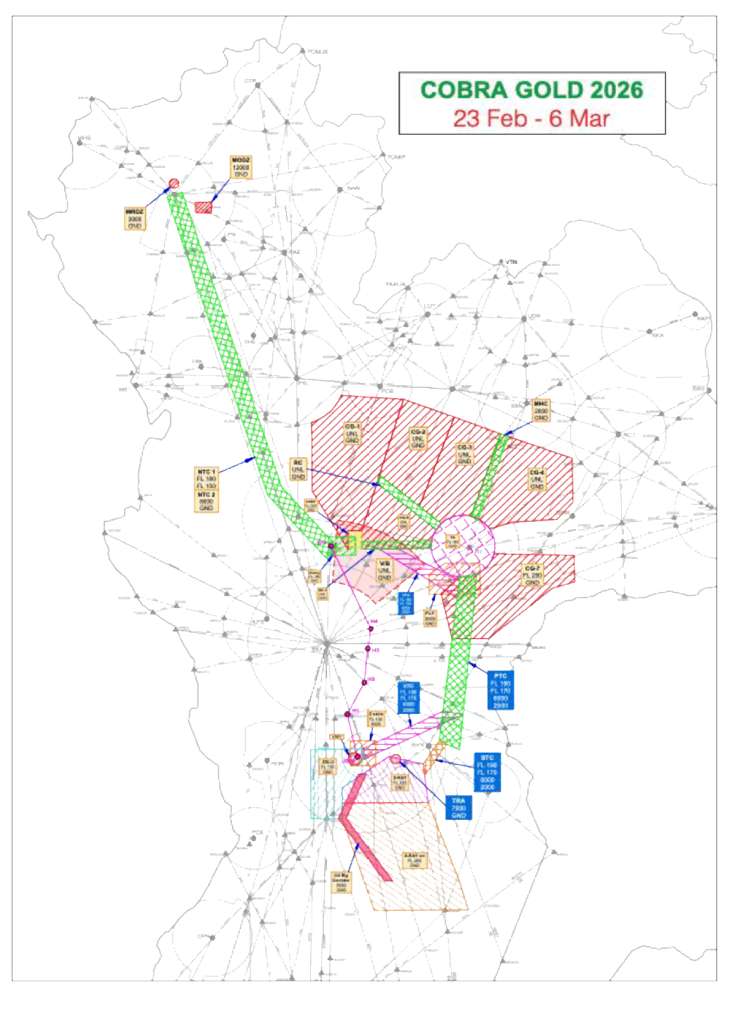
Joint military exercise named COBRA GOLD 2026 will take place within the Bangkok FIR from 23 February - 6 March 2026. Details are as follows.

2  EXERCISE AREAS

The following area will be designated as a Temporary Reserved Area (TRA), an airspace temporarily reserved for military air exercises, where other traffic is restricted from transiting.

Area (boundary)Vertical limitsPeriod of activity
2.1

Charlie 1 (CG-1)

Area bounded by a line joining the following points:
145500N1005000E, 153300N1002700E, 161731N1002700E, then along a 30 NM arc counterclockwise from the Phitsanulok VOR (PSL) (164613.34N1001728.70E) to 163454N1004626E, 163200N1012700E, 150700N1005900E, 150700N1005000E then back to the point of origin.

GND - UNL

23 February - 6 March 2026 Between 0100 - 1000 UTC (Except Saturday and Sunday)
2.2

Charlie 2 (CG-2)

Area bounded by a line joining the following points:
163200N1012700E,162000N1020000E, 152220N1013630E, 154255.80N1011046.48E then back to the point of origin.

GND - UNL

23 February - 6 March 2026 Between 0100 - 1000 UTC (Except Saturday and Sunday)
2.3

Charlie 3 (CG-3)

Area bounded by a line joining the following points:
162000N1020000E, 160840N1023000E, 151528.42N 1020944.40E, then along a 20 NM arc counterclockwise around the Khorat TACAN (KRT) (145606.00N1020421.80E) to 151100.70N1015032.93E, 152220N1013630E then back to the point of origin.

GND - UNL

23 February - 6 March 2026 Between 0100 - 1000 UTC (Except Saturday and Sunday)
2.4

Charlie 4 (CG-4)

Area bounded by a line joining the following points:
160840N1023000E, 155200N1031600E, 152331N1031602E, 151234N1030528E,
151100N1023600E, 150656.88N1022144.04E then along a 20 NM arc counterclockwise from the Khorat TACAN (KRT) (145606.00N1020421.80E) to 151528.42N1020944.40E then back to the point of origin.

Excluding: Buri Ram Terminal Control Area (TMA) Buri Ram Approach Freq 125.55 MHz

GND - UNL

23 February - 6 March 2026 Between 0100 - 1000 UTC (Except Saturday and Sunday)
Area (boundary)Vertical limitsPeriod of activity(Except Saturday and Sunday)
 

NOTE:

Buri Ram TMA

The airspace enclosed by the following boundaries beginning at a point 152840N1033030E then clockwise along 20 NM arc from BRM DVOR/DME (151422.43N1031531.59E) to 151633N1033522E and then clockwise along 25 NM arc radius centred on SURIN ARP (145209.40N1032920.00E) to a point 145132N1035548E and then direct to a point 144953N1035055E and then clockwise along 20 NM arc radius centred on SURIN ARP (145209.40N1032920.00E) to a point 143830N1031416E and then direct to a point 143652N1030924E then clockwise along 25 NM arc radius centred on SURIN ARP (145209.40N1032920.00E) to a point 145620N1030434E then direct to a point 145300N1024000E and then counterclockwise along 35 NM arc from KORAT TACAN (KRT) (145606.00N1020421.80E) to a point 151135N1023700E then direct to a point 151224N1030024E then clockwise along 15 NM arc from BRM DVOR/DME (151422.43N1031531.59E) to a point 152918N1031751E then direct to 154407N1032620E and counterclockwise along 30 NM arc from ROT DVOR/DME (160700.59N1034619.45E) then direct to starting point.

Vertical limits: 11000 ft / 2000 ft AGL

2.5

Charlie 7 (CG-7)

Area bounded by a line joining the following points:

143609.97N1020159.36E then along a 20 NM arc counterclockwise from the Khorat TACAN (KRT) (145606.00N1020421.80E) to 145100.39N1022419.42E, 144900N1031600E, 143144N1031602E, 142800N1030145E, 135556N1021953E, 135605N1015626E
then back to the point of origin.

GND - UNL

23 February - 6 March 2026 Between 0100 - 1000 UTC (Except Saturday and Sunday)
2.6

Charlie 8 (CG-8)

Area bounded by a line joining the following points:

153740N1010915E, 150700N1014715E then along a 20 NM arc counterclockwise around the Khorat TACAN (KRT) (145606.00N1020421.80E) to 145500N1014400E, 145500N1005900E, 150700N1005900E then back to the point of origin.

GND - UNL

23 February - 6 March 2026 Between 0100 - 1000 UTC (Except Saturday and Sunday)
2.7

Recovery Corridor

A 5 NM wide corridor bounded by a line joining points
150700N1014715E, 151055N1015040E, 154245N1011100E, 153740N1010915E then back to the starting point.

The primary purpose of this corridor is to provide a safe departure/recovery route for aircraft transiting
to and from areas CG-1, CG-2, CG-3, and CG-8.

GND - UNL

23 February - 6 March 2026 Between 0100 - 1000 UTC (Except Saturday and Sunday)
2.8

Recovery Corridor 1 (RC-1)

A 5 NM wide corridor bounded by a line joining 145500N1005900E, 150000N 1005900E, 150000N1014400E, 145500N 1014400E
Then back to the starting point.

The primary purpose of this corridor is to provide a safe departure/recovery route for aircraft transiting to and from Between Transition Area (TA) and Chandy Range.

GND - UNL23 February - 6 March 2026 Between 0100 - 1000 UTC (Except Saturday and Sunday)
Area (boundary)Vertical limitsPeriod of activity(Except Saturday and Sunday)
2.9

Transition Area (TA)

A circle of 20 NM radius centred on Khorat TACAN (KRT) (145606.00N1020421.80E).

The primary purpose of TA is to provide a safe transition for aircraft transiting to/from one exercise area to another. Aircraft in transition area shall maintain the appropriate level conform to direction of flight.

NOTE:

The airspace will be available for civil aircraft subjected to prior coordination with “Combined Live Fly Cell Unit” Phone: +668 4251 9741

GND - FL160

23 February - 6 March 2026 Between 0100 - 1000 UTC (Except Saturday and Sunday)
2.10

Victor Blue / Aggressor Area

A restricted area has been established to facilitate flying operations for His Majesty the King of Thailand. The VICTOR BLUE airspace lines between the Bangkok VOR/DME (BKK) (135336.80N1003546.30E) 005 and 050 radials from 40 NM to 80 NM arc.

GND - UNL

23 February - 6 March 2026 Between 0100 - 1000 UTC (Except Saturday and Sunday)
2.11

PHU LAM YAI RANGE (PLY)

Area bounded by a line joining the following points:

142500N1014200E, 143800N1014200E, 144500N1015200E, 144500N1021500E, 142500N1021500E
then back to point of origin.

GND - 8,000 ft MSL

23 February - 6 March 2026 Between 0100 - 1000 UTC
2.12

X-Ray

Area bounded by a line joining the following points:

124000N1011500E, 123500N1013700E, 121000N1014000E, 121000N1004500E, 122000N1004500E
then back to point of origin.

GND - FL220

23 February - 6 March 2026 Between 0100 - 1000 UTC
2.13

X-Ray Extended

Area bounded by a line joining the following points:

121000N1014000E, 112000N1015900E, 110000N1020500E, 110000N1010500E, 120000N1004500E, 121000N1004500E
then back to point of origin.

Caution: X-Ray Extended will not be scheduled for exercise flights on Tuesdays, Wednesdays, and Fridays from 1430-1630 Local Time. This is to allow scheduled civilian air traffic to transit the area.

GND - FL260

23 February - 6 March 2026 Between 0100 - 1000 UTC
2.14

Zulu

Area bounded by a line joining the following points:

124500N1002500E, 124500N1005800E, 122843N1005800E, 122000N1004500E, 120000N1004500E, 120000N1002500E
then back to the point of origin.

ZULU LOW
SFC - 6,000 ft MSL

ZULU HIGH
6,000 ft MSL - FL130
23 February - 6 March 2026 Between 0100 - 1000 UTC
2.15

Zulu Extra

Area bounded by a line joining the following points:

125031N1005031E, 125024N1010652E, 123408N1010644E, 123415N1005023E
then back to the point of origin.

6,000 ft MSL - FL130

23 February - 6 March 2026 Between 0100 - 1000 UTC
2.16

Chandy Range

Chandy Range is located on KRT R-274/68 DME.

Area bounded by a line joining the following points:

150700N1005900E, 150700N1005000E, 145500N1005000E, 145500N1005900E
then back to the point of origin.

GND - FL240

23 February - 6 March 2026 Between 0100 - 1000 UTC
2.17

Baan Dilang

Area bounded by a line joining the following points:

150301N1003713E, 150302N1005447E, 145059N1005448E, 145057N1003714E
then back to the point of origin.

GND - FL150

23 February - 6 March 2026 Between 0100 - 1000 UTC
2.18MRDZ
A circle of 3 NM radius centered on
18 53.067N098 57.238E
GND - 3,000 ft MSL 23 February - 6 March 2026 Between 0100 - 1000 UTC
2.19MODZ
Area bounded by a line joining the following points:
184107N0992216E, 183350N0992204E, 183408N0991142E, 184040N0991125E
then back to the point of origin.
GND - 12,000 ft MSL
(FL120)
23 February - 6 March 2026 Between 0100 - 1000 UTC

3  TRANSITION CORRIDORS

The following area will be designated as a Temporary Reserved Area (TRA), an airspace temporarily reserved for military air exercises, where other traffic is restricted from transiting.

Area (boundary)Vertical limits

Period of activity

3.1

Primary Transition Corridor (PTC)

Area bounded by a line joining the following points:

143609.97N1020159.36E then along a 20 NM arc counterclockwise from Khorat TACAN (KRT) (145606.00N1020421.80E) to 143755.06N1021306.26E, 124346.84N1020027.68E, 124957.01N1014724.86E then back to the point of origin.

2,000 - 6,000 ft MSL
and FL170 - FL190

23 February - 6 March 2026 Between 0100 - 1000 UTC
3.2

U-Tapao Transition Corridor (UTC)

Area bounded by a line joining the following points:

124500N1005800E, 123800N1005800E, 130700N1020300E, 130900N1015000E
then back to the point of origin.

NOTE: Exercise aircraft departed from U-Tapao must cross the BUT VOR (124000.02N1010001.71E)
R-065 at 20 DME at/or above FL130.

2,000 - 6,000 ft MSL
and FL170 - FL190

23 February - 6 March 2026 Between 0100 - 1000 UTC
3.3

Chandy Transition Corridor (CTC)

Area bounded by a line joining the following points:

145500N1011000E, 145500N1012200E, 143342N1020138E, 142238N1020000E
then back to the point of origin.

2,000 - 6,000 ft MSL
and FL170 - FL190

23 February - 6 March 2026 Between 0100 - 1000 UTC
3.4

Sierra Transition Corridor (STC)

Area bounded by a line joining the following points:

124957.01N1014724.86E,124744.85N1015204.53E, 122724.74N1013754.64E,123500.00N1013700.00E,then back to the point of origin.

2,000 - 6,000 ft MSL
and FL170 - FL190

23 February - 6 March 2026 Between 0100 - 1000 UTC
3.5North Transition Corridor (NTC)

A corridor 5 NM either side (10NM width) from the line joining following points:
LB, 153258.56N1000248.38E, BEKOD, ENBAT, CMA
GND - 8,000 ft MSL
and FL150 - FL180
23 February - 6 March 2026 Between 0100 - 1000 UTC
3.6

MEDEVAC Helicopters Corridor (MHC)

Area bounded by a line joining the following points:

151528.42N, 1020944.40E, 160840N1023000E, 160654.78N 1023451.84E and 151223.76N 1021404.38E
then back to the point of origin.

GND – 2,000 ft AGLUpon request between
23 February - 6 March 2026
3.7

Oil Rig Corridor (ORC)

Area bounded by a line joining the following points:

122843N1005530E, 122843N1010030E, 120000N1004730E,111920N1011645E,
111920N1011145E, 120000N1004230E, 122843N1005530E
then back to the point of origin.

ALT 3,000 - 5,000 ft MSL23 February - 6 March 2026 Between 0100 - 1500 UTC
3.8

Helicopter Transition Route

The exercise Helicopter or VFR aircrafts departed from USS Boat, from U-Tapao airport, Chuck Samed Port to Lop - Buri and vice versa for deployment and re-redeployment purpose shall follow the VFR route.

Helicopter or VFR aircrafts Departed from USS Boat, and Chuck Samed Port shall Contact U-Tapao APP 119.7 MHz before proceeding to the following route.

Route:

Chuck Samed Port (Cross 270R 5 NM From BUT VOR for Avoid VTR79) DCT

H1 (Koh Srichang) DCT
H2 (Bang Pakong) DCT
H3 (Bang Nam Praew) DCT
H4 (Bang Look Sua) DCT
Saphan Nak Airfield

Altitude not above 1,000 Feet AGL if request higher
Contact BKK APP 125.8 MHz

Not above 1,000 ft AGL23 February - 6 March 2026 Between 0100 - 1000 UTC
 Coordinates:
H1 Koh Srichang130745N1004840E
H2 Bang Pakong132809N1005945E
H3 Bang Nam Praew135014N1010210E
H4 Bang Look Sua140310N1010404E
SPN Saphan Nak Airfield145700N1003900E

4  WARNING AREA

4.1 Flying over the Gas Separation Plant in Rayong (Ban Map Ta Phut) is hazardous. All aircraft are recommended to avoid area starting from 1241.2N10108.0E then clockwise along an arc of 2 NM radius from 1243.0N10109.0E to 1243.0N10111.0E then direct to 1238.5N10111.0E from this point make an arc of 5 NM radius from 1243.0N10109.0E clockwise to 1238.2N10108.0E then direct to the starting point, altitude 2000 ft MSL.
4.2 Flying over Tempo Restricted Area (TRA) (Mueang district Rayong province) is prohibited. Aircraft will avoid flying within 3 NM radius centred on point 123823N1011931E, (47P QP 52579 98416) ALT GND - ALT 7000 ft MSL.

5  LIST OF CLOSED ATS ROUTES

During the exercise period, the following ATS routes will be closed.

ATS RouteClosed SegmentClosed LevelsRemarks from ATC unit
A464SEMBO - CMAMFA - FL080
FL150 - FL180
Flights intended to operate into NTC area are subjected to ATC instructions or prior coordination with “Live Fly Cell”.
W9/Y28PEPLI - BKKMFA - FL080
FL150 - FL180
Y7PAKMO - BKKMFA - FL080
FL150 - FL180
Y26BEBUV - CMAMFA - FL080
FL150 - FL180
Y27UGUVO - PAKMOMFA - FL080
FL150 - FL180
Y32ELDAL - KIMETMFA - FL080
FL150 - FL180
Y33BEBUV - IBIRIMFA - FL080
FL150 - FL180
W10VUTHI - BLAFFMFA - FL080
FL150 - FL180
W26TAK - IGPOPMFA - FL080
FL150 - FL180
G473MAKAS - PSLFL150 - FL180
R202BIGVO - PAEFL150 - FL180
W15CMA - KABMUMFA – A120 (FL120)-
B346BKK - PCBMFA – FL460-
W21BKK - CMPMFA – FL460-
W39NOBER - PCB MFA – FL460-
R474BKK - CMPMFA – FL460-
Y1UDN - PIPOBMFA – FL460-
Y2KKN - PIPOBMFA – FL460-
W8TL - KRTMFA – FL460-
W6/Y23KRT - KKNMFA – FL460-
B460KRT - BODURMFA – FL460-
W1/Y20RAMEI - UBLOD MFA – FL190 Flights intended to operate into TA and CTC area are
subjected to ATC instructions or prior coordination with “Live Fly Cell”.
A1SELKA - SANOTMFA - FL200ACFT DEP from VTBD, VTBS shall cross 70 NM FM BKKFL210 or above.
W42BERLU - RYNFL170 - FL190-
G474/L880DOSBU - OMUROFL170 - FL190ACFT DEP/ARR to VTBD/VTBS shall cross 70 NM FM BKK FL200 or above.
M633TUPGO - OLTUMFL170 - FL190ACFT ARR to VTBD/VTBS shall cross 70 NM FM BKK FL200 or above.
B204GOMES - AGEDOFL170 - FL190-
R468/N506GOMES - BOKAKFL170 - FL190-
P629VAPVU - DOLNIFL170 - FL190-
B205RYN - BOKAKFL170 - FL190-
N891DOLNI - ANOBOFL170 - FL190ACFT DEP/ARR to VTBD/VTBS shall cross 65 NM FM BKK FL200 or above or FL160 or below.
Y11BUT - ANBUXMFA - FL260NOT AVBL FOR FLT DEP FM VTBD, VTBS AND VTBU
Y12ALUMO – ALEMIMFA - FL260ACFT ARR to VTBD/VTBS shall cross 65 NM FM BKK FL200 or above and to cross ALEMI FL220 or above.
ALEMI - DOLNIFL170 - FL190
M904KIGOB - BUTMFA - FL130
FL170 - FL190
NOT AVBL FOR FLT DEP FM VTBD, VTBS AND VTBU
BUT - SIRATMFA - FL260
R334RYN – 20 NM
Southeast of RYN
FL170 – FL190-
W33RYN - TRTFL170 - FL190ACFT DEP/ARR from TRAT TMA on W33 below FL260
expect radar vectored by ATC to avoid traffic in X-ray
Extended area.
TRT - SURIXMFA - FL260
A464/M751/W19GUTSO - REGOSMFA - FL130ACFT DEP from VTBD/VTBS shall cross 65 NM FM BKK FL140 or above.
M757KASNI - ASEKUMFA - FL130
M769/Y98SURMA - LEBIMMFA - FL130-

Remark: For the details of the closure period, see item 2 Exercise Areas and item 3 Transition Corridors of this AIP Supplement.

6  CLEARANCE RESTRICTIONS AND FLIGHT PLANNING PROCEDURES

To improve safety, airspace capacity, and flight efficiency during the COBRA GOLD 2026 exercise, flights operating into the affected airspace during 23 February - 6 March 2026, between 0100 - 1000 UTC except Saturday and Sunday, must follow the clearance restrictions and flight planning procedures outlined in this AIP Supplement.

Note:
- For information not listed in this AIP Supplement, refer to the information listed in AIP ENR 1.10 FLIGHT PLANNING and/or related NOTAMs.

- For flights unable to comply with the mentioned procedure, coordinate with Live Fly Cell prior to submitting the flight plan.

6.1  For RNAV capable aircraft

6.1.1 Departure/Overfly flights from VTBD/VTBS/BKK to the following destinations/waypoints shall file flight plan as follows:
Departure/OverflyDestination/OverflyRouting
1VTBD/VTBS/BKKVTPBY27 PIBAN Y29 PSL W26
2VTUDY27 PIBAN Y29 PSL W26 CMP W21
3VTUKA1 SANOT Y15 GRASO R345 ROT Y22
4VTUIA1 SANOT Y15 GUROK DCT SKN
5VTULY27 PIBAN Y29 PSL W27
6VTUOA1 SANOT Y15 GRASO DCT BRM
7VTUWA1 SANOT Y15 GUROK DCT NKP
8VTUVA1 SANOT Y15 GRASO R345
9VLVT/VTNY27 PIBAN Y29 PSL W26 CMP W21 UDN R470
10VLLB/LPBY27 IBUBU W25 NAN R215 TOMIP
11SAGAGY27 IBUBU W25 NAN R215 TOMIP (OR)
Y27 IKISU W22 CTR A581 PONUK
12RYNSAVY27 IKISU W22 CTR A581 PONUK

Remark: All aircraft concerned are to expect radar vectoring to suit the flow of traffic and/or avoid affected airspace.

6.1.2 Arrival/Overfly flights to VTBD/VTBS/BKK from the following Departure airports /waypoints shall file flight plan as follows:
Departure/OverflyDestination/OverflyFlight Planning
1VTPBVTBDW26 GOKON Y31 PEBLI Y28 BLAFF DCT NAKON
2VTBSW26 GOKON Y31 PEBLI Y28 BLAFF DCT NORTA
3BKKW26 GOKON Y31 PEBLI Y28
4VTUDVTBDW21 CMP W26 GOKON Y31 PEBLI Y28 BLAFF DCT NAKON
5VTBSW21 CMP W26 GOKON Y31 PEBLI Y28 BLAFF DCT NORTA
6BKKW21 CMP W26 GOKON Y31 PEBLI Y28
7VTUKVTBDY22 ROT R345 GRASO Y20 UBLOD DCT ENDUU
8VTBSY22 ROT R345 GRASO Y13 RUKSA DCT EASTE
9BKKY22 ROT R345 GRASO Y20
10VTUIVTBDSKN DCT ROT R345 GRASO Y20 UBLOD DCT ENDUU
11VTBSSKN DCT ROT R345 GRASO Y13 RUKSA DCT EASTE
12BKKSKN DCT ROT R345 GRASO Y20
13VTULVTBDY31 PEBLI Y28 BLAFF DCT NAKON
14VTBSY31 PEBLI Y28 BLAFF DCT NORTA
15BKKY31 PEBLI Y28
16VTUWVTBDY23 SKN DCT ROT R345 GRASO Y20 UBLOD DCT ENDUU
17VTBSY23 SKN DCT ROT R345 GRASO Y13 RUKSA DCT EASTE
18BKKY23 SKN DCT ROT R345 GRASO Y20
19VTUVVTBDR345 GRASO Y20 UBLOD DCT ENDUU
20VTBSR345 GRASO Y13 RUKSA DCT EASTE
21BKKR345 GRASO Y20
22VTUOVTBDBRM DCT RAMBU Y20 UBLOD DCT ENDUU
23VTBSBRM DCT RAMBU Y20 RAMEI W42 PAKRI Y13 RUKSA DCT EASTE
24BKKBRM DCT RAMBU Y20
25VTN/VLVT/VLLB/LPB/SAGAGVTBDVTN R470 UDN W21 CMP W26 GOKON Y31 PEBLI Y28 BLAFF DCT NAKON
26VTBSVTN R470 UDN W21 CMP W26 GOKON Y31 PEBLI Y28 BLAFF DCT NORTA
27BKKVTN R470 UDN W21 CMP W26 GOKON Y31 PEBLI Y28
28SAVVTBDA202 GUROK DCT RAMBU Y20 UBLOD DCT ENDUU
29VTBSA202 GUROK DCT RAMBU DCT PAKRI Y13 RUKSA DCT EASTE
30BKKA202 GUROK DCT RAMBU Y20
31RYNA202 GUROK DCT RAMBU Y20 RAMEI W42

Remark: All aircraft concerned are to expect radar vectoring to suit the flow of traffic and/or avoid affected airspace.

6.2  For NON-RNAV capable aircraft

NON-RNAV capable aircraft shall operate at FL250 and below.

6.2.1 Departure/Overfly flights from VTBD/VTBS/BKK to the following destinations/waypoints shall file flight plan as follows:
Departure/OverflyDestination/OverflyFlight Planning
1VTBD/VTBS/BKKVTPBA464 BEKOD DCT PSL W26
2VTUDA464 BEKOD DCT PSL W26 CMP W21
3VTUKA1 SANOT DCT GRASO R345 ROT W5
4VTUIA1 SANOT DCT GRASO DCT GUROK DCT SKN
5VTULA464 BEKOD DCT PSL W27
6VTUOA1 SANOT DCT GRASO DCT BRM
7VTUWA1 SANOT DCT GRASO DCT GUROK DCT NKP
8VTUVA1 SANOT DCT GRASO R345
9VLVT/VTN/
VLLB/LPB/
SAGAG
A464 BEKOD DCT PSL W26 CMP W21 UDN R470
10SAVA1 SANOT DCT GRASO DCT GUROK A202
11RYNSAVW42 TOPER A1 SANOT DCT GRASO DCT GUROK A202

Remark: All aircraft concerned are to expect radar vectoring to suit the flow of traffic and/or avoid affected airspace.

6.2.2 Arrival/Overfly flights to VTBD/VTBS/BKK from the following Departure airports/waypoints shall file flight plan as follows:
Departure/OverflyDestination/OverflyFlight Planning
1VTPBVTBDW26 PSL W9 BLAFF DCT NAKON
2VTBSW26 PSL W9 BLAFF DCT NORTA
3BKKW26 PSL W9
4VTUDVTBDW21 CMP W26 PSL W9 BLAFF DCT NAKON
5VTBSW21 CMP W26 PSL W9 BLAFF DCT NORTA
6BKKW21 CMP W26 PSL W9
7VTUKVTBDW5 ROT R345 GRASO W1 UBLOD DCT ENDUU
8VTBSY22 ROT R345 GRASO Y13 RUKSA DCT EASTE
9BKKY22 ROT R345 GRASO Y20
10VTUIVTBDSKN DCT ROT R345 GRASO Y20 UBLOD DCT ENDUU
11VTBSW5 ROT R345 GRASO DCT PAKRI DCT RUKSA DCT EASTE
12BKKW5 ROT R345 GRASO W1
13VTULVTBDW27 PSL W9 BLAFF DCT NAKON
14VTBSW27 PSL W9 BLAFF DCT NORTA
15BKKW27 PSL W9
16VTUWVTBDW6 SKN DCT ROT R345 GRASO W1 UBLOD DCT ENDUU
17VTBSW6 SKN DCT ROT R345 GRASO DCT PAKRI DCT RUKSA DCT EASTE
18BKKW6 SKN DCT ROT R345 GRASO W1
19VTUVVTBDR345 GRASO W1 UBLOD DCT ENDUU
20VTBSR345 GRASO DCT PAKRI DCT RUKSA DCT EASTE
21BKKR345 GRASO W1
22VTUOVTBDBRM DCT RAMBU W1 UBLOD DCT ENDUU
23VTBSBRM DCT RAMBU W1 RAMEI W42 PAKRI DCT RUKSA DCT EASTE
24BKKBRM DCT RAMBU W1
25VTN/VLVT/VLLB/LPB/SAGAGVTBDVTN R470 UDN W21 CMP W26 PSL W9 BLAFF DCT NAKON
26VTBSVTN R470 UDN W21 CMP W26 PSL W9 BLAFF DCT NORTA
27BKKVTN R470 UDN W21 CMP W26 PSL W9
28SAVVTBDA202 GUROK DCT RAMBU W1 UBLOD DCT ENDUU
29VTBSA202 GUROK DCT RAMBU W1 RAMEI W42 PAKRI DCT RUKSA DCT EASTE
30BKKA202 GUROK DCT RAMBU W1
31RYNA202 GUROK DCT RAMBU W1 RAMEI W42

Remark: All aircraft concerned are to expect radar vectoring to suit the flow of traffic and/or avoid affected airspace.

7  ACTION IN EVENT OF EMERGENCY

In case of civil and non-exercise military aircraft experiencing and emergency that make it necessary to enter an active exercise area should immediately advise one of the following agencies:

7.1  Bangkok Area Control Centre (BACC) sector concerned ATS units are as follows:

UnitFrequency
BACCSECTOR 1N124.5 MHz or 256.3 MHz
SECTOR 2N126.5 MHz
SECTOR 3N128.1 MHz or 263.8 MHz
SECTOR 4N120.95 MHz
SECTOR 5N132.1 MHz or 268.5 MHz
SECTOR 6N133.1 MHz or 285.3 MHz
SECTOR 1S120.5 MHz or 256.6 MHz
SECTOR 2S118.35 MHz
SECTOR 3S125.7 MHz or 268.5 MHz
SECTOR 4S133.9 MHz
SECTOR 5S135.5 MHz or 285.5 MHz
SECTOR 6S123.95 MHz or 265.9 MHz
BANGKOK APPROACH

APP North 133.4 MHz

APP East 119.1 MHz, 122.35 MHz or 262.5 MHz

APP West 124.35 MHz, 125.2 MHz or 262.5 MHz

PHITSANULOK APPROACH120.7 MHz or 284.0 MHz
KAMPHAENG SAEN APPROACH127.75 MHz or 347.2 MHz
OSCAR CONTROL127.0 MHz or 331.3 MHz
FOCAL CONTROL127.0 MHz or 331.3 MHz
U-TAPAO APPROACH

119.7 MHz or 273.3 MHz (Primary)

134.5 MHz or 238.3 MHz (Secondary)

U-TAPAO TOWER118.3 MHz or 227.0 MHz
KHORAT APPROACH129.75 MHz or 349.0 MHz
KHORAT TOWER122.2 MHz or 240.5 MHz
KHON KAEN APPROACH123.4 MHz or 240.0 MHz
BURI RAM APPROACH125.55 MHz
7.2 If unable to contact BACC or concerned ATS units, an aircraft should contact OSCAR Control on Freq 127.0 MHz or any other GCI facilities. COBRA GOLD 2026 aircraft experiencing an emergency and unable to contact their appropriate control agencies shall contact OSCAR Control or any other GCI facility on Freq 331.3 MHz, 127.0 MHz or guard Freq 243.0 MHz and 121.5 MHz. During exercise period all VTD area that are overlapped by COBRA GOLD 2026 areas will be not active. Aircraft not associated with COBRA GOLD 2026 exercise wishing to fly through the areas should contact "Live Fly Cell" on phone number +668 4251 9741or "OSCAR Control" on phone number +662 534 4731 to get permission before filing the flight plan.

8  AIR TRAFFIC FLOW MANAGEMENT DURING COBRA GOLD 2026 PERIOD

In response to the capacity constraint caused by the Joint Military Air Exercise "COBRA GOLD 2026" the following ATFM measures will be implemented:

8.1  The Ground Delay Program (GDP) may be implemented during the traffic congestion period. ATFM procedure is published in AIP Thailand ENR 1.9

8.2  Temporary Flight Level orientation scheme

Flights operating on the following routes are requested to use the following flight level orientation scheme:

8.2.1 Northbound flight from VTBD, VTBS, BKK via A464 (Portion BKK CMA) Y26, or Y27 – Odd FL

and flight depart from VTPI, VTBL, VTBH, VTPP via W9.

8.2.2 Southbound flight to VTBD, VTBS, BKK via Y7, Y28 or W9 or other airways joining W9. – Even FL

9  POINT OF CONTACTS

UnitContact Details
Live Fly Cell of Cobra Gold 2026Sqn.Ldr. Pornwisanu Rumruay
Mobile: +668 4251 9741
E-mail: [email protected]
[email protected]

Bangkok Air Traffic Flow Management Unit

Phone: +662 287 8024

E-mail: [email protected]

Website: http://atfm.aerothai.aero

AFTN: VTBBZDZX

Airspace Management Cell (Thailand)

For AUP/UUP

Phone: +662 307 2132

Mobile: +666 1402 4966

E-mail: [email protected]

Website: www.thaicmac.aerothai.aero

10  VALIDITY

This AIP Supplement will remain current until 6 March 2026. Any change to this supplement will be promulgated by NOTAM.

11  EXERCISE AREA MAP