GEN 2.3 CHART SYMBOLS
1. Aerodromes
1.1 Charts other than approach charts
| Civil (land) |
 |
| Civil (water) |
 |
| Joint civil and military (land) |
 |
| Joint civil and military (water) |
 |
| Military (land) |
 |
| Military (water) |
 |
| Emergency aerodrome or aerodrome with no facilities |
 |
| Sheltered anchorage |
 |
| Heliport |
 |
1.2 Approach charts
| The aerodrome on which the procedure is based |
 |
| Aerodromes affecting the traffic pattern on the aerodrome on which the procedure is based |
 |
1.3 Aerodrome charts
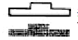
| Hard surface runway |
 |
| Unpaved runway |
 |
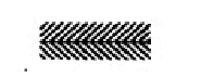
| Stopway |
 |
2. Aerodrome Installations and lights
| Aerodrome reference point (ARP) |
 |
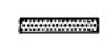
| Taxiways and parking areas |
 |
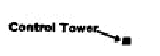
| Control tower |
 |
| Point light |
 |
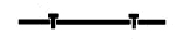
| Barrette |
 |
| Marine light |
 |
| Obstacle light |
 |
| Aeronautical ground light |
 |
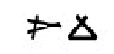
| Wind direction indicator (lighted) |
 |
| Wind direction indicator (unlighted) |
 |
| Landing direction indicator (lighted) |
 |
| Landing direction indicator (unlighted) |
 |
3. Miscellaneous
| Highest elevation on chart |
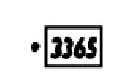 |
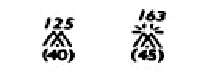
| Obstacles |
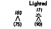 |
|
Group obstacles Note: Numerals in italics indicate elevation of top of obstacle above sea level. Upright numerals in parentheses indicate height above specified datum. |
 |
| Restricted airspace (prohibited, restricted or danger areas) |
 |
| Common boundary of two areas |
 |
| Transmission line or overhead cable |
 |
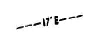
| Isogonal |
 |