ENR 1.2 VISUAL FLIGHT RULES
1. VISUAL FLIGHT RULES IN BANGKOK FIR
1.1 General
1.2 VFR flight in BANGKOK FIR
1.3 VFR flight in controlled airspace
1.4 VFR flights outside controlled airspace
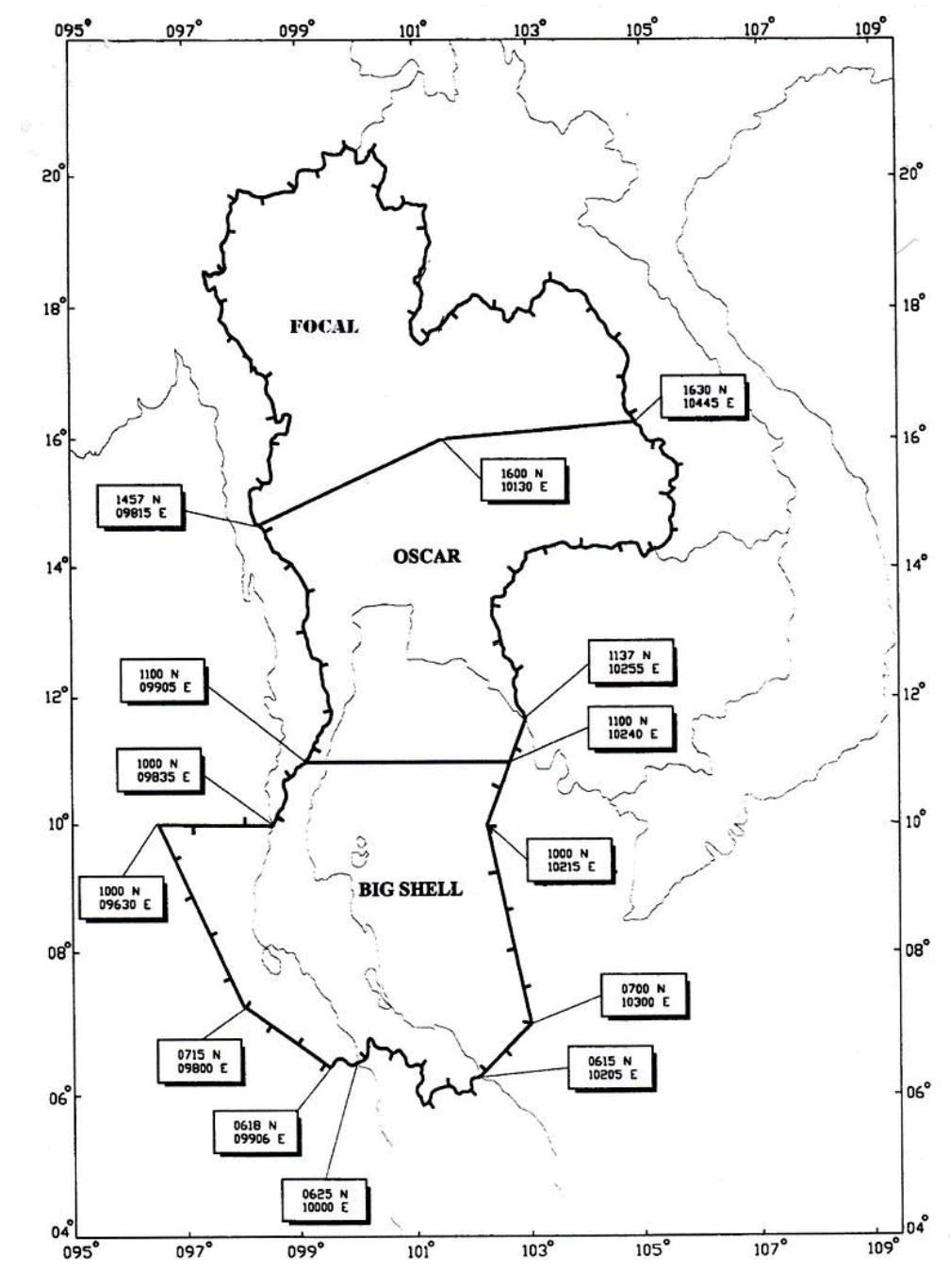
All VFR flights outside controlled airspace must contact authorities concerned on frequency 127.0 MHz or 331.3 MHz and prepare to stand by.
Details of call signs and responsible areas of authorities concerned are as follows: (see page ENR 1.2-2)
| CALL SIGNS | RESPONSIBLE AREAS |
|---|---|
| FOCAL | An area bounded by a line joining the following points: 1457N09815E northward along the nation border to 1630N10445E, 1600N10130E then back to the point of origin. |
| OSCAR | An area bounded by a line joining the following points: 1457N 09815E southward along the nation border to 1100N09905E, 1100N10240E, 1137N10255E northward along the nation border to 1630N10445E, 1600N10130E, then back to the point of origin. |
| BIG SHELL | An area bounded by a line joining the following points: 1100N09905E, 1100N10240E, 1000N10215E, 0700N10300E, 0615N10205E westward along the nation border to 0625N 10000E, 0618N09906E, 0715N09800E, 1000N09630E, 1000N 09835E northward along the nation border, then back to the point of origin. |
The aforementioned regulations are to ensure the effectiveness of Air Traffic Services and to improve safety standard.
RESPONSIBLE AREAS OF AUTHORITIES CONCERNED

2. VFR OPEPATING IN CONTROL ZONE
2.1 Introduction
2.2 Procedure
2.3 VFR flight
Unless otherwise specifically authorized, VFR flights will NOT be permitted to land/take-off at any airport when conditions as reported to Aerodrome/Approach Control, by an authorized ground observer are LESS than;
Ground visibility 5 km; or
Ceiling 450 m (1 500 feet)
Authorization may be granted by ATC for special VFR flights, to land/take-off at any airport under conditions LESS than (3.1) above but NOT LESS than;
Ground visibility 1 500 m
as reported to Aerodrome/Approach Control, by an authorized ground observer
VFR flights to land/take-off at any airport shall NOT be authorized to operate between sunset and sunrise, or such other period between sunset and sunrise, unless by pre-arrangement and authorized by The Civil Aviation Authority of Thailand.
VFR flights within the CTR shall be conducted so that the aircraft maintain flight visibility and distance from cloud EQUAL TO or GREATER THAN those specified in ICAO Annex 2, Chapter 3, table 3-1;
| Flight visibility |
|
| Distance from cloud |
|
2.4 Special VFR flight
2.5 Radio communication failure
Join the traffic pattern of the landing runway by conform to the height for the type of aircraft, then make a low approach along the runway at 500 feet above the terrain, rocking wings of the aircraft until it reaches the end of the runway; and
Re-enter downwind leg and observe light signals from the control tower.
Join the traffic pattern of the landing runway by conform to the height for the type of aircraft, then make a low approach along the runway at 500 feet above the terrain and blinking the landing light until it reaches the end of runway; and
Re-enter downwind leg and observe mobile control and/or control tower for light signals on base leg and final approach.
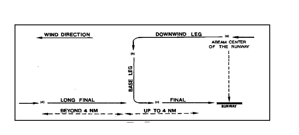
2.6 Aerodrome traffic circuit and visual circuit reporting procedure
Jet and Prop-jet 1 500 feet;
Conventional 1 000 feet;
Light aircraft 600 feet; and
Helicopter 500 feet.
Remark: If true airspeed is less than 130 knots, aircraft is considered a light aircraft

Downwind
Aircraft shall report "Downwind" abeam centre of the runway;
Base leg
Aircraft shall report "Base Leg" on completion of the turn on to base leg;
Final
Aircraft shall report "Final" after completion of the turn on to final approach, not more than 4 NM from the approach end of the runway; and
Long Final
Aircraft flying a straight-in approach shall report "Long Final" 8 NM from the approach end of the runway and "Final" when at 4 NM
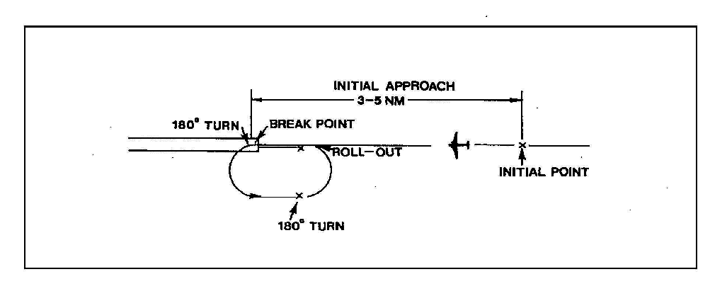
2.7 Overhead approach pattern and procedure

Initial approach point, military aircraft shall report "Initial" after established the extended runway centre line between 3 to 5 NM; and
Break point, military aircraft shall report "Break" at the approach end of the runway. If required for traffic of other reasons, the aircraft may be asked to report "Break" at the specified point (i.e. mid field or departure end of runway).
2.8 Use of runway
2.9 Closure of aerodrome
When the surface of the landing area is not suitable (e.g. soft surface or hazardous obstruction on the manoeuvring area); or
At such other times and in conditions specified by
3. VFR OPERATING AT UNCONTROLLED AERODROME
3.1 General
3.2 Procedure
3.2.1 Arriving aircraft
3.2.2 Departing aircraft
3.2.3 Aircraft operating at altitudes used normally by arriving and departing aircraft
3.2.4 Self-Announce Position and Intentions
3.2.4.3.1 Arriving Aircraft
(AIRPORT NAME) TRAFFIC, HOTEL SIERRA DELTA CHARLIE ALFA, (POSITION), (ALTITUDE), LANDING, (AIRPORT NAME)
(AIRPORT NAME) TRAFFIC, HOTEL SIERRA DELTA CHARLIE ALFA, ENTERING DOWNWIND RUNWAY TWO ONE, FULL STOP, (AIRPORT NAME)
(AIRPORT NAME) TRAFFIC, HOTEL SIERRA DELTA CHARLIE ALFA, CLEAR OF RUNWAY TWO ONE, (AIRPORT NAME)
3.2.4.3.2 Departing Aircraft
(AIRPORT NAME) TRAFFIC, HOTEL SIERRA DELTA CHARLIE ALFA, (LOCATION ON AIRPORT), TAXIING TO RUNWAY ZERO THREE, (AIRPORT NAME)
(AIRPORT NAME) TRAFFIC, HOTEL SIERRA DELTA CHARLIE ALFA, DEPARTING RUNWAY ZERO THREE, DEPARTING THE PATTERN TO THE SOUTH, CLIMBING TO (ALTITUDE), (AIRPORT NAME)