1.1 General
1.1.1 A GPS Receiver Autonomous Integrity Monitoring (RAIM) Prediction Service is available either through the internet or NOTAM for pre-flight planning.
1.1.2 Aeronautical Radio of Thailand Ltd (AEROTHAI) has contracted NAVBLUE Ltd. to provide RAIM prediction for Bangkok Flight Information Region (BKK FIR). This service will assist pilots planning to use GPS as a primary means navigation aid.
1.1.3 In order to reduce the number of RAIM Prediction NOTAM to be issued per day, with effect from 1 September 2018, for each aerodrome with GNSS procedures, the NOTAM Office will issue the GPS RAIM NOTAM only in case that there is one or more predicted GPS RAIM outages at the aerodrome. If there is no predicted outage, the NOTAM will no longer be issued.
1.2 GPS RAIM Prediction Overview
1.2.1 RAIM is a software algorithm that is available in some GPS receivers which gives an indication if the position solution given by the GPS receiver is okay to use.
1.2.2 It is okay to use GPS if the position solutions (latitude, longitude and altitude) worked out from any four of at least five or more GPS satellites all fall within a pre-defined tolerance. If the solution falls outside this tolerance then a RAIM warning is given which is indicated on the receiver. This means that the accuracy of the position on the receiver cannot be guaranteed at that point in time and so it is advisable not to use the GPS for navigation until this warning disappears.
1.2.3 The RAIM availability (or ability of a GPS receiver to provide a RAIM warning) is dependent on the number of satellites available or in view by the GPS receiver.
1.2.4 If there are less than five satellites at any point in time at some location then this is identified as a ‘RAIM hole’ (or RAIM unavailability).
1.2.5 It is basically a function of the geometry of the GPS satellites overhead of the receiver. Additionally, some satellites may have been taken out for ‘maintenance’ by the owners of the GPS constellation - the U.S. Department of Defense. The RAIM prediction provided by some receivers does not take this into account and that is where the RAIM Prediction Service comes in to compensate for this shortfall.
1.2.6 Baro-aiding for RAIM effectively allows the GPS receiver to take into account altitude information from the aircraft altimeter. This improves the availability since the additional altitude information provided by baro-aiding effectively acts as an additional satellite. An advantage when there may be limited satellite visibility in some locations due to terrain or GPS satellite constellation geometry.
1.3 RAIM Outage Information
1.3.1 The RAIM Prediction Service will provide prediction for locations with a published GPS approach as well as some locations as a check of RAIM coverage over other parts of the country. Further locations can be added as more new GPS procedures are developed.
1.3.2 The system providing the GPS RAIM Prediction Service is located in the UK and is owned and maintained by NAVBLUE Ltd.
1.3.3 RAIM Outage data for all locations in the database will be computed once per day or when a satellite outage NOTAM has been received. The computation is for the following 72-hour period.
1.4 Accessing GPS RAIM Prediction Service Information
1.4.1 Pilots can request pre-flight briefing RAIM availability information from the NETRA RAIM Prediction Service website or receive NOTAMs via AFTN.
1.4.2 Accessing RAIM availability information using the website is the easiest method of obtaining RPS information providing you have a PC and internet access. This information can be found at:
http://www.netra.aero.
Register as a new user if necessary.
Select the Tools you wish to use (Status, Aerodrome, Route, and Region).
1.4.3 The Constellation Status tool presents a view of the GPS satellite constellation based on the latest almanac and NANUs (Notice Advisory to Navigation Users) issued by the US Coast Guard.
The Constellation Status tool presents the number of operational satellites in the GPS constellation based on the information current at the time of viewing. The almanac used and NANUs that affect the availability of satellites during the requested time period are also displayed.
The Constellation Status tool is configured to provide the status of the GPS constellation for a 72 hours period calculated from the midnight previous to the time at which the status request was made (times are in UTC).
1.4.4 The Aerodrome Prediction tool calculates the predicted RAIM availability for periods of 24, 48 or 72 hours for a list of user-selected aerodromes. The RAIM calculation can be configured to represent the receiver equipment, fault detection algorithm (Fault Detection (FD) or Fault Detection and Exclusion (FDE), and awareness of SA (Selective Availability):
C129 - FD/FDE - SA On/Off
C145/146 - FDE - SA Off
For most aerodrome calculations the integrity levels will be Non-Precision Approach (NPA) or Terminal. Further options that the user can select are:
Barometric aiding, ON/OFF/BOTH
Mask Angle, user configurable between -20° and +25° elevation
The calculation results show time periods of RAIM unavailability at each aerodrome, where the calculation location is the Aerodrome Reference Point (ARP). The minimum duration of RAIM unavailability is automatically selected in accordance with the selected integrity level as specified in the applicable regulatory standard.
1.4.5 The Route Prediction tool calculates the predicted RAIM availability for points along a defined route. The user can build a route via the website where each route is built up of sections which contain a number of waypoints, and can then select the integrity level and mask angle between each successive waypoint as well as the arrival time and elevation at each point.
In addition to the calculation of the route, the user can also enter a number of aerodromes for which a RAIM availability check is needed. Typically, these aerodromes would be diversion aerodromes or destination alternates.
1.4.6 In addition to the website, RAIM outage information for aerodromes with predicted RAIM outage(s) are also distributed by the NOTAM Office once per day at 0000 UTC. The computation is for the following 48-hour period for any GPS RAIM outages with the duration of 5 minutes or more.
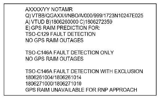
The format of the NOTAM message is as follows:
The above sample NOTAM means that “at Udon Thani Airport (VTUD) there is no GPS RAIM outage for receiver equipment TSO-129 Fault Detection or TSO-146A Fault Detection but there is however a predicted GPS RAIM outage for VTUD on 26 June 2018, from 1004 to 1014 and on 27 June 2018, from 1000 to 1010 where it states that GPS RAIM is unavailable for RNP Approach.”
The NOTAM will be issued only in case that the aerodrome has predicted GPS RAIM outage(s). If there is no predicted outage, the NOTAM will not be issued.
1.5 CONTACTS
Further information on RAIM prediction can also be obtained from NETRA RAIM Prediction Service website on the http://www.netra.aero.
Whilst every effort has been made to ensure that the content provided on this website is accurate, AEROTHAI accepts no responsibility for the timeliness, accuracy or completeness of the information provided. All content is provided “as is” with all faults, without warranty of any kind. If errors are brought to our attention, AEROTHAI will endeavour to correct them.
Email: netra.helpdesk@netra.aero
Tel: +662 287 8693
Fax: +662 287 8639