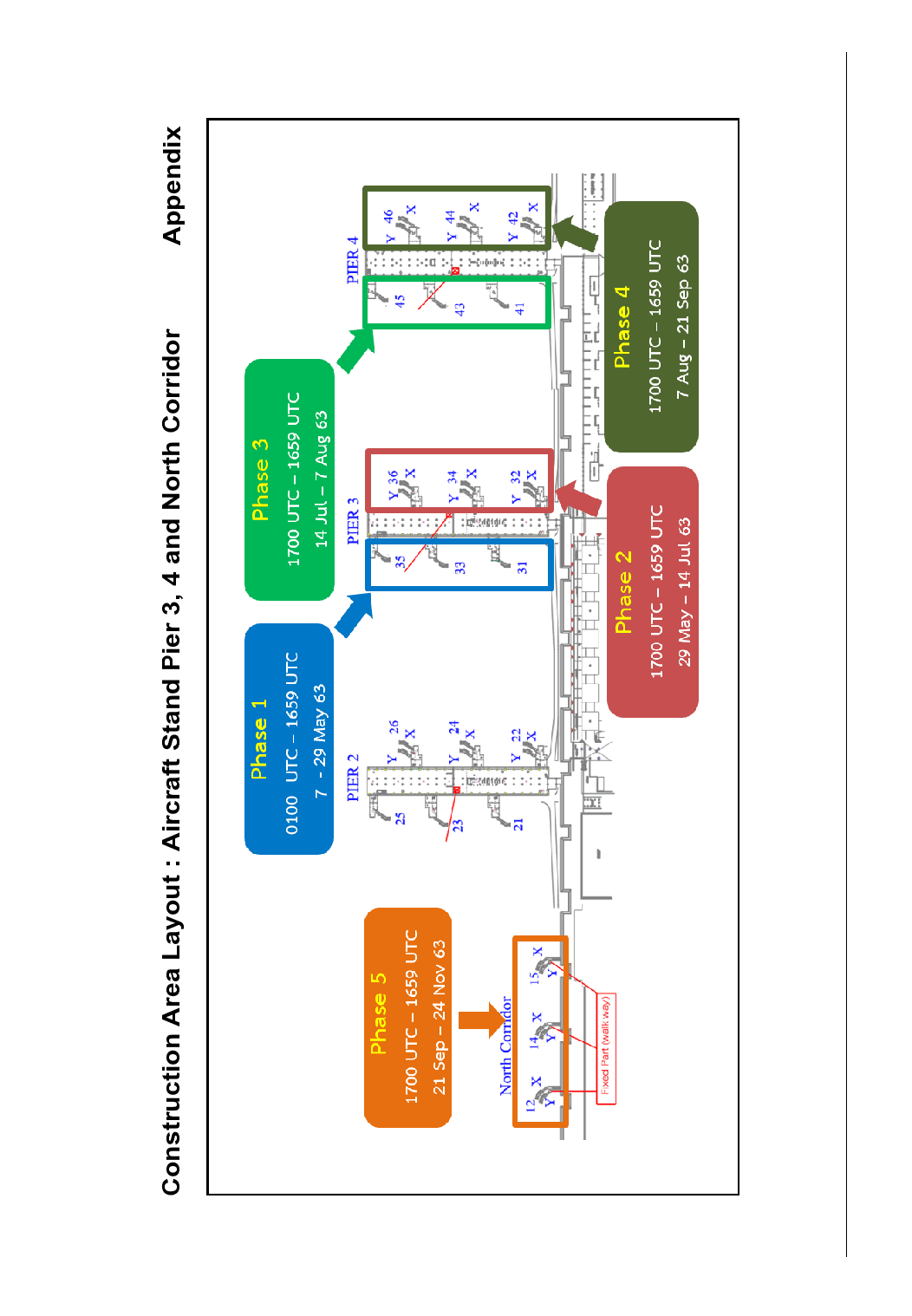
Contact

The Civil Aviation Authority of Thailand
Aeronautical Information Service Department
333/105 Lak Si Plaza, Khamphaeng Phet 6 Rd.
Talat Bang Khen, Lak Si, Bangkok 10210, Thailand

Tel: +662 568 8831

Fax: +662 576 1903

AFS: VTBAYOYX

Email: aisthai@caat.or.th

Email: ais@caat.or.th

AIP Supplement for Thailand

AIP SUP

A 19/20

Effective from 07 MAY 2020

to 24 NOV 2020

Published on 07 MAY 2020

  THE CLOSURE OF AIRCRAFT STAND PIER 3, 4 AND NORTH CORRIDOR AT DON MUEANG INTERNATIONAL AIRPORT

  INTRODUCTION

This section supplements the following portion(s) of the AIP: AD

  With effect from 7 May 2020 at 0100 UTC to 24 November 2020 at 1659 UTC, The purpose of this AIP Supplement is to inform all concerned of the closure of aircraft stand pier 3, 4 and north corridor for installation of aircraft bridge at Don Mueang International Airport.

  CONSTRUCTION AREAS AND PERIODS

Construction Area

Period (Times in UTC)

Phase 1

Aircraft Stand NR 31, 33, 35

0100 UTC – 1659 UTC

7 – 29 May 2020

Phase 2

Aircraft Stand NR 32, 34, 36

1700 UTC – 1659 UTC

29 May – 14 Jul 2020

Phase 3

Aircraft Stand NR 41, 43, 45

1700 UTC – 1659 UTC

14 Jul – 7 Aug 2020

Phase 4

Aircraft Stand NR 42, 44, 46

1700 UTC – 1659 UTC

7 Aug – 21 Sep 2020

Phase 5

Aircraft Stand NR 12, 14, 15 (North Corridor)

1700 UTC – 1659 UTC

21 Sep – 24 Nov 2020

  Construction area lay-out is shown in Appendix.

  CRANE OPERATION DETAILS

  Two mobile cranes will be operated within the construction areas, as of the following coordinates.

Aircraft Stand NR

Coordinates

Max height of Crane from AMSL

12

13°92'36.79"N 100°60'54.35"E

13°92'36.46"N 100°60'54.88"E

204 ft. (62 m.)

207 ft. (63 m.)

14

13°92'31.30"N 100°60'51.18"E

13°92'31.05"N 100°60'51.65"E

204 ft. (62 m.)

207 ft. (63 m.)

15

13°92'25.60"N 100°60'48.03"E

13°92'25.39"N 100°60'48.75"E

204 ft. (62 m.)

207 ft. (63 m.)

31

13°91'88.72"N 100°60'32.67"E

13°91'89.13"N 100°60'32.91"E

204 ft. (62 m.)

207 ft. (63 m.)

32

13°91'84.45"N 100°60'27.23"E

13°91'83.92"N 100°60'26.91"E

204 ft. (62 m.)

207 ft. (63 m.)

33

13°91'85.61"N 100°60'38.57"E

13°91'86.02"N 100°60'38.84"E

204 ft. (62 m.)

207 ft. (63 m.)

34

13°91'81.13"N 100°60'33.21"E

13°91'80.68"N 100°60'32.88"E

204 ft. (62 m.)

207 ft. (63 m.)

35

13°91'82.07"N 100°60'43.71"E

13°91'82.67"N 100°60'43.55"E

204 ft. (62 m.)

207 ft. (63 m.)

36

13°91'78.00"N 100°60'39.04"E

13°91'77.58"N 100°60'38.64"E

204 ft. (62 m.)

207 ft. (63 m.)

41

13°91'66.50"N 100°60'20.27"E

13°91'66.39"N 100°60'20.54"E

204 ft. (62 m.)

207 ft. (63 m.)

42

13°91'62.19"N 100°60'14.66"E

13°91'61.73"N 100°60'14.32"E

204 ft. (62 m.)

207 ft. (63 m.)

43

13°91'63.42"N 100°60'26.14"E

13°91'63.87"N 100°60'26.39"E

204 ft. (62 m.)

207 ft. (63 m.)

44

13°91'58.73"N 100°60'20.74"E

13°91'58.08"N 100°60'20.31"E

204 ft. (62 m.)

207 ft. (63 m.)

45

13°91'60.43"N 100°60'31.73"E

13°91'60.84"N 100°60'31.99"E

204 ft. (62 m.)

207 ft. (63 m.)

46

13°91'55.69"N 100°60'26.55"E

13°91'55.10"N 100°60'26.24"E

204 ft. (62 m.)

207 ft. (63 m.)

  MARKING AND LIGHTING FOR UNSERVICEABLE AREAS

  The construction area on closed aircraft stand will be demarcated by 0.5 meter high frangible barriers. The frangible barriers will be painted in alternate bands of red and white, and will be lighted at night and during limited visibility conditions by omnidirectional fixed red lights.

  OTHERS

  During the period of the maintenance work process, aircraft should strictly follow ATC instruction to avoid any dangerous circumstances. Additional/extra slot allocation is not allowed.

  CONTACT

  For further information contact via the following:

Unit: Aeronautical Information Service Sub-Division of Don Mueang International Airport

Tel: +662 535 1793 or +662 535 1782

E-mail: aisvtbd@airportthai.co.th

  VALIDITY

  This AIP Supplement will remain current until 24 November 2020 at 1659 UTC. Any changes to this AIP Supplement will be notified through NOTAM.