VTSP — Phuket/ Phuket International Airport
VTSP AD 2.1 AERODROME LOCATION INDICATOR AND NAME
VTSP — Phuket/ Phuket International Airport
VTSP AD 2.2 AERODROME GEOGRAPHICAL AND ADMINISTRATIVE DATA
| 1 |
ARP coordinates and site at AD |
080645N
0981833E
Centre of runway 660 M from THR RWY 09 |
| 2 |
Direction and distance from (city) |
32 KM (NW) |
| 3 |
Elevation/Reference temperature | 25 M (82 FT) 33°C |
| 4 | Geoid undulation at AD ELEV PSN |
NIL |
| 5 |
MAG VAR/Annual change | 0° 29' W (2016) / 0° 1' E |
| 6 |
AD Administration, address, telephone, |
Phuket International Airport Tel: +667 632 7230-6 Fax: +667 632 7478 AFS: VTSPYDYX |
| 7 |
Types of traffic permitted (IFR/VFR) |
IFR/VFR |
| 8 |
Remarks | Operator: Airports of Thailand Public Company Limited (AOT) |
VTSP AD 2.3 OPERATIONAL HOURS
| 1 |
Aerodrome Operator |
H24 |
| 2 |
Customs and immigration |
H24 |
| 3 |
Health and sanitation |
H24 |
| 4 |
AIS Briefing Office |
H24 |
| 5 |
ATS Reporting Office (ARO) |
H24 |
| 6 |
MET Briefing Office |
H24 |
| 7 |
ATS |
H24 |
| 8 |
Fuelling |
H24 |
| 9 |
Handling |
H24 |
| 10 |
Security |
H24 |
| 11 |
De-icing |
NIL |
| 12 |
Remarks |
AIS briefing office and ATS reporting office located at the 3rd floor in the domestic terminal building/the type of services via AFTN, internet URL: http://www.aerothai.co.th |
VTSP AD 2.4 HANDLING SERVICES AND FACILITIES
| 1 |
Cargo-handling facilities |
Thai Airways International Public Co.,Ltd. 3 Folklift (5 T-1 Folklift, 3 T-2 Folklift) 2 Trucks. Handling weight up to 200 T per day. BAGS Ground Service Co.,Ltd. 2 Folklift (3 and 8 T), 1 Tractor (2.5 T), 1 Highlift. 1 Handling weight up to 35 T per day. |
| 2 |
Fuel/oil types |
JET A-1, AVGAS 100LL |
| 3 |
Fuelling facilities/capacity |
Refuel Jet A-1: Tank TTL 12,000,000 L Jet A-1: 1 Refueller@ 22,000 L 1 Refueller@ 12,000 L 7 Hydrant dispensers AVGAS 100LL: 1 Tank TTL 3,000 L 1 Trailer TTL 3,000 L |
| 4 |
De-icing facilities |
NIL |
| 5 |
Hangar space for visiting aircraft |
NIL |
| 6 |
Repair facilities for visiting aircraft |
NIL |
| 7 |
Remarks |
The Airport has provided ground handling agents as following:
|
VTSP AD 2.5 PASSENGER FACILITIES
| 1 |
Hotels | Adjacent to airport terminal and in the city |
| 2 |
Restaurants |
At Domestic terminal, level 3 and in the city |
| 3 |
Transportation |
Limousines, Airport bus, Taxis and Car rental service are available At International and Domestic terminal arrival hall, level 1 |
| 4 |
Medical facilities | Medical clinic at the airport, located in the International terminal, level 1 and ambulance service is available 24H |
| 5 |
Bank and Post Office |
Bank: At the International and Domestic terminal Post office: At the International terminal, level 1 |
| 6 |
Tourist Office |
Office at the International terminal level 1 Tel: +667 621 9878 Fax: +667 632 7100 Office in the city Tel: +667 622 2177 Fax: +667 635 4139 |
| 7 |
Remarks |
URL: http://www.airportthai.co.th/phuket for airport and flight information |
VTSP AD 2.6 RESCUE AND FIRE FIGHTING SERVICES
| 1 |
AD category for fire fighting |
Category 9 |
| 2 |
Rescue equipment | Facility of Category 9 is provided |
| 3 |
Capability for removal of disabled aircraft |
Available – Up to B747 |
| 4 |
Remarks |
NIL |
VTSP AD 2.7 SEASONAL AVAILABILITY - CLEARING
| 1 |
Types of clearing equipment |
NIL |
| 2 |
Clearance priorities |
NIL |
| 3 |
Remarks | The aerodrome is available all seasons |
VTSP AD 2.8 APRONS, TAXIWAYS AND CHECK LOCATIONS/positions DATA
| 1 | Apron surface and strength |
Surface: Concrete Strength: PCN 78/R/C/X/T |
| 2 | Taxiway width, surface and strength |
|
| 3 |
Altimeter checkpoint location and elevation |
Location: At Apron Elevation: 5.18 M / 17 FT |
| 4 |
VOR checkpoints |
NIL |
| 5 |
INS checkpoints |
See AD2-VTSP-2-4 /Chart for coordinates of aircraft stand |
| 6 |
Remarks |
NIL |
VTSP AD 2.9 SURFACE MOVEMENT GUIDANCE AND CONTROL SYSTEM AND MARKINGS
| 1 |
Use of aircraft stand ID signs, TWY guide lines and visual docking/parking guidance system of aircraft stands |
Taxiing guidance signs at all intersections with TWY and RWY Nose-Wheel guide lines at apron. Solid Nose-Wheel guide lines at aircraft stands. Nose-in guidance at aircraft stands. Visual Docking System (VDGS)Apron A at stand number 7-16 (not included MARS stands) Apron B at stand number 1-6 Apron C at stand number 31-40 (included MARS stands) |
| 2 |
RWY and TWY markings and LGT |
RWY marking: RWY Designation, THR, TDZ, Centre line, Aiming Point and Side Strip RWY LGT: THR, RWY Edge and RWY End lights TWY marking: Centre line, Edge and RWY Holding Position and Intermediate Holding Position TWY LGT: TWY Edge lights |
| 3 |
Stop bars |
Stop bars TWY A, B and G available. |
| 4 |
Remarks |
If VDGS is out of service, marshaller shall guide the aircraft to the parking position. No pilot shall taxi an aircraft on its own into the bays without the aid of docking system or a marshaller. |
VTSP AD 2.10 AERODROME OBSTACLES
|
In approach/TKOF areas |
In circling areas and at AD |
Remarks | |||
|---|---|---|---|---|---|
| 1 | 2 | 3 | |||
|
RWY/Area affected |
Obstacle type Elevation Markings/LGT |
Coordinates |
Obstacle type Elevation Markings/LGT |
Coordinates | |
| a | b | c | a | b | |
|
TKOF RWY 09/ APCH RWY 27 |
Mountain HGT 138 M.MSL |
See Aerodrome Obstacle Chart Type A, B |
Transitional Surface -Mountain 141 M.MSL Inner Horizontal Surface -Mountains 130, 268 and 210 M.MSL (North) -Mountains 141, 120, 139 and 225 M.MSL (South) Conical Surface - Mountains 295 and 335 M.MSL |
See Aerodrome Obstacle Chart Type B |
NIL |
VTSP AD 2.11 METEOROLOGICAL INFORMATION PROVIDED
| 1 |
Associated MET Office |
- Southern Meteorological Center (West Coast) 222 Moo.6, Mai Khao Sub District, Thalang District Tel: +667 632 8147 Tel: +667 632 7346 Fax: +667 632 8147 Email: s48565@metnet.tmd.go.th - Aeronautical Radio of Thailand Ltd. Location: at the 3rd floor in the Domestic Terminal Building |
| 2 |
Hours of service MET Office outside hours |
H24 |
| 3 |
Office responsible for TAF preparation Periods of validity |
Supply TAF from Southern Meteorological center (West Coast) Issue TAF on standard time 00, 06, 12, 18 UTC |
| 4 |
Trend forecast Interval of issuance |
Supply TAF from Southern (West Coast) Regional MET center. Issue TAF on standard time 00, 06, 12, 18 UTC Issue METAR every haft an hour Observe SPECI off standard time Issue Trend Type Landing Forecast |
| 5 |
Briefing/consultation provided | Yes |
| 6 |
Flight documentation Language(s) used |
English |
| 7 |
Charts and other information available for |
Daily Weather Forecast
Upper wind levels 850, 700, 500, 300, 200 hpa. SIG.WX.Chart SIG.WX.Chart |
| 8 |
Supplementary equipment available for |
AWOS, Radar |
| 9 |
ATS units provided with information |
ATS Workstation |
| 10 |
Additional information (limitation of service, etc.) |
IP system |
VTSP AD 2.12 RUNWAY PHYSICAL CHARACTERISTICS
|
Designations RWY NR |
TRUE BRG |
Dimensions of RWY(M) | Strength (PCN) and surface of RWY and SWY |
THR coordinates RWY end coordinatesTHR geoid undulation | THR elevation and highest elevation of TDZ of precision APP RWY |
|---|---|---|---|---|---|
| 1 | 2 | 3 | 4 | 5 | 6 |
| 09 |
085° 085° (MAG) | 3000x45 |
PCN 59/F/A/X/T Concrete and asphalt |
080643.05N
0981811.90E
| THR 5.792 M/19 FT |
| 27 |
265° 265° (MAG) | 3000x45 |
PCN 59/F/A/X/T Concrete and asphalt |
080652.23N
0981949.46E
| THR 24.94 M/81.8 FT |
| Slope of RWY-SWY |
SWY dimensions (M) | CWY dimensions (M) | Strip dimensions (M) | OFZ | Remarks | ||
|---|---|---|---|---|---|---|---|
| 7 | 8 | 9 | 10 | 11 | 12 | ||
|
+0.12% +0.01%+1.0%+0.70% (500M 1000M 2500M 3000M) | 60x45 |
NIL | 3240x150 |
NIL |
NIL | ||
|
-0.70% -1.0% -0.01% -0.12% (500M 2000M 2500M 3000M) | 60x45 |
NIL | 3240x150 |
NIL |
NIL | ||
VTSP AD 2.13 DECLARED DISTANCES
|
RWY Designator |
TORA (M) |
TODA (M) |
ASDA (M) |
LDA (M) |
Remarks |
|---|---|---|---|---|---|
| 1 | 2 | 3 | 4 | 5 | 6 |
| 09 | 3000 | 3000 | 3060 | 3000 |
NIL |
| 27 | 3000 | 3000 | 3060 | 3000 |
NIL |
VTSP AD 2.14 APPROACH AND RUNWAY LIGHTING
|
RWY Designator |
APCH LGT type LEN INTST |
THR LGT colour WBAR |
VASIS (MEHT) PAPI |
TDZ, LGT LEN |
RWY Centre Line LGT Length, spacing, colour, INTST |
RWY edge LGT LEN, spacing, colour INTST |
RWY End LGT colour WBAR |
SWY LGT LEN (M) colour |
Remarks |
|---|---|---|---|---|---|---|---|---|---|
| 1 | 2 | 3 | 4 | 5 | 6 | 7 | 8 | 9 | 10 |
| 09 |
RTIL | Green |
PAPI Both 3° 64.07 FT |
NIL |
NIL |
3000 M, 60 M White FM 2400 M - 3000 M Yellow LIH | Red |
NIL |
NIL |
| 27 |
SALS (7 BAR) 420 M LIH | Green |
PAPI Both 3.2° 64.96 FT |
NIL |
NIL |
3000 M, 60 M White FM 2400 M - 3000 M Yellow LIH | Red |
NIL |
NIL |
VTSP AD 2.15 OTHER LIGHTING, SECONDARY POWER SUPPLY
| 1 |
ABN/IBN location, characteristics and hours of operation |
ABN: On the top of control tower FLG W G EV 4 sec. / IBN: NIL, H24 |
| 2 |
LDI location and LGT Anemometer location and LGT |
WDI : 1 Wind Direction Indicator near left PAPI 09 : 1 Wind Direction Indicator 350 M. left side FM THR 27, 100 M FM RCL, illuminated Anemometer: See AD Ground Movement Chart |
| 3 |
TWY edge and centre line lighting |
EDGE: All TWY CENTRE LINE: NIL |
| 4 |
Secondary power supply/switch-over time |
Secondary power supply to all lighting at RWY 27/09 Switch over time : 0 sec.(UPS) |
| 5 |
Remarks |
NIL |
VTSP AD 2.16 HELICOPTER LANDING AREA
| 1 |
Coordinates TLOF or THR of FATO Geoid undulation |
NIL |
| 2 |
TLOF and/or FATO elevation M/FT |
NIL |
| 3 |
TLOF and FATO area dimensions, surface, strength, marking |
NIL |
| 4 |
True BRG of FATO |
NIL |
| 5 |
Declared distance available |
NIL |
| 6 |
APP and FATO lighting |
NIL |
| 7 |
Remarks |
Parking on Apron C |
VTSP AD 2.17 ATS AIRSPACE
| 1 |
Designation and lateral limits |
A circle of 5 NM radius centre on 0806.7N 09818.6E |
| 2 |
Vertical limits | 2000 FT/AGL |
| 3 |
Airspace classification | C |
| 4 |
ATS unit call sign Language(s) |
Phuket Tower English, Thai |
| 5 |
Transition altitude | 11000 FT |
| 6 |
Remarks |
NIL |
VTSP AD 2.18 ATS COMMUNICATION FACILITIES
|
Service designation |
Call sign |
Frequency |
Hours of operation |
Remarks |
|---|---|---|---|---|
| 1 | 2 | 3 | 4 | 5 |
| APP |
Phuket Approach |
124.7 MHZ 284.0 MHZ | H24 |
*Emergency Freq. **ON RDL 130, 170 AND 210 AT DIST 15 NM ALT 2 500 FT ARE BLIND SPOT |
| TWR |
Phuket Tower |
118.1 MHZ *121.5 MHZ **236.6 MHZ **243.0 MHZ | H24 | |
| GND |
Phuket Ground |
121.9 MHZ | H24 | |
| ATIS | Phuket Intl Airport |
128.0 MHZ | H24 |
VTSP AD 2.19 RADIO NAVIGATION AND LANDING AIDS
|
Type of aid, MAG VAR CAT of ILS/MLS (For VOR/ILS/MLS, give declination) |
ID |
Frequency | Hours of operation |
Position of transmitting antenna coordinates |
Elevation of DME transmitting antenna |
Remarks |
|---|---|---|---|---|---|---|
| 1 | 2 | 3 | 4 | 5 | 6 | 7 |
| DVOR/DME | PUT |
116.9 MHZ CH 116X | H24 |
080654.83N
0981822.69E
| 16.72 M |
DVOR/DME restriction due to mountainous terrain surround station coverage check does not provide adequate signal 40 NM at required altitudes in various area as follows:
|
|
ILS CAT I LOC/DME RWY 27 | IPKT |
109.9 MHZ CH 36X | H24 |
080647.72N
0981819.73E
|
| |
| GP | 333.8 MHZ | H24 |
080648.27N
0981942.21E
| |||
| MM | 75 MHZ | H24 |
080655.43N
0982015.73E
|
VTSP AD 2.20 LOCAL AERODROME REGULATIONS
1. SURFACE MOVEMENT PROCEDURE
The supplementary of surface movement procedures has been established at Phuket International Airport as follows:
Area of apron D and Almost of the area between apron A to apron C is the blind spot area, when ATC instruction is issued, aircraft are to manoeuvre by pilot discretion.
Special manoeuvring procedure at Phuket Aerodrome on TWY P, When visibility below 3,000 M., due to minimum distance between RWY centre line is 150 M. aircraft code letter C, D and E that taxiing on TWY P shall be instructed to hold, under the following conditions :
Before departing aircraft code C,D, and E enters the runway for take-off or
Before arriving aircraft code C, D and E crossing 4 NM final for landing.
Taxiing on TWY P in connection with TWY E due to the minimum separation distance between TWY centre line and objects is 39.5 M wide body aircraft to taxi with extreme caution.
2. USE OF RUNWAY
To achieve the highest possible rate/hour for departure and arrival at Phuket International Airport, the runway occupancy times shall be reduced to a minimum. Therefore, the follow procedures are introduced;
Commensurate with safety and standard operating procedure, when in receipt of a line up clearance, pilots should ensure that they are able to taxi into the correct hold and line up position on the runway as soon as the preceding aircraft has commenced its take-off roll.
Cockpit checks should be completed before line up, any further checks requiring completion whilst on the runway shall be kept to a minimum. Pilots should ensure that they are able to commence the take-off roll immediately after a take-off clearance is issued.
Pilots unable to comply with these procedures shall inform ATC prior to passing the runway holding position.
Pilots are reminded that runway occupancy time should be kept to the minimum on the landing runway enables ATC to apply minimum spacing on Final Approach that will achieve maximum runway utilization as well as minimize the occurrence of go-arounds.
3. START-UP PROCEDURE
Aircraft call sign
Type of aircraft and category, if HEAVY
Parking stand number / Location
Identified of the latest ATIS received
Destination
Proposed flight level, if it is different from the filed flight plan
Call sign
Destination
SID and route
Level
Transponder Code, and
Any restriction
Fixed ground power supply(400HZ)-Operators are recommended to reduce electric load immediately after parking. May be used but not more than 5 minutes after the aircraft has parked. If fixed ground power supply is out of service, mobile GPU may be used.
Fixed Pre-Conditioned Air (PCA) supply-Operators are recommended to turn off the cabin air re-circulation system to prevent outside air mixing with PC-Air. If fixed PCA is out of service, mobile ACU may be used.
In the event of an aircraft needs to run an APU, it could be done only when park on the remote parking stands which are far from the concourse buildings.
4. PUSH BACK PROCEDURE
APRON A
| Aircraft stand | Taxi out | Push Back Instruction |
|---|---|---|
| 10 and 11 | T3 | Aircraft shall be pushed back face to north then further to the tow-bar release on marking (6) behind aircraft stand number 12L. |
| 10 and 11 | T5 | Aircraft shall be pushed back face to south then further to the tow-bar release on marking (3) behind aircraft stand number 9. |
| 15 | T2 | Aircraft shall be pushed back face to north then towed forward and the tow-bar released behind aircraft stand number 14. |
| 15 | T7 | Aircraft shall be pushed back face to south then further to the tow-bar release on marking (7) behind aircraft stand number 15. |
| 16 | T7 | Aircraft shall be pushed back face to south then further to the tow-bar release on marking (7) behind aircraft stand number 15. |
APRON B
Apron D
| Aircraft stand | Taxi out | Push Back Instruction |
|---|---|---|
| 33L, 33, 34L, 34, 34R and 35 | T5 | Aircraft shall pushed back face to south then further to the tow-bar release on marking (1) behind aircraft stand number 33R. |
| 34L, 34, 34R and 35 | T4 | Aircraft shall pushed back face to north then further to the tow-bar release on marking (4) behind aircraft stand number 36. |
| 39 | T1 | Aircraft shall pushed back face to north towed forward and the tow-bar released behind aircraft stand number 38. |
| 39 | T7 | Aircraft shall pushed back face to south then further to the tow-bar release on marking (5) behind aircraft stand number 39. |
| 40 | T7 | Aircraft shall pushed back face to south then further to the tow-bar release on marking (5) behind aircraft stand number 39. |
5. PARKING PROCEDURE
6. PROCEDURES FOR PRIVATE JET TAKING OFF AND LANDING AT PHUKET INTERNATIONAL AIRPORT
Passengers information (First name, last name, position, and overnight parking purposed);
Aircraft nationality and registration marks;
Aircraft type, weight, and height of aircraft;
Date and time of arrival and departure;
Route of Flight;
Owner of the aircraft.
Unit : Airside Operation Department, Phuket International Airport
Tel : +667 635 1887
Fax : +667 635 2347
E-mail : vtsp.privatejet@airportthai.co.th
7. 180 DEGREES TURN ON THE RUNWAY
To prevent runway pavement damage which may result in the closure of the aerodrome if such damage is severe, aircraft code letter C or higher are not allowed to make 180 degree turn on the runway. The turn shall be made on the runway turn pad located near the threshold of runway 27. Any breach done by the aircraft operator shall be recorded and reported to The Civil Aviation Authority Of Thailand / The Headquarter of that operator and shall be liable for the compensation caused by such violation.
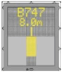
8. SAFEGATE DOCKING SYSTEM – IN SYSTEM AT PHUKET INTERNATIONAL AIRPORT
General warning
The DGS system has a built-in error detection program to inform the aircraft pilot of impending dangers during the docking procedure. If the pilot is unsure of the information, being shown on the DGS display unit, he must immediate stop the aircraft and obtain further information for clearance.
Item to check before entering the stand area
Warning : The pilot shall not enter the stand area, unless the docking system first is showing the vertical running arrows. The pilot must not proceed beyond the bridge, unless these arrows have been superseded by the closing rate bar.
Warning : The pilot shall not enter the stand area, unless the aircraft type displayed is equal to the approaching aircraft/ The Correctness of other information, such as ‘door 2’, shall also be checked.
The SBU message
The message STOP SBU means that docking has been interrupted and has to be resumed only by manual guidance. Do not try to resume docking without manual guidance.
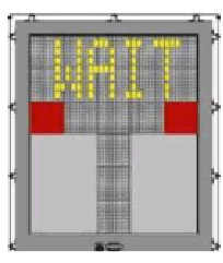 | START-OF-DOCKING The system is started by pressing one of the aircraft type buttons on the operator panel. When the button has been pressed, WAIT will be displayed. |
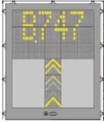 | CAPTURE The floating arrows indicate that the system is activated and in capture mode, searching for an approaching aircraft. It shall be checked that the correct aircraft type is displayed. The lead-in line shall be followed. The pilot must not proceed beyond the bridge, unless the arrows have been superseded by closing rate bar. |
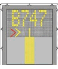 | TRACKING When the aircraft has been caught by the laser, the floating arrow is replaced by the yellow centre line indicator. A flashing red arrow indicates the direction to turn. The vertical yellow arrow shows position in relation to the centre line. This indicator gives correct position and azimuth guidance. |
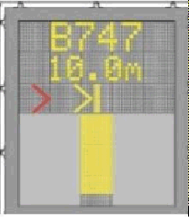 | CLOSING RATE. Display of digital countdown will start when the aircraft is 20 M from stop position.When the aircraft is less than 12 M from the stop position, the closing rate is indicated by turning off one row of the centre line symbol per 0.5 M, covered by the aircraft. Thus, when the last row is turned off, 0.5 M remains to stop. |
 | ALIGNED TO CENTRE. The aircraft is 8 M from the stop position. The absence of any direction arrow indicates an aircraft on the centre line. |
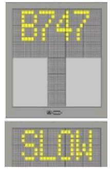
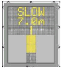 | SLOW DOWN. If the aircraft is approaching faster than the accepted speed, the system will show SLOW DOWN as a warning to the pilot. |
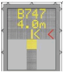 | AZIMUTH GUIDANCE. The aircraft is 4 M from the stop-position. The yellow arrow indicates an aircraft to the right of the centre line, and the red flashing arrow indicates the direction to turn. |
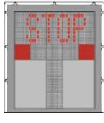 | STOP POSITION REACHED. When the correct stop-position is reached, the display will show STOP and red lights will be lit. |
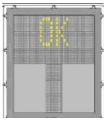 | DOCKING COMPLETE. When the aircraft has parked, OK will be displayed. |
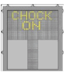 | CHOCKS ON. CHOCK ON will be displayed, when the ground staff has put the chocks in front of the nose wheel and pressed the “Chocks On” button on the operator panel. |
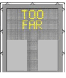 | OVERSHOOT. If the aircraft overshoot the stop-position, TOO FAR will be displayed. |
 | BAD WEATHER CONDITION. During heavy fog, rain or snow, the visibility for the docking system can be reduced. When the system is activated and in capture mode, the display will deactivate the floating arrows and show DOWN GRADE. This message will be superseded by the closing rate bar, as soon as the System detects the approaching aircraft. The pilot must not proceed beyond the bridge, unless the DOWN GRADE text has been superseded by the closing rate bar |
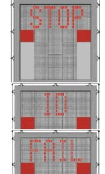 | AIRCRAFT VERIFICATION FAILURE. During entry into the stand, the aircraft geometry is being checked. If, for any reason, aircraft verification is not made 40 FT before the stop-position, the display will first show WAIT and make a second verification check. If this fails STOP and ID FAIL will be displayed. The text will be alternating on the upper two rows of the display. The pilot must not proceed beyond the bridge without manual guidance, unless the WAIT message has been superseded by the closing rate bar. |
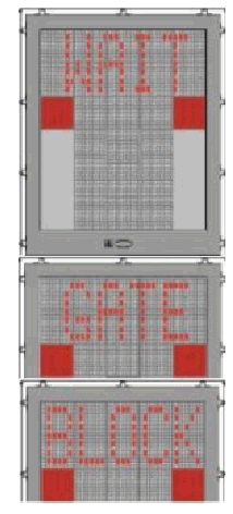 | GATE BLOCKED. If an object is found blocking the view from the DGS to the planned stop position for the aircraft, the docking procedure will be halted with a GATE BLOCK message. The docking procedure will resume as soon as the blocking object has been removed. The pilot must not proceed beyond the bridge without manual guidance, unless the WAIT message has been superseded by the closing rate bar. |
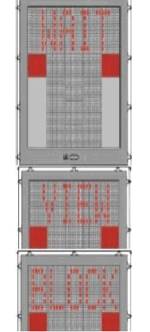 | VIEW BLOCKED. If the view towards the approaching aircraft is hindered for instance by dirt on the window, the DGS will report a view block condition. Once the system is able to see the aircraft through the dirt, the message will be replaced with a closing rate display. The pilot must not proceed beyond the bridge without manual guidance, unless the WAIT message has been superseded by the closing rate bar. |
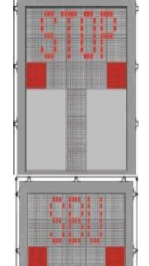 | SBU-STOP Any unrecoverable error during the docking procedure will generate an SBU condition. The display will show red stop bar and the text STOP SBU. A manual backup procedure must be used for docking guidance. |
 | EMERGENCY STOP When the emergency stop button is pressed, STOP is displayed. |
 | ERROR If a system error occurs, the message ERROR is display with an error code. The code is used for maintenance purposes and explained else where. |
 | SYSTEM BREAKDOWN In case of a severe system failure, the display will go black, except for a red stop indicator. A manual backup procedure must be used for docking guidance. |
 | POWER FAILURE In case of a power failure, the display will be completely black. A manual backup procedure must be used for docking guidance. |
9. General Information
The supplementary of general information has been established at Phuket International Airport as follows :-
Type of apron : Remote parking and contact gate parking
Aircraft can be parked for overnight parking and layover.
Nose-in parking system
Visual Docking Guidance System-VDGS is provided at stand 1-6 for apron B and stand 7-16 for apron A. If VDGS is out of service, a marshaller shall guide the aircraft to the parking position.
Visual Docking Guidance System-VDGS is not provided for MARS stand (12L,12R,14L,14R), a marshaller shall guide the aircraft to the parking position.
Refuel JET A-1 and AVGAS by trailer and hydrant system.
Type of apron : Remote parking
Visual Docking Guidance System-VDGS is not provided
Refuel JET A-1 and AVGAS by trailer.
Type of apron : Remote parking
Aircraft can be parked for overnight parking and layover.
Nose – in parking system
Visual Docking Guidance System-VDGS is provided at each stand (included MARS stands). If VDGS is out of service, a marshaller shall guide the aircraft to the parking position.
Refuel JET A-1 and AVGAS by trailer and hydrant system.
Taxilane T1 is the parallel to Taxilane T2. (Taxilane T1 located behind aircraft stand NO.31-40 and Taxilane T2 located behind aircraft stand NO.7-16)
The distance between centre lines of T1 and T2 is 80 M.
The distance between centre line of Taxilane T1 and aircraft tail limit line is 47.50 M.
The distance between centre line of Taxilane T2 and aircraft tail limit line is 47.40 M.
Taxilane T3, T4, T5, T6 and T7 connected with Taxilane T1 and T2 can accommodate aircraft code letter E and below
VTSP AD 2.21 NOISE ABATEMENT PROCEDURES
NIL
VTSP AD 2.22 FLIGHT PROCEDURES
1. REVISED IMPLEMENTATION OF THE CONTINUOUS DESCENT OPERATIONS (CDO) FOR ARRIVALS INTO PHUKET INTERNATIONAL AIRPORT
Note: 1.There is limited benefit if CDO clearance is received at altitude lower than 10,000 FT.
Note: 2.In case of CDO procedure being impractical due to an emergency, weather condition, traffic situation or any other reasons, an alternate instruction will be issued by ATC, or requested by pilot.
CDO procedure is applicable for FMS capable aircraft.
CDO procedure is in place for all aircraft on G458 inbound to Phuket International Airport via STAR SAVSA1D.
CDO is available 24 hours.
CDO procedure is available for RWY 27
When traffic permits, aircraft will operate at an optimum speed calculated by FMS, depending on aircraft type. The following speed guidance should be applicable in case of high traffic volume.
| Flight Status | Speed Range |
|---|---|
| Above 10 000 FT. | 250 – 320 IAS |
| Below 10 000 FT. | 220 – 250 IAS |
| Final Segment (up to 4 NM) | 160 – 180 IAS |
Aircraft Arriving on G458
Aircraft Arriving on G458, reaching SAVSA altitude not higher than 10,000 FT., then follow on SAVSA1D to BARON altitude not lower than 3,000 FT. then connect to IF for ILS or LLZ, RNAV (GNSS) or VOR Z RWY 27 approach procedure as published in AIP Thailand.
The pilot may request permission to fly directly to Intermediate Fix (IF); however, this would be an ATC’s jurisdiction whether the request can be approved, depending on traffic conditions. In this case, the pilot shall fly directly to (IF), and will be advised by ATC, after (IF) follow the ILS or LLZ, RNAV (GNSS) or VOR Z RWY 27 approach procedure as published in AIP Thailand.
“(aircraft call sign), (ATC unit), CDO AVAILABLE, DO YOU ACCEPT?”
“(ATC Unit), (aircraft call sign), REQUEST CDO (type of approach) APPROACH”
“(aircraft call sign), CDO (type of approach) APPROVED DESCEND TO (level or altitude), QNH (number) SAVSA1D ARRIVAL”
“(aircraft call sign), FLY HEADING (three digits); TURN LEFT (or RIGHT) HEADING (three digits) VECTORING FOR CDO, POSITION (number) MILES FROM TOUCHDOWN”
“(aircraft call sign), RESUME CDO DIRECT (point), DESCEND TO (level or altitude), QNH (number), CLEAR (type of approach) APPROACH RWY27”
“(aircraft call sign), CDO LEAVING (level)”
“(aircraft call sign), BELOW CDO PROFILE, ALTITUDE SHOULD BE (altitude) OR ABOVE”
VTSP AD 2.23 ADDITIONAL INFORMATION
NIL
VTSP AD 2.24 CHARTS RELATED TO AN AERODROME
|
Chart name |
Page |
|---|---|
|
Aerodrome Chart - ICAO | AD 2-VTSP-2-1 |
|
Aircraft Parking/Docking Chart - ICAO | AD 2-VTSP-2-3 |
|
Aircraft Parking/Docking Chart - ICAO (Verso) | AD 2-VTSP-2-4 |
|
Aerodrome Ground Movement Chart - ICAO | AD 2-VTSP-2-5 |
|
Aerodrome Obstacle Chart - ICAO - Type A - RWY 09/27 | AD 2-VTSP-3-1 |
|
Aerodrome Obstacle Chart - ICAO - Type B - RWY 09/27 | AD 2-VTSP-3-3 |
|
Standard Departure Chart - Instrument (SID) - ICAO - RWY 09/27 | AD 2-VTSP-6-1 |
|
Standard Departure Chart - Instrument (SID) - ICAO - RWY 09/27 (Tabular description 1) | AD 2-VTSP-6-2 |
|
Standard Departure Chart - Instrument (SID) - ICAO - RWY 09/27 (Tabular description 2) | AD 2-VTSP-6-3 |
|
Standard Departure Chart - Instrument (SID) - ICAO - RNAV RWY 09 - ANPUB1A EMRIT1A EPGOT1A IGEVI1A ONETI1A REBED1A SATVA1A SAVSA1A SUSID1A UBNEN1A UPSAB1A | AD 2-VTSP-6-5 |
|
Standard Departure Chart - Instrument (SID) - ICAO - RNAV RWY 09 - ANPUB1A EMRIT1A EPGOT1A IGEVI1A ONETI1A REBED1A SATVA1A SAVSA1A SUSID1A UBNEN1A UPSAB1A (Tabular description 1) | AD 2-VTSP-6-6 |
|
Standard Departure Chart - Instrument (SID) - ICAO - RNAV RWY 09 - ANPUB1A EMRIT1A EPGOT1A IGEVI1A ONETI1A REBED1A SATVA1A SAVSA1A SUSID1A UBNEN1A UPSAB1A (Tabular description 2) | AD 2-VTSP-6-7 |
|
Standard Departure Chart - Instrument (SID) - ICAO - RNAV RWY 09 - ANPUB1A EMRIT1A EPGOT1A IGEVI1A ONETI1A REBED1A SATVA1A SAVSA1A SUSID1A UBNEN1A UPSAB1A (Waypoint list table) | AD 2-VTSP-6-8 |
|
Standard Departure Chart - Instrument (SID) - ICAO - RNAV RWY 27 - ANPUB1B EMRIT1B EPGOT1B IGEVI1B ONETI1B REBED1B SATVA1B SAVSA1B SUSID1B UBNEN1B UPSAB1B | AD 2-VTSP-6-9 |
|
Standard Departure Chart - Instrument (SID) - ICAO - RNAV RWY 27 - ANPUB1B EMRIT1B EPGOT1B IGEVI1B ONETI1B REBED1B SATVA1B SAVSA1B SUSID1B UBNEN1B UPSAB1B (Tabular description 1) | AD 2-VTSP-6-10 |
|
Standard Departure Chart - Instrument (SID) - ICAO - RNAV RWY 27 - ANPUB1B EMRIT1B EPGOT1B IGEVI1B ONETI1B REBED1B SATVA1B SAVSA1B SUSID1B UBNEN1B UPSAB1B (Tabular description 2) | AD 2-VTSP-6-11 |
|
Standard Departure Chart - Instrument (SID) - ICAO - RNAV RWY 27 - ANPUB1B EMRIT1B EPGOT1B IGEVI1B ONETI1B REBED1B SATVA1B SAVSA1B SUSID1B UBNEN1B UPSAB1B (Waypoint list table) | AD 2-VTSP-6-12 |
|
Standard Arrival Chart - Instrument (STAR) - ICAO - RNAV RWY 09 - ANPUB1C EMRIT1C EPGOT1C IGEVI1C MONBU1C ONETI1C SATVA1C SAVSA1C SUSID1C UBNEN1C UPSAB1C URGAD1C | AD 2-VTSP-7-1 |
|
Standard Arrival Chart - Instrument (STAR) - ICAO - RNAV RWY 09 - ANPUB1C EMRIT1C EPGOT1C IGEVI1C MONBU1C ONETI1C SATVA1C SAVSA1C SUSID1C UBNEN1C UPSAB1C URGAD1C (Tabular description 1) | AD 2-VTSP-7-2 |
|
Standard Arrival Chart - Instrument (STAR) - ICAO - RNAV RWY 09 - ANPUB1C EMRIT1C EPGOT1C IGEVI1C MONBU1C ONETI1C SATVA1C SAVSA1C SUSID1C UBNEN1C UPSAB1C URGAD1C (Tabular description 2) | AD 2-VTSP-7-3 |
|
Standard Arrival Chart - Instrument (STAR) - ICAO - RNAV RWY 09 - ANPUB1C EMRIT1C EPGOT1C IGEVI1C MONBU1C ONETI1C SATVA1C SAVSA1C SUSID1C UBNEN1C UPSAB1C URGAD1C (Tabular description 3) | AD 2-VTSP-7-4 |
|
Standard Arrival Chart - Instrument (STAR) - ICAO - RNAV RWY 09 - ANPUB1C EMRIT1C EPGOT1C IGEVI1C MONBU1C ONETI1C SATVA1C SAVSA1C SUSID1C UBNEN1C UPSAB1C URGAD1C (Waypoint list table) | AD 2-VTSP-7-5 |
|
Standard Arrival Chart - Instrument (STAR) - ICAO - RNAV RWY 27 - ANPUB1D EMRIT1D EPGOT1D IGEVI1D MONBU1D ONETI1D SATVA1D SAVSA1D SUSID1D UBNEN1D UPSAB1D URGAD1D | AD 2-VTSP-7-7 |
|
Standard Arrival Chart - Instrument (STAR) - ICAO - RNAV RWY 27 - ANPUB1D EMRIT1D EPGOT1D IGEVI1D MONBU1D ONETI1D SATVA1D SAVSA1D SUSID1D UBNEN1D UPSAB1D URGAD1D (Tabular description 1) | AD 2-VTSP-7-8 |
|
Standard Arrival Chart - Instrument (STAR) - ICAO - RNAV RWY 27 - ANPUB1D EMRIT1D EPGOT1D IGEVI1D MONBU1D ONETI1D SATVA1D SAVSA1D SUSID1D UBNEN1D UPSAB1D URGAD1D (Tabular description 2) | AD 2-VTSP-7-9 |
|
Standard Arrival Chart - Instrument (STAR) - ICAO - RNAV RWY 27 - ANPUB1D EMRIT1D EPGOT1D IGEVI1D MONBU1D ONETI1D SATVA1D SAVSA1D SUSID1D UBNEN1D UPSAB1D URGAD1D (Tabular description 3) | AD 2-VTSP-7-10 |
|
Standard Arrival Chart - Instrument (STAR) - ICAO - RNAV RWY 27 - ANPUB1D EMRIT1D EPGOT1D IGEVI1D MONBU1D ONETI1D SATVA1D SAVSA1D SUSID1D UBNEN1D UPSAB1D URGAD1D (Waypoint list table) | AD 2-VTSP-7-11 |
|
Instrument Approach Chart - ICAO - VOR y RWY 09 | AD 2-VTSP-8-1 |
|
Instrument Approach Chart - ICAO - VOR y RWY 27 | AD 2-VTSP-8-3 |
|
Instrument Approach Chart - ICAO - VOR z RWY 09 | AD 2-VTSP-8-5 |
|
Instrument Approach Chart - ICAO - VOR z RWY 27 | AD 2-VTSP-8-7 |
|
Instrument Approach Chart - ICAO - ILS or LLZ RWY 27 | AD 2-VTSP-8-9 |
|
Instrument Approach Chart - ICAO - RNAV (GNSS) z RWY 09 | AD 2-VTSP-8-11 |
|
Instrument Approach Chart - ICAO - RNAV (GNSS) z RWY 09 (Tabular description) | AD 2-VTSP-8-12 |
|
Instrument Approach Chart - ICAO - RNAV (GNSS) z RWY 27 | AD 2-VTSP-8-13 |
|
Instrument Approach Chart - ICAO - RNAV (GNSS) z RWY 27 (Tabular description) | AD 2-VTSP-8-14 |
|
Instrument Approach Chart - ICAO - RNAV (RNP) y RWY 09 | AD 2-VTSP-8-15 |
|
Instrument Approach Chart - ICAO - RNAV (RNP) y RWY 09 (Tabular description) | AD 2-VTSP-8-16 |
|
Instrument Approach Chart - ICAO - RNAV (RNP) y RWY 09 (Waypoint list table) | AD 2-VTSP-8-18 |
|
Instrument Approach Chart - ICAO - RNAV (RNP) y RWY 27 | AD 2-VTSP-8-19 |
|
Instrument Approach Chart - ICAO - RNAV (RNP) y RWY 27 (Tabular description) | AD 2-VTSP-8-20 |
|
Instrument Approach Chart - ICAO - RNAV (RNP) y RWY 27 (Waypoint list table) | AD 2-VTSP-8-21 |