AD 2 AERODROMES
VTBD — Bangkok/ Don Mueang International Airport
VTBD AD 2.1 AERODROME LOCATION INDICATOR AND NAME
VTBD — Bangkok/ Don Mueang International Airport
VTBD AD 2.2 AERODROME GEOGRAPHICAL AND ADMINISTRATIVE DATA
| 1 |
ARP coordinates and site at AD |
135451.74N
1003620.49E
centre line of RWY 03L/21R, 1510 M from THR RWY 21R |
| 2 |
Direction and distance from (city) | 12 NM NE of Bangkok |
| 3 |
Elevation/Reference temperature | 2.65 M(9 FT) / 35°C |
| 4 | Geoid Undulation at AD ELEV PSN |
NIL |
| 5 |
MAG VAR/Annual change | 0°36'W(2016)/0°0'E |
| 6 |
AD Administration, address, telephone, |
Airports of Thailand Public Company Limited (AOT)
Tel: +662 535 1515 Tel: +662 535 1516 Fax: +662 535 1065 Fax: +662 535 1306 E-mail: dmk.dep@airportthai.co.th Website: www.airportthai.co.th AFS: VTBDYDYX |
| 7 |
Types of traffic permitted (IFR/VFR) | IFR/VFR |
| 8 |
Remarks | Operator: Airports of Thailand Public Company Limited (AOT) |
VTBD AD 2.3 OPERATIONAL HOURS
| 1 |
Aerodrome Operator | H24 |
| 2 |
Customs and immigration |
H24 |
| 3 |
Health and sanitation | H24 |
| 4 |
AIS Briefing Office | H24 |
| 5 |
ATS Reporting Office (ARO) | H24 |
| 6 |
MET Briefing Office | H24 |
| 7 |
ATS | H24 |
| 8 |
Fuelling | H24 |
| 9 |
Handling | H24 |
| 10 |
Security | H24 |
| 11 |
De-icing |
NIL |
| 12 |
Remarks |
NIL |
VTBD AD 2.4 HANDLING SERVICES AND FACILITIES
| 1 |
Cargo-handling facilities |
Available form
|
| 2 |
Fuel/oil types | Jet A1 and AVGAS |
| 3 |
Fuelling facilities/capacity |
Bangkok Aviation Fuel Service Public Co.,Ltd. (BAFS) Website: www.bafsthai.com Tel: +662 834 8900 Fax: +662 834 8999 Fuel Dispenser Truck: 21 Fuel Truck: 7, Capacity: 65,000 L |
| 4 |
De-icing facilities |
NIL |
| 5 |
Hangar space for visiting aircraft | Private Aircraft operated by Mjets Ltd. |
| 6 |
Repair facilities for visiting aircraft |
Private Aircraft operated by Mjets Ltd. |
| 7 |
Remarks |
The airport has provided ground handling agents as following number:
|
VTBD AD 2.5 PASSENGER FACILITIES
| 1 |
Hotels |
At the 4th floor (Terminal 2) Tel: +662 535 7555-8 Also near AD and in the city |
| 2 |
Restaurants | At the AD and in the city |
| 3 |
Transportation | Public Taxi, Airport Taxi, Limousine service, Airport Shuttle Bus, Limo Bus, Train, Bus and Car rental service. |
| 4 |
Medical facilities | First aid at Airport Clinic, H24 |
| 5 |
Bank and Post Office |
Bank: At Terminal 1 & 2 Post office: At the 3rd Floor (Terminal 1 & 2) Tel: +662 504 3070 (Terminal 1) Tel: +662 504 3181 (Terminal 2) Open : Daily 0130 - 1200 |
| 6 |
Tourist Office |
Office at the 1st Floor (Terminal 1) Arrival hall; Tel: +662 535 3433 |
| 7 |
Remarks |
For further information Tel: +662 535 1192 Tel: +662 535 2110 E-mail: psd_dmk@airportthai.co.th |
VTBD AD 2.6 RESCUE AND FIRE FIGHTING SERVICES
| 1 |
AD category for fire fighting | Category 9 |
| 2 |
Rescue equipment |
Adequately provided as recommended by ICAO |
| 3 |
Capability for removal of disabled aircraft | Available up to B747 |
| 4 |
Remarks |
For removal of disabled aircraft by contracted external resource please contact aerodrome coordinator: Airport Operations Department - Airside Services Division Tel: +662 535 1283 Tel: +662 535 1288 Rescue and Fire Fighting Department - Aircraft Fire Fighting Division Tel: +662 535 1118 |
VTBD AD 2.7 SEASONAL AVAILABILITY - CLEARING
| 1 |
Types of clearing equipment |
NIL |
| 2 |
Clearance priorities |
NIL |
| 3 |
Remarks | The aerodrome is available all seasons. |
VTBD AD 2.8 APRONS, TAXIWAYS AND CHECK LOCATIONS/POSITIONS DATA
| 1 | Apron surface and strength |
North Apron Surface: Concrete Strength: PCN 85/R/B/W/T Pier 2-3 Surface: Concrete Strength: PCN 69/R/B/W/T Pier 3-4 Surface: Concrete Strength: PCN 60/R/B/W/T Pier 4-5 Surface: Concrete Strength: PCN 48/R/B/W/T Pier 5-6 Surface: Concrete Strength: PCN 69/R/B/W/T Pier 6 Surface: Concrete Strength: PCN 68/R/B/W/T South Apron Surface: Concrete Strength: PCN 74/R/B/W/T |
| 2 | Taxiway width, surface and strength |
Width: 23 M - 50 M Surface: Concrete Strength: See Aerodrome Ground Movement Chart - ICAO for taxiway strength, surface and width. |
| 3 |
Altimeter checkpoint location and elevation |
Location: At Apron Elevation: 3.25 M/10 FT |
| 4 |
VOR checkpoints |
Location: - At holding position RWY 21R on TWY B (north) - RDL 023/2.2 NM - At holding position RWY 03L on TWY S (nearby TWY C) - RDL 012/0.6 NM Radio frequency: 117.7 MHZ |
| 5 |
INS checkpoints |
See Aerodrome Ground Movement Chart - ICAO (Verso) for coordinates of aircraft stand. |
| 6 |
Remarks |
Taxilane T between TWY V and TWY S can be used for Aircraft Code Letter A, B, C, D only |
VTBD AD 2.9 SURFACE MOVEMENT GUIDANCE AND CONTROL SYSTEM AND MARKINGS
| 1 |
Use of aircraft stand ID signs, TWY guide lines and visual docking/parking guidance system of aircraft stands |
Taxiing guidance signs at all intersections with TWY and RWY at all holding positions. Nose-wheel guide lines at aprons Solid nose-wheel guide lines at aircraft stands Guide lines at apron. Nose-in guidance at aircraft stands. |
| 2 |
RWY and TWY markings and LGT |
RWY: Designation, THR, TDZ, centre line, RWY Edge, RWY End, SWY as appropriate, marked and lighted. TWY: Holding position at all TWY/RWY Intersections, marked. Edge at all TWY, marked and lighted Centre line at all TWY, marked. Centre line at E, F, J, O, R, S, C (south), lighted Intermediate holding position light at TWY C between TWY O-R |
| 3 |
Stop bars |
Stop Bar Lights installed detail as follow:
|
| 4 |
Remarks | Aircraft marshalling and Towing service: The marshalling of scheduled and non-scheduled aircraft into the bays either manually and the pushing out of aircraft for departure shall be under the responsibility of the aircraft operator or its appointed ground handling agency. |
VTBD AD 2.10 AERODROME OBSTACLES
|
In approach/TKOF areas |
In circling areas and at AD |
Remarks | |||
|---|---|---|---|---|---|
| 1 | 2 | 3 | |||
|
RWY/Area affected |
Obstacle type Elevation Markings/LGT |
Coordinates |
Obstacle type Elevation Markings/LGT |
Coordinates | |
| a | b | c | a | b | |
|
NIL |
Radio mast HGT 70 M Marked, Lighted |
135307.86N
1003351.09E
|
NIL | ||
|
Radio mast HGT 61 M Marked, Lighted |
135452.97N
1003709.84E
|
NIL | |||
|
Building HGT 78 M Marked, Lighted |
135339.003N
1003341.633E
|
NIL | |||
|
Building HGT 87.10 M Lighted |
135212.77N
1003403.06E
|
NIL | |||
|
Building HGT 50 M Lighted |
135711.09N
1003715.04E
|
NIL | |||
VTBD AD 2.11 METEOROLOGICAL INFORMATION PROVIDED
| 1 |
Associated MET Office |
Aeronautical Meteorology Division, Thai Meteorological Department (TMD) |
| 2 |
Hours of service MET Office outside hours |
H24 NIL |
| 3 |
Office responsible for TAF preparation Periods of validity |
Aeronautical Meteorology Division 30 HR |
| 4 |
Type of landing forecast Interval of issuance |
TREND 30 Min |
| 5 |
Briefing/consultation provided |
Personal Consultation Tel: +662 535 1256 Fax: +662 535 1252 |
| 6 |
Flight documentation Language(s) used |
Charts, Tabular forms and Abbreviated Plain Language Texts. English |
| 7 |
Charts and other information available for |
S, U85, SWH, SWM, SWL, P85, P70, P50,P40, P30, P25, P20, P15, satellite and radar pictures |
| 8 |
Supplementary equipment available for |
Automated Weather Observation System (AWOS), Low Level Windshear Alert System (LLWAS), Weather Radar |
| 9 |
ATS units provided with information |
Don Mueang TWR |
| 10 | Additional information (limited of service, etc.) |
NIL |
VTBD AD 2.12 RUNWAY PHYSICAL CHARACTERISTICS
|
Designations RWY NR |
TRUE BRG |
Dimensions of RWY(M) | Strength (PCN) and surface of RWY and SWY |
THR coordinates RWY end coordinates THR geoid undulation | THR elevation and highest elevation of TDZ of precision APP RWY |
|---|---|---|---|---|---|
| 1 | 2 | 3 | 4 | 5 | 6 |
| 03L |
029° | 3700x60 |
PCN 115/F/B/W/T Asphalt |
135349.24N
1003545.38E
|
THR 2 M/7 FT |
| 21R |
209° | 3700x60 |
PCN 115/F/B/W/T Asphalt |
135534.87N
1003644.62E
|
THR 2 M/7 FT |
| 03R |
028° | 3500x45 |
PCN 126/F/D/W/T Asphalt |
135358.45N
1003605.50E
| THR 1.49 M/5 FT |
| 21L |
208° | 3500x45 |
PCN 126/F/D/W/T Asphalt |
135528.33N
1003655.97E
| THR 1.92 M/6.4 FT |
| Slope of RWY-SWY |
SWY dimensions (M) | CWY dimensions (M) | Strip dimensions (M) | RESA dimensions (M) | Location and description of arresting system | OFZ | Remarks | ||
|---|---|---|---|---|---|---|---|---|---|
| 7 | 8 | 9 | 10 | 11 | 12 | 13 | 14 | ||
|
-0.05% 0% -0.05% (350M 2 850M 500M) | 150x60 | 150x150 | 4120x260 |
120x90 |
NIL |
NIL |
NIL | ||
|
+0.056% 0% -0.05% (500M 2 850M 350M) | 150x60 | 150x150 | 4120x260 |
120x90 |
NIL |
NIL |
NIL | ||
|
+0.03% -0.036% (2 000M 1 500M) |
NIL | 150x150 | 3720x160 |
90x90 |
NIL |
NIL |
NIL | ||
|
+0.036% -0.03% (1 500M 2 000M) | 100x45 | 150x150 | 3720x160 |
90x90 |
NIL |
NIL |
NIL | ||
VTBD AD 2.13 DECLARED DISTANCES
|
RWY Designator |
TORA (M) |
TODA (M) |
ASDA (M) |
LDA (M) |
Remarks |
|---|---|---|---|---|---|
| 1 | 2 | 3 | 4 | 5 | 6 |
| 03L | 3700 | 3850 | 3850 | 3700 |
NIL |
| 21R | 3700 | 3850 | 3850 | 3700 |
NIL |
| 03R | 3500 | 3650 | 3500 | 3500 |
NIL |
| 21L | 3500 | 3650 | 3600 | 3150 |
NIL |
VTBD AD 2.14 APPROACH AND RUNWAY LIGHTING
|
RWY Designator |
APCH LGT type LEN INTST |
THRLGT colour WBAR |
VASIS (MEHT) PAPI |
TDZ, LGT LEN |
RWY Centre Line LGT Length, spacing, colour, INTST |
RWY edge LGT LEN, spacing, colour INTST |
RWY End LGT colour WBAR |
SWY LGT LEN (M) colour |
Remarks |
|---|---|---|---|---|---|---|---|---|---|
| 1 | 2 | 3 | 4 | 5 | 6 | 7 | 8 | 9 | 10 |
| 03L |
SALS 420 M LIH | Green |
PAPI Both 3° (71.46 FT) |
NIL |
3700M, 30 M White FM 2800 M-3400 M Red/White; FM 3400 M Red; LIH |
3700 M, 60 M White, FM 3100 M-3700 M Yellow; LIH |
Red |
150 M Red |
NIL |
| 21R |
CAT II 900 M LIH | Green |
PAPI Both 3° (65.06 FT) | 900 M |
3700 M, 30 M White FM 2800 M-3400 M Red/White; FM 3400 M Red; LIH |
3700 M, 60 M White, FM 3100 M-3700 M Yellow; LIH | Red |
150 M Red |
NIL |
| 03R |
SALS (5 BAR) 300 M LIH | Green |
PAPI Both 3° (63.81 FT) |
NIL |
NIL |
3500 M, 60 M White; FM 2900 M-3500 M Yellow; LIH | Red |
NIL |
NIL |
| 21L |
CAT I 900 M LIH | Green |
PAPI Both 3° (64.35 FT) |
NIL |
NIL |
3500 M, 60M Red; FM 350 M-2900 M White FM 2900 M Yellow; LIH | Red |
100 M Red |
NIL |
VTBD AD 2.15 OTHER LIGHTING, SECONDARY POWER SUPPLY
| 1 |
ABN/IBN location, characteristics and hours of operation |
ABN: At the top of TWR-S Building FLG WG EV 3 Sec IBN: NIL HN: IMC |
| 2 |
LDI location and LGT Anemometer location and LGT |
WDI : 1 WDI 700 M FM THR RWY 21R AND 500 M FM RWY 21R CL, BTN RWY 21R AND 21L illuminated : 1 WDI left side of THR RWY 21L, 158 M FM RWY CL illuminated |
| 3 |
TWY edge and centre line lighting |
Edge: All TWY Centre Line: TWY E, F, J, O, R, S, C(s) |
| 4 |
Secondary power supply/switch-over time |
-Secondary power supply to all lighting at RWY 21L/03R -Secondary power supply to all lighting at RWY 21R/03L |
| 5 |
Remarks |
Stop Bars at TWY B, D, S, C(s) Intermediate Holding Position Lights at TWY C between TWY O - R |
VTBD AD 2.16 HELICOPTER LANDING AREA
| 1 |
Coordinates TLOF or THR of FATO Geoid undulation |
NIL |
| 2 |
TLOF and/or FATO elevation M/FT |
NIL |
| 3 |
TLOF and FATO area dimensions, surface, strength, marking |
NIL |
| 4 |
True and MAG BRG of FATO |
NIL |
| 5 |
Declared distance available |
NIL |
| 6 |
APP and FATO lighting |
NIL |
| 7 |
Remarks |
NIL |
VTBD AD 2.17 ATS AIRSPACE
| 1 |
Designation and lateral limits | Don Mueang Aerodrome Traffic Zone (ATZ) a circle, radius 5 NM centred on VTBD ARP (135452N 1003620E) |
| 2 |
Vertical limits |
2000 FT / AGL |
| 3 |
Airspace classification | C |
| 4 |
ATS unit call sign Language(s) |
Don Mueang Tower English, Thai |
| 5 |
Transition altitude | 11000 FT MSL |
| 6 |
Remarks |
NIL |
VTBD AD 2.18 ATS COMMUNICATION FACILITIES
|
Service designation |
Call sign |
Frequency |
Hours of operation |
Remarks |
|---|---|---|---|---|
| 1 | 2 | 3 | 4 | 5 |
| APP |
Don Mueang Approach Bangkok Approach |
119.4 MHZ / 262.5 MHZ 128.95 MHZ / 262.5 MHZ 125.2 MHZ / 262.5 MHZ 124.35 MHZ / 262.5 MHZ 122.35 MHZ / 262.5 MHZ 119.1 MHZ / 262.5 MHZ 120.3 MHZ / 262.5 MHZ 125.8 MHZ2) 121.5 MHZ1) / 243.0MHZ1) | H24 |
1)Emergency frequency 2)Clearance delivery for aircraft departing to adjacent aerodromes and helicopters operating within BKK CTR 3)Arrival ATIS 4)Departure ATIS |
| CDC | Don Mueang Delivery |
127.7 MHZ | H24 | |
|
DAR | Don Mueang Arrival |
133.0 MHZ / 262.5 MHZ 121.5 MHZ1) / 243.0MHZ1) | H24 | |
| TWR | Don Mueang Tower | 118.1 MHZ / 236.6 MHZ | H24 | |
| SMC | Don Mueang Ground |
121.9 MHZ / 257.8 MHZ 122.5 MHZ / 257.8 MHZ | H24 | |
| ATIS | Don Mueang Intl Airport |
126.4 MHZ3)/ 344.6 MHZ3)/ 118.55 MHZ4) | H24 | D-ATIS synthesized voice broadcast |
VTBD AD 2.19 RADIO NAVIGATION AND LANDING AIDS
|
Type of aid, MAG VAR CAT of ILS/MLS (For VOR/ILS/MLS, give VAR) |
ID |
Frequency | Hours of operation |
Positions of transmitting antenna coordinates |
Elevation of DME transmitting antenna |
Remarks |
|---|---|---|---|---|---|---|
| 1 | 2 | 3 | 4 | 5 | 6 | 7 |
| DVOR/DME | BKK |
117.7 MHZ CH 124X | H24 |
135336.8N
1003546.3E
| 16.58 M |
DVOR/DME restriction due to obstacles surround DVOR/DME station, coverage check does not provide adequate signal 40 NM at required altitude in various areas as follows:
|
|
ILS CAT ll LOC-21R | IBKK | 109.3 MHZ | H24 |
135340.6N
1003540.6E
|
Instrument Landing System - Reference Datum Height (RDH) is 16.46 M (54 FT). A. Localizer - LOC 300 M (984 FT) from THR RWY 03L, along RWY centre line. Course width 3° B. Glide Path 3° - GP 333 M (1,093 FT) from THR RWY 21R, 120 M (394 FT) from RWY centre line. C.DME - Co-located with GP. | |
| GP/DME |
332.0 MHZ CH 30X | H24 |
135523.5N
1003642.8E
| |||
|
ILS CAT I LOC RWY21L | IDMG |
110.3 MHZ | H24 |
135351.83N
1003601.85E
|
Instrument Landing System
A. Localizer
B. Glide Path 3°
C. DME
| |
| GP/DME |
335.0 MHZ CH40X | H24 |
135521.25N
1003647.45E
| |||
|
ILS CAT I LOC RWY03L | IBKD |
109.7 MHZ CH34X | H24 |
135543.71N
1003649.60E
|
Instrument Landing System
A. Localizer
B. Glide Path 3°
C. DME
| |
| DME | H24 |
135544.88N
1003647.53E
| 3 FT | |||
| GP | 333.2 MHZ | H24 |
135356.48N
1003554.02E
|
VTBD AD 2.20 LOCAL AERODROME REGULATIONS
1. Technical Test Flights
A technical test flight after repair over Don Mueang International Airport can only be performed upon permission given by the Airport Authority at least 24 hours prior to each test flight.
2. Parking Area for General Aviation
The parking area for general aviation aircraft is also available.
3. Removal of Disabled Aircraft
4. Use of Runways 03R/21L – Don Mueang International Airport
1 500 FT for jet aircraft,
1 000 FT for conventional aircraft,
800 FT for light aircraft,
500 FT for helicopter.
5. Speed Control
Note: An instruction to “resume normal speed” does not delete speed restrictions that are applicable to published procedures of upcoming segments of flight, aircraft shall comply with the speed restrictions specified in 5.1, 5.2 and 5.3.
Note 1: En-route holding; MOCHI,BATOK, GOMES, RYN, JASSY, PASTA, TARDY, OSUKA, TL, NOBER.
Note 2: IAWP holding; ARONS, CAROS, DANNY, NAUTY, SILVA, CABIN, DAREN, GIPSY, NUMAN, TERRY.
6. Starting up Procedures
Additionally, in order to provide a more flexible ground traffic movement, all domestic departures shall no longer be required to push back within 5 minutes after clearance received.
7. Warning for Taxiing Aircraft
8. Closure of Runway
When the surface of the runway is unsafe (rough surface of dangerous obstruction on the manoeuvring area) or
At such other times and in conditions specified by NOTAM.
The pilot-in-command shall not take off and landing without a clearance from Don Mueang Tower
After Landing, The pilot-in-command shall vacate the runway as expeditiously as possible, in order to reduce runway occupancy time.
In the interest of maximizing the traffic flow during VMC conditions, Don Mueang Tower may authorize a departing aircraft to cross the Runway 21R to use RWY 21L for departure. This may cause reflection and/or diffraction of the ILS Glide Path signal. The arriving aircraft will be advised accordingly.
9. Low visibility procedures (LVP)
When vacating on TWY O taxi route is O-B or O-N and B
When vacating on TWY R taxi route is R-B
When vacating on TWY S taxi route is S-B
When vacating on TWY C(S) taxi route is C(S)-B
Pilots wishing to conduct an ILS guided take-off shall inform ATC on start-up in order to ensure that the protection of the localizer sensitive area is provided.
10. Pilot Procedure to Enhance Runway Capacity
To achieve the highest possible rate/hour for departure and arrival at Don Mueang International Airport, the runway occupancy times shall be reduced to a minimum. Therefore the follow procedure are introduced;
Pilots are reminded that rapid exit from the landing runway enables ATC to apply minimum spacing on Final Approach that will achieve maximum runway utilization as well as minimize the occurrence of go-arounds.
11. Aircraft Manoeuvring Procedures
In order to avoid jet blast damage to the terminal building and to aircraft, equipment and personnel on nearby stands, the following aircraft manoeuvring procedures are to be observed:
| Aircraft Stands | Aircraft Manoeuvring Procedures |
|---|---|
North Remote Apron Stands 1 2 3 4 5 6 7 8 9 10A 10B 10C 91 92 93 94 95 96 97 98 99 100A 100B 100C | The aircraft (on idle power) shall be pushed back to face either north or south till its nosewheel is at the intersection of the lead-in line and “taxilane A” centre line. Breakaway thrust will be applied when cleared to taxi. Remarks Stand 100B and stand 100C in case of push-back facing north, the aircraft shall then be towed forward until behind stand 100B. |
Terminal Apron Stands 12 | The aircraft (on idle power) shall be pushed back to face either north or south till its nosewheel is at the intersection of the lead-in line and “taxilane A” centre line. Breakaway thrust will be applied when cleared to taxi. |
| Stand 14 | The aircraft (on idle power) shall be pushed back to face north till its nosewheel is at the intersection of the lead-in line and “taxilane A” centre line, then tow forward until behind stand 14 or to face south till its nosewheel is at the intersection of the lead-in line and “taxilane A” centre line. Breakaway thrust will be applied when cleared to taxi. |
| Stand 15 | The aircraft (on idle power) shall be pushed back to face south till its nosewheel is at the intersection of the lead-in line and “taxilane A” centre line. Breakaway thrust will be applied when cleared to taxi. Alternative The aircraft (on idle power) shall be pushed back onto “taxilane B” to face either north or south behind the holding line. Breakaway thrust will be applied when cleared to taxi. |
| Stand 21 | The aircraft may start one engine to idle power. They will be pushed back onto “taxilane B” to face either north or south behind the holding line, where remaining engines may be started. Breakaway thrust will be applied when cleared to taxi. |
| Stands 23 25 | The aircraft may start one engine to idle power. They will be pushed back onto “taxilane B” to face either north or south behind the holding line, where remaining engines may be started. Breakaway thrust will be applied when cleared to taxi. Alternative The aircraft may start one engine to idle power. They will be pushed back onto “taxilane A” to face south till aircraft is behind the holding line abeam stand 15, other engines may be started to idle and breakaway thrust will be applied when cleared to taxi. |
| Stands 22 31 32 41 42 51 52 | The aircraft may start one engine to idle power. They will be pushed back onto “taxilane B” to face either north or south behind the holding line. Other engines may be started to idle power and breakaway thrust will be applied when cleared to taxi. |
| Stands 61 62 | The aircraft may start one engine to idle power. They will be pushed back onto “taxilane B” to face either north or south behind the holding line, Other engines may be started to idle power and breakaway thrust will be applied when cleared to taxi. |
| Stands 24 26 33 34 35 36 43 44 45 46 53 54 55 56 63 64 65 66 67 | The aircraft may start one engine to idle power. They will be pushed back onto “taxilane B” to face either north or south behind the holding line, Other engines may be started to idle power and breakaway thrust will be applied when cleared to taxi. Alternative The aircraft may start one engine to idle power. They will be pushed back onto aircraft stand taxilane to face east and then tow forward till its nosewheel is at “S” mark. Other engines may be started to idle power and breakaway thrust will be applied when cleared to taxi. |
| Stand 68 | The aircraft may start one engine to idle power. They will be pushed back onto “taxilane B” to face either north or south behind the holding line, where remaining engines may be started. Breakaway thrust will be applied when cleared to taxi. Alternative Aircraft up to A300 may start one engine to idle power. They will be pushed back onto aircraft stand taxilane to face east and then tow forward till its nosewheel is at “S” mark. Other engines may be started to idle power and breakaway thrust will be applied when cleared to taxi. |
South Remote Apron Stand 121 | The aircraft may start one engine to idle power. They will be pushed back onto “taxilane B” to face either north or south behind the holding line, where remaining engines may be started. Breakaway thrust will be applied when cleared to taxi. |
| Stand 122 | The aircraft may start one engine to idle power. They will be pushed back onto “taxilane B” to face either north till its nosewheel is behind the holding line abeam stand 73 or south till the aircraft is on “taxilane B” abeam stand 130. Other engines may be started and breakaway thrust will be applied when cleared to taxi. |
| Stand 123 125 127 129 | The aircraft may start one engine to idle power. They will be pushed back onto “taxilane B” to face either north or south behind the holding line, where remaining engines may be started. Breakaway thrust will be applied when cleared to taxi. Alternative The aircraft may start one engine to idle power. They will be pushed back onto aircraft stand taxilane to face east and then tow forward till its nosewheel is at “S” mark. Other engines may be started to idle power and breakaway thrust will be applied when cleared to taxi. |
| Stands 124 126 128 130 | The aircraft may start one engine to idle power. They will be pushed back onto “taxilane B” to face either north till the aircraft is behind the holding line abeam stand 73 or south till the aircraft is on “taxilane B” abeam stand 130. Other engines may be started to idle power and breakaway thrust will be applied when cleared to taxi. Alternative The aircraft may start one engine to idle power. They will be pushed back onto aircraft stand taxilane to face east and then tow forward till its nosewheel is at “S” mark. Other engines may be started to idle power and breakaway thrust will be applied when cleared to taxi. |
| Stands 73 74 75 76 77 78 79 80 81 82 83 84 85 86 87 88 101 102 103 104 105 106 107 109 110 112 113 114 115 | The aircraft (on idle power) shall be pushed back to face either north till its nosewheel is at the intersection of the lead-in line and “taxilane B” centre line or south till its body is aligned with “taxilane B” centre line. Breakaway thrust will be applied when cleared to taxi. |
| Stands 89 90 108 | The aircraft (on idle power) shall be pushed back to face north till its nosewheel is at the intersection of the lead-in line and “taxilane B” centre line. Then tow forward till its nosewheel is at the intersection of the lead-in line and “taxilane B” centre line of stand 89 or south till its nosewheel is at the intersection of the lead-in line and “taxilane B” centre line. Breakaway thrust will be applied when cleared to taxi. |
12. ALLOCATION OF AIRCRAFT PARKING BAYS
All aircraft parking bays are allocated by Ground/Apron controller with regard to aircraft type and the prevailing or anticipated traffic situation.
13. TAXIING PROCEDURES
Aircraft entering the aprons are to follow closely to the taxiway and apron centre line so as to avoid reducing safety distances between them and parking aircraft.
When start-up clearance is issued by ATC, then pushed out onto apron centre line and/or abeam centre line of taxilane B.
14. OPERATION OF MODE S TRANSPONDERS ON GROUND
15. PROVISION OF AERODROME AIR TRAFFIC SERVICES
16. HOT SPOT (HS) AREAS
VTBD AD 2.21 NOISE ABATEMENT PROCEDURES
In order to alleviate problem of noise within the vicinity of Bangkok international airport. The noise abatement procedures in accordance with ICAO DOC 8168-OPS/611 (PAN-OPS) shall be applied for all take-off and landing, details are as follows:
1. Departing aircraft
Pilots are to adopt either one of the two procedures listed below for all take-off
2. Arriving aircraft
Reverse thrust above idle shall not be used between 1800 and 2200 UTC. Except for safety reason.
VTBD AD 2.22 FLIGHT PROCEDURES
1. Provision of Radar Services
2. Approach Procedures with Radar Control
3. Standard Instrument Departures/Arrivals (RNAV SIDs/STARs)
Aircraft departing from or arriving at Don Mueang International Airport will normally be assigned the RNAV SIDs/STARs detailed in VTBD AD 2.24.
Note: Pilots of Non-RNAV equipped aircraft shall inform ATC and request for radar vectors.
4. Speed Control and Altitude Restrictions Promulgation in Bangkok TMA
In order to facilitate the air traffic flow procedure of departing and arriving aircraft within Bangkok TMA, speed control procedures and altitude restricted must be applied to optimize the spacing between aircraft and reduce the overall delay of traffic.
When a departing aircraft on a SID is cleared to climb to a level higher than the initially cleared level or the level(s) specified in the SID, the aircraft shall nevertheless follow the published vertical profile, unless such restrictions are explicitly cancelled by ATC.
5. TCAS RA Warning
Avoidance of unnecessary TCAS RA warning, aircraft shall strictly use rate of climb or rate of descent at 1 500 FPM or less within 2 000FT to the assigned altitude or flight level, then use rate of climb or rate of descend at 1 000 FPM or less within 1 000 FT to the assigned altitude or flight level when flight crew is made aware of another aircraft at or approaching an adjacent altitude or flight level, unless otherwise instructed by ATC.
6. Operational for Safety and More Effective Air Traffic Management in Bangkok TMA
7. Delay during Severe Weather
4 minutes or more between successive departures on the same SID or between aircraft intending to fly in the direction where severe weather is reported.
4 minutes or more between successive arrivals on the same STAR/at the same IAWP or between aircraft intending to fly in the direction where severe weather is reported.
8. VFR Flight in Bangkok Control Zone
Unless authorized, VFR flight will not be permitted to land / take-off at Don Mueang International Airport when weather conditions as reported to Don Mueang APP/TWR by an authorized ground observer are LESS than:
Ground Visibility 5 KM; or Ceiling 450 M (1500 FT) Authorization may be granted by ATC for special VFR flight, (see 8.4) to land / take-off at Don Mueang International Airport under conditions LESS than (8.1) above but NOT LESS than
Ground Visibility 1500 M
Authorization may be granted by ATC for VFR flight to land / take-off at Don Mueang International Airport under conditions reported to be AT or BETTER than (8.1) above; such flight will be treated as special VFR flight (see 8.4) for ATC purposes.
VFR flight within Bangkok CTR shall be conducted so that the aircraft maintain flight visibility and distance from cloud EQUAL TO or GREATER THAN those specified in ICAO Annex 2, Table 3-1.
Flight Visibility 5 KM below 3050 M (10 000 FT) AMSL and
8 KM at and above 3050 M (10 000 FT) AMSL
Distance from cloud 1500 M horizontally and 300 M (1000 FT) vertically
The details of VFR entry and exit procedures are given in ENR 2.2, Item 1. VFR ENTRY AND EXIT PROCEDURES IN BANGKOK CONTROL ZONE.
Aircraft will not be permitted to take off unless two-way radio communications can be maintained with the control tower.
Report position, distance, heading and altitude as well as departure point when approaching 50 NM from BKK VOR by blind transmission.
Observe the direction of traffic in pattern and enter downwind with the flow of traffic.
Conform to the altitude for the type of aircraft as listed in Note below.
Make a low approach between the runways at an altitude of 500 FT, and rock the wings of the aircraft.
Re-enter downwind leg and observe light signals.
Pilots may endeavour to communicate with ATC by telephone network. The telephone numbers are as follows:
Don Mueang Tower
Tel: +662 515 3282, +662 515 3288, +668 1710 7449
Suvarnabhumi Tower
Tel: +662 131 3610-3, +668 6399 9030
Bangkok Approach
Tel: +662 131 3621, +662 131 3622, +668 5150 2288, +668 5150 3300
Note: Traffic Patterns and Altitude:
Jet Aircraft 1500 FT
Conventional Aircraft 1000 FT
Light Aircraft 800 FT
Helicopter 500 FT
Traffic Pattern, Bangkok control zone and Don Mueang aerodrome traffic zone are shown below:
Illustration of Traffic Pattern
Illustration of Bangkok control zone and Don Mueang aerodrome traffic zone
9. TRAINING IN DANGER AREA
-
Jet / Conventional Aircraft departing from Don Mueang International Airport must contact Don Mueang Approach on frequency 119.4 MHZ
-
Before leaving VTD47 the pilot must report his position, distance and heading to Don Mueang Approach.
-
Test Flights: If the pilot desires to fly outside the area of VTD47, he must maintain two-way radio communications with, and follow instruction from Bangkok Approach/Don Mueang Approach.
Light Aircraft departing form Don Mueang International Airport must contact Don Mueang Approach, the controller will instruct the pilot over Bangbuathong at altitude not above 1000 feet before entering D72.
Before leaving VTD72 the pilot must report his position, distance and heading to Don Mueang Approach. The controller will instruct the pilot to report over Ladlumkaew at altitude not above 1000 FT, report Patum-thani, 5 NM West and then report entering downwind for landing RWY 21L/R or RWY 03R/L.
10. Fuel Dumping Procedure and In-flight Fuel Management Procedures
An aircraft in emergency or other urgent situations may need to dump fuel so as to reduce to maximum landing mass in order to affect a safe landing.
Illustration of Fuel dumping areas
Minimum fuel: The term used to describe a situation in which an aircraft’s fuel supply has reached a state where the flight is committed to land at a specific aerodrome and no additional delay can be accepted.
Mayday fuel: Describes the nature of the distress conditions when the calculated usable fuel predicted to be available upon landing at the nearest aerodrome where a safe landing can be made is less than the planned final reserve fuel.
Note 1: The declaration of “MINIMUM FUEL” informs ATC that all planned aerodrome options have been reduced to a specific aerodrome of intended landing and any changes to the existing clearance may result in landing with less than planned final reserve fuel. This is not an emergency situation but an indication that an emergency situation is possible should any additional delays occur.
Note 2: It should be noted that Pilots should not expect any form of priority handling as a result of a “MINIMUM FUEL” declaration. ATC will, however, advise the flight crew of any additional expected delays as well as coordinate when transferring control of the aircraft to ensure that other ATC units are aware of the flight’s fuel state.
Note 1: The planned final reserve fuel refers to the value calculated in Annex 6 - Operation of Aircraft, Chapter4, item 4.3.6.3 e) 1) or 2) and is the minimum amount of fuel required upon landing at any aerodrome.
Note 2: The words “MAYDAY FUEL” describe the nature of the distress conditions as required in Annex 10, Volume II, Chapter 5.3.2.1, b) 3).
Note 3: Guidance on procedures for in-flight fuel management is contained in the Fuel Planning Manual (Doc 9976).
The estimated delay, if pilots are en-route to, joining or are established in holding point such as IAWPs; or
The estimated track mileage, if pilots are being vectored to an instrument approach; or
Pilot transmission: (C/S), MINIMUM FUEL
Controller transmission: (C/S), ROGER [NO DELAY EXPECTED or EXPECT (delay information)]
Pilot transmission: (C/S) MAYDAY, MAYDAY, MAYDAY FUEL
Controller transmission: (C/S) ROGER MAYDAY
11. Aircraft Transponder Failure Procedures
Phraseologies
“C/S, CONFIRM TRANSPONDER ON”, or
“C/S, CHECK YOUR TRANSPONDER OPERATED NORMALLY”, or
“C/S, TRANSPONDER NOT RECEIVED, CHECK FUNCTIONALITY”
When it has been confirmed that aircraft transponder fails, ATC shall advice the pilot to repair it before departure. However, the surface radar blind spot, where the transponder might not be easily detected, should be taken into consideration.
Phraseologies
“C/S, ADVISE TRANSPONDER REPAIRED BEFORE DEPARTURE”, or
“C/S, ADVISE RETURN TO BAY FOR TRANSPONDER REPAIRING”
Phraseologies
“C/S, CONFIRM TRANSPONDER ON”, or
“C/S, CHECK YOUR TRANSPONDER OPERATED NORMALLY”, or
“C/S, TRANSPONDER NOT RECEIVED, CHECK FUNCTIONALITY”
When it has been confirmed that the aircraft transponder fails, ATC shall advice the pilot to return to his departure airport as well as relay all necessary information to Aerodrome Control Tower and all concerned units.
Phraseologies
“C/S, ADVISE RETURN TO LAND AT (DEPARTURE AERODROME) FOR TRANSPONDER REPAIRING, REQUEST YOUR INTENTION”,
“C/S, ADVISE RETURN TO BAY FOR TRANSPONDER REPAIRING”
In case pilot decide to proceed to first intended landing or nearest suitable aerodrome, primary radar separation shall be provided. However, the pilot shall be reminded that delays can be expected and some requests might not be granted e.g. route to be flown, cruising altitude/level.
12. Radio Communication Failure Procedure
Proceed according to the STAR route to the termination point AROKA for RWY 21L/21R or DM303DOTLI for RWY 03L/03R and descend in accordance with the published all speed and altitude restrictions of the relevant STAR procedure, thence:
For RWY 21L/21R: at AROKA and maintain altitude 3000 FT. The pilot shall make a right holding pattern as published and carry out the appropriate approach procedure.
For RWY 03L/03R: At
proceed to DM303 and maintain altitude 3000 FT. The pilot shall make a right holding pattern with inbound course of 090 and one-minute-leg, then descend to 2300 FT and carry out the appropriate approach procedure.DOTLI, carry out the appropriate approach procedure.
For RWY 21L/21R: maintain altitude 4 000 FT and proceed direct to BKK VOR then transition to IAF and carry out an appropriate approach procedure.
For RWY 03L/03R: maintain altitude 5 000 FT and proceed direct to DOTLI, carry out the appropriate approach procedure. Except ILS or LOC y RWY03L and VOR RWY03R: maintain altitude 5 000 FT and proceed direct to BKK VOR then transition to IAF and carry out an appropriate approach procedure.
Pilots may endeavour to communicate with ATC by telephone network.
The telephone numbers are as follows:
Don Mueang Tower Tel: +662 515 3282, +662 515 3288, +6681 710 7449
Suvarnabhumi Tower Tel: +662 131 3610-3, +6686 399 9030
Bangkok Approach Tel: +662 131 3621, +662131 2622, +6685 150 2288 and +6685 150 3300
VTBD AD 2.23 ADDITIONAL INFORMATION
Requirement for Airbus A380 and Boeing 747-8 operations at Don Mueang International Airport as an alternate airport.
The operations of Airbus A380 and Boeing 747-8 aircraft at Don Mueang International Airport as an alternate airport will be complied with the following regulations:
-
The Airbus A380 and Boeing 747-8 aircraft operation procedures prescribe specially for alternating airport at Don Mueang International Airport ONLY.
-
All airlines wishing to operate the Airbus A380 and Boeing 747-8 aircraft at Don Mueang International Airport as an alternate airport are required to comprehend and agree with the requirement of Airbus A380 and Boeing 747-8 operations at Don Mueang International Airport as an alternate airport and shall be inform the airport authority and the approval must be received before operations.
-
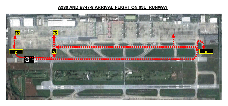
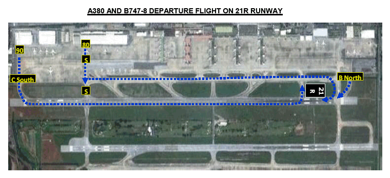
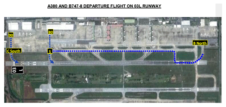
Runway 03L/21R has been approved for the designated primary arrivals and departures runway for Airbus A380 and Boeing 747-8 aircraft ONLY.
-
The primary parking position is assigned at the aircraft stand No.80 and the alternate parking positions are at aircraft stand No.90 and Taxiway B North.
-
The maneuvering area designation system is illustrated on VTBD aerodrome – Airbus A380 and Boeing 747-8 ground movement chart.
-
Upon operating to and from the aircraft stand, the Airbus A380 and Boeing 747-8 aircraft are required to strictly follow the “Follow me” guidance and be ensure that aircraft clearances and wingtips are escorted by wingman.
-
Taxi and ground movement procedures are prescribed as follow:
-
Taxi aid camera system is used for aircraft taxiing and ground operation. (If applicable)
-
The Airbus A380 and Boeing 747-8 aircraft are required to taxi within the speed limit.
-
While the Airbus A380 or Boeing 747-8 aircraft is operating on Taxiway C, the aircraft operating on Taxiway B shall be restricted up to the aircraft code C (aircraft with a maximum wingspan of 36 M).
-
While other aircraft is taking off or landing on the runway 03L/21R, the Airbus A380 or Boeing 747-8 aircraft entering the runway 03L/21R is required to hold on Taxiway C.
-
The aircraft gross weight of any Airbus A380 or Boeing 747-8 operating at Don Mueang International Airport must not be over 420 T
-
-
All ground service equipments needed by the Airbus A380 or Boeing 747-8 aircraft at Don Mueang International Airport must be provided by an airline operating the Airbus A380 or Boeing 747-8 aircraft or provided by any ground service equipment company at Don Mueang International Airport.
-
In case of the Airbus A380 or Boeing 747-8 aircraft accident or incident on the Airport, an aircraft owner operating the Airbus A380 or Boeing 747-8 shall be responsibility of disable aircraft removal as soon as possible.
-
Turn right on taxiway S to aircraft stand number 80 or
-
Turn right on taxiway C South to aircraft stand number 90
-
Turn right to taxiway S then turn right and taxi on taxiway C facing to north till taxiway D then turn left to taxiway D and turn right to park on taxiway B north
-
Turn left on taxiway D and turn right to park on taxiway B north or
-
Turn left on taxiway E or taxiway D to taxiway D to taxiway C then taxi to south and
-
Turn right on taxiway S to aircraft stand number 80 or
-
Turn left on taxiway S to runway and taxi to taxiway C south to aircraft stand number 90
AIRCRAFT STAND NO 80:
-
The aircraft shall be pushed back onto taxilane B (to face either north or south) and tow forward till the aircraft is on taxiway S.
-
Turn left to taxiway C and taxing toward north after that turn right onto taxiway D and prepare to take-off on runway.
AIRCRAFT STAND NO 90:
-
The aircraft shall be pushed back onto taxilane B (to face south only) and tow the aircraft on to taxilane B to stop beside aircraft stand number 108 and release the tow bar.
-
The aircraft shall be taxied on taxiway C south and turn left to runway.
-
The aircraft shall be taxied on runway forward north.
-
Turn left on taxiway E and turn right on taxiway C after that turn on taxiway D to the runway.
B NORTH
-
The aircraft shall be taxied to runway 21R.
AIRCRAFT STAND NO 80:
-
The aircraft shall be pushed back onto taxilane B (to face either north or south) and tow forward till the aircraft is on taxiway S.
-
Turn left to runway (distance for take-off ~2,900 M.)
AIRCRAFT STAND NO 90:
-
The aircraft shall be pushed back onto taxilane B (to face south only) and tow the aircraft on to taxiway C south on runway holding position.
-
Turn left on runway 03L.
B NORTH
-
The aircraft shall be taxied to runway 21R.
-
Turn right on taxiway E and turn left on taxiway C, taxing toward south.
-
Turn left on taxiway S to runway 21R (distance for take-off ~2,900 M) (In case of low visibility, not allow to use runway 03L)
-
VTBD AD 2.24 CHARTS RELATED TO AN AERODROME
|
Chart name |
Page |
|---|---|
|
Aerodrome Chart - ICAO | AD 2-VTBD-2-1 |
|
Aircraft Parking/Docking Chart - ICAO | AD 2-VTBD-2-3 |
|
Aircraft Parking/Docking Chart - ICAO (Verso) | AD 2-VTBD-2-4 |
|
Aerodrome Ground Movement Chart - ICAO | AD 2-VTBD-2-5 |
|
Precision Approach Terrain Chart - ICAO - RWY 21R | AD 2-VTBD-3-1 |
|
Aerodrome Obstacle Chart - ICAO Type A - RWY21R/03L | AD 2-VTBD-3-3 |
|
Aerodrome Obstacle Chart - ICAO Type A - RWY21L/03R | AD 2-VTBD-3-5 |
|
Standard Departure Chart - Instrument (SID) - ICAO - RNAV RWY 21L - ALBOS3C BONVO3C NOBER3C NUNLI3C PASTO3C ROBKA3C SEMBO3C TANGO3C TARED3C TL3C UPKUP3C | AD 2-VTBD-6-1 |
|
Standard Departure Chart - Instrument (SID) - ICAO - RNAV RWY 21L - ALBOS3C BONVO3C NOBER3C NUNLI3C PASTO3C ROBKA3C SEMBO3C TANGO3C TARED3C TL3C UPKUP3C (Radio communication failure table) | AD 2-VTBD-6-2 |
|
Standard Departure Chart - Instrument (SID) - ICAO - RNAV RWY 21L - ALBOS3C BONVO3C NOBER3C NUNLI3C PASTO3C ROBKA3C SEMBO3C TANGO3C TARED3C TL3C UPKUP3C (Tabular description 1) | AD 2-VTBD-6-3 |
|
Standard Departure Chart - Instrument (SID) - ICAO - RNAV RWY 21L - ALBOS3C BONVO3C NOBER3C NUNLI3C PASTO3C ROBKA3C SEMBO3C TANGO3C TARED3C TL3C UPKUP3C (Tabular description 2) | AD 2-VTBD-6-4 |
|
Standard Departure Chart - Instrument (SID) - ICAO - RNAV RWY 21L - ALBOS3C BONVO3C NOBER3C NUNLI3C PASTO3C ROBKA3C SEMBO3C TANGO3C TARED3C TL3C UPKUP3C (Tabular description 3) | AD 2-VTBD-6-5 |
|
Standard Departure Chart - Instrument (SID) - ICAO - RNAV RWY 21L - ALBOS3C BONVO3C NOBER3C NUNLI3C PASTO3C ROBKA3C SEMBO3C TANGO3C TARED3C TL3C UPKUP3C (Waypoint list table) | AD 2-VTBD-6-6 |
|
Standard Departure Chart - Instrument (SID) - ICAO - RNAV RWY 21L - DOSBU3C GORSI3C HHN3C KASNI3C KIGOB3C REGOS3C RYN3C SABIS3C UKERA3C | AD 2-VTBD-6-7 |
|
Standard Departure Chart - Instrument (SID) - ICAO - RNAV RWY 21L - DOSBU3C GORSI3C HHN3C KASNI3C KIGOB3C REGOS3C RYN3C SABIS3C UKERA3C (Radio communication failure table) | AD 2-VTBD-6-8 |
|
Standard Departure Chart - Instrument (SID) - ICAO - RNAV RWY 21L - DOSBU3C GORSI3C HHN3C KASNI3C KIGOB3C REGOS3C RYN3C SABIS3C UKERA3C (Tabular description 1) | AD 2-VTBD-6-9 |
|
Standard Departure Chart - Instrument (SID) - ICAO - RNAV RWY 21L - DOSBU3C GORSI3C HHN3C KASNI3C KIGOB3C REGOS3C RYN3C SABIS3C UKERA3C (Tabular description 2) | AD 2-VTBD-6-10 |
|
Standard Departure Chart - Instrument (SID) - ICAO - RNAV RWY 21L - DOSBU3C GORSI3C HHN3C KASNI3C KIGOB3C REGOS3C RYN3C SABIS3C UKERA3C (Tabular description 3) | AD 2-VTBD-6-11 |
|
Standard Departure Chart - Instrument (SID) - ICAO - RNAV RWY 21L - DOSBU3C GORSI3C HHN3C KASNI3C KIGOB3C REGOS3C RYN3C SABIS3C UKERA3C (Waypoint list table) | AD 2-VTBD-6-12 |
|
Standard Departure Chart - Instrument (SID) - ICAO - RNAV RWY 21R - ALBOS3A BONVO3A NOBER3A NUNLI3A PASTO3A ROBKA3A SEMBO3A TANGO3A TARED3A TL3A UPKUP3A | AD 2-VTBD-6-13 |
|
Standard Departure Chart - Instrument (SID) - ICAO - RNAV RWY 21R - ALBOS3A BONVO3A NOBER3A NUNLI3A PASTO3A ROBKA3A SEMBO3A TANGO3A TARED3A TL3A UPKUP3A (Radio communication failure table) | AD 2-VTBD-6-14 |
|
Standard Departure Chart - Instrument (SID) - ICAO - RNAV RWY 21R - ALBOS3A BONVO3A NOBER3A NUNLI3A PASTO3A ROBKA3A SEMBO3A TANGO3A TARED3A TL3A UPKUP3A (Tabular description 1) | AD 2-VTBD-6-15 |
|
Standard Departure Chart - Instrument (SID) - ICAO - RNAV RWY 21R - ALBOS3A BONVO3A NOBER3A NUNLI3A PASTO3A ROBKA3A SEMBO3A TANGO3A TARED3A TL3A UPKUP3A (Tabular description 2) | AD 2-VTBD-6-16 |
|
Standard Departure Chart - Instrument (SID) - ICAO - RNAV RWY 21R - ALBOS3A BONVO3A NOBER3A NUNLI3A PASTO3A ROBKA3A SEMBO3A TANGO3A TARED3A TL3A UPKUP3A (Tabular description 3) | AD 2-VTBD-6-17 |
|
Standard Departure Chart - Instrument (SID) - ICAO - RNAV RWY 21R - ALBOS3A BONVO3A NOBER3A NUNLI3A PASTO3A ROBKA3A SEMBO3A TANGO3A TARED3A TL3A UPKUP3A (Waypoint list table) | AD 2-VTBD-6-18 |
|
Standard Departure Chart - Instrument (SID) - ICAO - RNAV RWY 21R - DOSBU3A GORSI3A HHN3A KASNI3A KIGOB3A REGOS3A RYN3A SABIS3A UKERA3A | AD 2-VTBD-6-19 |
|
Standard Departure Chart - Instrument (SID) - ICAO - RNAV RWY 21R - DOSBU3A GORSI3A HHN3A KASNI3A KIGOB3A REGOS3A RYN3A SABIS3A UKERA3A (Radio communication failure table) | AD 2-VTBD-6-20 |
|
Standard Departure Chart - Instrument (SID) - ICAO - RNAV RWY 21R - DOSBU3A GORSI3A HHN3A KASNI3A KIGOB3A REGOS3A RYN3A SABIS3A UKERA3A (Tabular description 1) | AD 2-VTBD-6-21 |
|
Standard Departure Chart - Instrument (SID) - ICAO - RNAV RWY 21R - DOSBU3A GORSI3A HHN3A KASNI3A KIGOB3A REGOS3A RYN3A SABIS3A UKERA3A (Tabular description 2) | AD 2-VTBD-6-22 |
|
Standard Departure Chart - Instrument (SID) - ICAO - RNAV RWY 21R - DOSBU3A GORSI3A HHN3A KASNI3A KIGOB3A REGOS3A RYN3A SABIS3A UKERA3A (Tabular description 3) | AD 2-VTBD-6-23 |
|
Standard Departure Chart - Instrument (SID) - ICAO - RNAV RWY 21R - DOSBU3A GORSI3A HHN3A KASNI3A KIGOB3A REGOS3A RYN3A SABIS3A UKERA3A (Waypoint list table) | AD 2-VTBD-6-24 |
|
Standard Departure Chart - Instrument (SID) - ICAO - RNAV RWY 03L - ALBOS1B NOBER1B NUNLI1B ROBKA1B SEMBO1B TANGO1B TARED1B TL1B UPKUP1B | AD 2-VTBD-6-25 |
|
Standard Departure Chart - Instrument (SID) - ICAO - RNAV RWY 03L - ALBOS1B NOBER1B NUNLI1B ROBKA1B SEMBO1B TANGO1B TARED1B TL1B UPKUP1B (Radio communication failure table) | AD 2-VTBD-6-26 |
|
Standard Departure Chart - Instrument (SID) - ICAO - RNAV RWY 03L - ALBOS1B NOBER1B NUNLI1B ROBKA1B SEMBO1B TANGO1B TARED1B TL1B UPKUP1B (Tabular description 1) | AD 2-VTBD-6-27 |
|
Standard Departure Chart - Instrument (SID) - ICAO - RNAV RWY 03L - ALBOS1B NOBER1B NUNLI1B ROBKA1B SEMBO1B TANGO1B TARED1B TL1B UPKUP1B (Tabular description 2) | AD 2-VTBD-6-28 |
|
Standard Departure Chart - Instrument (SID) - ICAO - RNAV RWY 03L - ALBOS1B NOBER1B NUNLI1B ROBKA1B SEMBO1B TANGO1B TARED1B TL1B UPKUP1B (Tabular description 3) | AD 2-VTBD-6-29 |
|
Standard Departure Chart - Instrument (SID) - ICAO - RNAV RWY 03L - ALBOS1B NOBER1B NUNLI1B ROBKA1B SEMBO1B TANGO1B TARED1B TL1B UPKUP1B (Waypoint list table) | AD 2-VTBD-6-30 |
|
Standard Departure Chart - Instrument (SID) - ICAO - RNAV RWY 03L - BONVO1B DOSBU1B GORSI1B HHN1B KASNI1B KIGOB1B PASTO1B REGOS1B RYN1B SABIS2B UKERA1B | AD 2-VTBD-6-31 |
|
Standard Departure Chart - Instrument (SID) - ICAO - RNAV RWY 03L - BONVO1B DOSBU1B GORSI1B HHN1B KASNI1B KIGOB1B PASTO1B REGOS1B RYN1B SABIS2B UKERA1B (Radio communication failure table) | AD 2-VTBD-6-32 |
|
Standard Departure Chart - Instrument (SID) - ICAO - RNAV RWY 03L - BONVO1B DOSBU1B GORSI1B HHN1B KASNI1B KIGOB1B PASTO1B REGOS1B RYN1B SABIS2B UKERA1B (Tabular description 1) | AD 2-VTBD-6-33 |
|
Standard Departure Chart - Instrument (SID) - ICAO - RNAV RWY 03L - BONVO1B DOSBU1B GORSI1B HHN1B KASNI1B KIGOB1B PASTO1B REGOS1B RYN1B SABIS2B UKERA1B (Tabular description 2) | AD 2-VTBD-6-34 |
|
Standard Departure Chart - Instrument (SID) - ICAO - RNAV RWY 03L - BONVO1B DOSBU1B GORSI1B HHN1B KASNI1B KIGOB1B PASTO1B REGOS1B RYN1B SABIS2B UKERA1B (Tabular description 3) | AD 2-VTBD-6-35 |
|
Standard Departure Chart - Instrument (SID) - ICAO - RNAV RWY 03L - BONVO1B DOSBU1B GORSI1B HHN1B KASNI1B KIGOB1B PASTO1B REGOS1B RYN1B SABIS2B UKERA1B (Tabular description 4) | AD 2-VTBD-6-36 |
|
Standard Departure Chart - Instrument (SID) - ICAO - RNAV RWY 03L - BONVO1B DOSBU1B GORSI1B HHN1B KASNI1B KIGOB1B PASTO1B REGOS1B RYN1B SABIS2B UKERA1B (Waypoint list table) | AD 2-VTBD-6-37 |
|
Standard Departure Chart - Instrument (SID) - ICAO - RNAV RWY 03R - ALBOS1D NOBER1D NUNLI1D ROBKA1D SEMBO1D TANGO1D TARED1D TL1D UPKUP1D | AD 2-VTBD-6-39 |
|
Standard Departure Chart - Instrument (SID) - ICAO - RNAV RWY 03R - ALBOS1D NOBER1D NUNLI1D ROBKA1D SEMBO1D TANGO1D TARED1D TL1D UPKUP1D (Radio communication failure table) | AD 2-VTBD-6-40 |
|
Standard Departure Chart - Instrument (SID) - ICAO - RNAV RWY 03R - ALBOS1D NOBER1D NUNLI1D ROBKA1D SEMBO1D TANGO1D TARED1D TL1D UPKUP1D (Tabular description 1) | AD 2-VTBD-6-41 |
|
Standard Departure Chart - Instrument (SID) - ICAO - RNAV RWY 03R - ALBOS1D NOBER1D NUNLI1D ROBKA1D SEMBO1D TANGO1D TARED1D TL1D UPKUP1D (Tabular description 2) | AD 2-VTBD-6-42 |
|
Standard Departure Chart - Instrument (SID) - ICAO - RNAV RWY 03R - ALBOS1D NOBER1D NUNLI1D ROBKA1D SEMBO1D TANGO1D TARED1D TL1D UPKUP1D (Tabular description 3) | AD 2-VTBD-6-43 |
|
Standard Departure Chart - Instrument (SID) - ICAO - RNAV RWY 03R - ALBOS1D NOBER1D NUNLI1D ROBKA1D SEMBO1D TANGO1D TARED1D TL1D UPKUP1D (Waypoint list table) | AD 2-VTBD-6-44 |
|
Standard Departure Chart - Instrument (SID) - ICAO - RNAV RWY 03R - BONVO1D DOSBU1D GORSI1D HHN1D KASNI1D KIGOB1D PASTO1D REGOS1D RYN1D SABIS2D UKERA1D | AD 2-VTBD-6-45 |
|
Standard Departure Chart - Instrument (SID) - ICAO - RNAV RWY 03R - BONVO1D DOSBU1D GORSI1D HHN1D KASNI1D KIGOB1D PASTO1D REGOS1D RYN1D SABIS2D UKERA1D (Radio communication failure table) | AD 2-VTBD-6-46 |
|
Standard Departure Chart - Instrument (SID) - ICAO - RNAV RWY 03R - BONVO1D DOSBU1D GORSI1D HHN1D KASNI1D KIGOB1D PASTO1D REGOS1D RYN1D SABIS2D UKERA1D (Tabular description 1) | AD 2-VTBD-6-47 |
|
Standard Departure Chart - Instrument (SID) - ICAO - RNAV RWY 03R - BONVO1D DOSBU1D GORSI1D HHN1D KASNI1D KIGOB1D PASTO1D REGOS1D RYN1D SABIS2D UKERA1D (Tabular description 2) | AD 2-VTBD-6-48 |
|
Standard Departure Chart - Instrument (SID) - ICAO - RNAV RWY 03R - BONVO1D DOSBU1D GORSI1D HHN1D KASNI1D KIGOB1D PASTO1D REGOS1D RYN1D SABIS2D UKERA1D (Tabular description 3) | AD 2-VTBD-6-49 |
|
Standard Departure Chart - Instrument (SID) - ICAO - RNAV RWY 03R - BONVO1D DOSBU1D GORSI1D HHN1D KASNI1D KIGOB1D PASTO1D REGOS1D RYN1D SABIS2D UKERA1D (Tabular description 4) | AD 2-VTBD-6-50 |
|
Standard Departure Chart - Instrument (SID) - ICAO - RNAV RWY 03R - BONVO1D DOSBU1D GORSI1D HHN1D KASNI1D KIGOB1D PASTO1D REGOS1D RYN1D SABIS2D UKERA1D (Waypoint list table) | AD 2-VTBD-6-51 |
|
Standard Arrival Chart - Instrument (STAR) - ICAO - RNAV RWY 21L/21R - ENDUU3A NAKON3A SABAI3A SEHNA3A WEHHA3A | AD 2-VTBD-7-1 |
|
Standard Arrival Chart - Instrument (STAR) - ICAO - RNAV RWY 21L/21R - ENDUU3A NAKON3A SABAI3A SEHNA3A WEHHA3A (Radio communication failure table) | AD 2-VTBD-7-2 |
|
Standard Arrival Chart - Instrument (STAR) - ICAO - RNAV RWY 21L/21R - ENDUU3A NAKON3A SABAI3A SEHNA3A WEHHA3A (Tabular description 1) | AD 2-VTBD-7-3 |
|
Standard Arrival Chart - Instrument (STAR) - ICAO - RNAV RWY 21L/21R - ENDUU3A NAKON3A SABAI3A SEHNA3A WEHHA3A (Tabular description 2) | AD 2-VTBD-7-4 |
|
Standard Arrival Chart - Instrument (STAR) - ICAO - RNAV RWY 21L/21R - ENDUU3A NAKON3A SABAI3A SEHNA3A WEHHA3A (Tabular description 3) | AD 2-VTBD-7-5 |
|
Standard Arrival Chart - Instrument (STAR) - ICAO - RNAV RWY 21L/21R - ENDUU3A NAKON3A SABAI3A SEHNA3A WEHHA3A (Tabular description 4) | AD 2-VTBD-7-6 |
|
Standard Arrival Chart - Instrument (STAR) - ICAO - RNAV RWY 21L/21R - ENDUU3A NAKON3A SABAI3A SEHNA3A WEHHA3A (Tabular description 5) | AD 2-VTBD-7-7 |
|
Standard Arrival Chart - Instrument (STAR) - ICAO - RNAV RWY 21L/21R - ENDUU3A NAKON3A SABAI3A SEHNA3A WEHHA3A (Waypoint list table) | AD 2-VTBD-7-8 |
|
Standard Arrival Chart - Instrument (STAR) - ICAO - RNAV RWY 03L/03R - ENDUU1B NAKON1B SABAI1B SEHNA1B WEHHA1B | AD 2-VTBD-7-9 |
|
Standard Arrival Chart - Instrument (STAR) - ICAO - RNAV RWY 03L/03R - ENDUU1B NAKON1B SABAI1B SEHNA1B WEHHA1B (Radio communication failure table) | AD 2-VTBD-7-10 |
|
Standard Arrival Chart - Instrument (STAR) - ICAO - RNAV RWY 03L/03R - ENDUU1B NAKON1B SABAI1B SEHNA1B WEHHA1B (Tabular description 1) | AD 2-VTBD-7-11 |
|
Standard Arrival Chart - Instrument (STAR) - ICAO - RNAV RWY 03L/03R - ENDUU1B NAKON1B SABAI1B SEHNA1B WEHHA1B (Tabular description 2) | AD 2-VTBD-7-12 |
|
Standard Arrival Chart - Instrument (STAR) - ICAO - RNAV RWY 03L/03R - ENDUU1B NAKON1B SABAI1B SEHNA1B WEHHA1B (Tabular description 3) | AD 2-VTBD-7-13 |
|
Standard Arrival Chart - Instrument (STAR) - ICAO - RNAV RWY 03L/03R - ENDUU1B NAKON1B SABAI1B SEHNA1B WEHHA1B (Tabular description 4) | AD 2-VTBD-7-14 |
|
Standard Arrival Chart - Instrument (STAR) - ICAO - RNAV RWY 03L/03R - ENDUU1B NAKON1B SABAI1B SEHNA1B WEHHA1B (Tabular description 5) | AD 2-VTBD-7-15 |
|
Standard Arrival Chart - Instrument (STAR) - ICAO - RNAV RWY 03L/03R - ENDUU1B NAKON1B SABAI1B SEHNA1B WEHHA1B (Waypoint list table) | AD 2-VTBD-7-16 |
|
Instrument Approach Chart - ICAO - VOR RWY 21L | AD 2-VTBD-8-1 |
|
Instrument Approach Chart - ICAO - VOR RWY 21R | AD 2-VTBD-8-3 |
|
Instrument Approach Chart - ICAO - VOR RWY 03R | AD 2-VTBD-8-5 |
|
Instrument Approach Chart - ICAO - ILS or LOC y RWY 03L | AD 2-VTBD-8-7 |
|
Instrument Approach Chart - ICAO - ILS or LOC y RWY 21L | AD 2-VTBD-8-9 |
|
Instrument Approach Chart - ICAO - ILS or LOC y RWY 21L (Fix and point list table) | AD 2-VTBD-8-10 |
|
Instrument Approach Chart - ICAO - ILS or LOC y RWY 21R CAT II | AD 2-VTBD-8-11 |
|
Instrument Approach Chart - ICAO - ILS or LOC z RWY 21L | AD 2-VTBD-8-13 |
|
Instrument Approach Chart - ICAO - ILS or LOC z RWY 21L (Tabular description) | AD 2-VTBD-8-14 |
|
Instrument Approach Chart - ICAO - ILS or LOC z RWY 21L (Fix and point list table) | AD 2-VTBD-8-15 |
|
Instrument Approach Chart - ICAO - ILS or LOC z RWY 21R CAT II | AD 2-VTBD-8-17 |
|
Instrument Approach Chart - ICAO - ILS or LOC z RWY 21R CAT II (Tabular description) | AD 2-VTBD-8-18 |
|
Instrument Approach Chart - ICAO - ILS or LOC z RWY 21R CAT II (Fix and point list table) | AD 2-VTBD-8-19 |
|
Instrument Approach Chart - ICAO - ILS or LOC z RWY 03L | AD 2-VTBD-8-21 |
|
Instrument Approach Chart - ICAO - ILS or LOC z RWY 03L (Tabular description) | AD 2-VTBD-8-22 |
|
Instrument Approach Chart - ICAO - ILS or LOC z RWY 03L (Fix and point list table) | AD 2-VTBD-8-23 |
|
Instrument Approach Chart - ICAO - RNP RWY 21L | AD 2-VTBD-8-25 |
|
Instrument Approach Chart - ICAO - RNP RWY 21L (Tabular description) | AD 2-VTBD-8-26 |
|
Instrument Approach Chart - ICAO - RNP RWY 21R | AD 2-VTBD-8-27 |
|
Instrument Approach Chart - ICAO - RNP RWY 21R (Tabular description) | AD 2-VTBD-8-28 |
|
Instrument Approach Chart - ICAO - RNP RWY 03L | AD 2-VTBD-8-29 |
|
Instrument Approach Chart - ICAO - RNP RWY 03L (Tabular description) | AD 2-VTBD-8-30 |
|
Instrument Approach Chart - ICAO - RNP RWY 03R | AD 2-VTBD-8-31 |
|
Instrument Approach Chart - ICAO - RNP RWY 03R (Tabular description) | AD 2-VTBD-8-32 |