VTSS — Songkhla / Hat Yai International Airport
VTSS AD 2.1 AERODROME LOCATION INDICATOR AND NAME
VTSS — Songkhla / Hat Yai International Airport
VTSS AD 2.2 AERODROME GEOGRAPHICAL AND ADMINISTRATIVE DATA
| 1 |
ARP coordinates and site at AD |
065558N
1002342E
Centre of runway 1600 M from THR RWY 08 |
| 2 |
Direction and distance from (city) | 12 KM SW |
| 3 |
Elevation/Reference temperature | 27.5 M (90 FT) / 26.8°C |
| 4 | Geoid undulation at AD ELEV PSN |
NIL |
| 5 |
MAG VAR/Annual change | 0° 17' W (2016) / 0° 1' E |
| 6 |
AD Administration, address, telephone, |
Hat Yai International Airport
Tel: +667 422 7000 Fax: +667 425 1334 AFS: VTSSYDYX |
| 7 |
Types of traffic permitted (IFR/VFR) | IFR/VFR |
| 8 |
Remarks | Operator: Airports of Thailand Public Company Limited (AOT) |
VTSS AD 2.3 OPERATIONAL HOURS
| 1 |
Aerodrome Operator |
AD 2300-1700, ATS H24 |
| 2 |
Customs and immigration |
Available within AD hours |
| 3 |
Health and sanitation |
Available within AD hours |
| 4 |
AIS Briefing Office |
H24 |
| 5 |
ATS Reporting Office (ARO) |
H24 |
| 6 |
MET Briefing Office |
H24 |
| 7 |
ATS |
H24 |
| 8 |
Fuelling |
H24 (Jet A-1 and AVGAS 100 LL) |
| 9 |
Handling |
AD 2300-1400, from 1400-1700 shall be requested 3 hrs. prior landing. |
| 10 |
Security |
H24 |
| 11 |
De-icing |
NIL |
| 12 |
Remarks |
NIL |
VTSS AD 2.4 HANDLING SERVICES AND FACILITIES
| 1 |
Cargo-handling facilities |
1 Folks lifts 1.5 T, 1 Tractor. Handling weights up to 18 T per day. Provided by Thai Airways International Public Co.,Ltd. |
| 2 |
Fuel/oil types | Jet A-1, AVGAS 100 LL |
| 3 |
Fuelling facilities/capacity |
Fuelling provide by PTT Public Company Limited. Tel: +667 422 7248 Fax: +667 422 7247 3 JET A-1 Refueller @ 12,000+22,000+18,000 L AVGAS 100LL Drum tank 50 L @ 1,000 L -JET A-1: 4 tank.TTK 960,000 L -AVGAS 100 LL: Drum tank 50 L @ 1,000 L |
| 4 |
De-icing facilities |
NIL |
| 5 |
Hangar space for visiting aircraft |
NIL |
| 6 |
Repair facilities for visiting aircraft |
NIL |
| 7 |
Remarks | The airport has provided ground handling agents as following: Thai Airways International Public Co.,ltd E-mail: hdykk@thaiairways.com Tel: +667 422 7273 Fax: +667 425 1335 BAGS Ground Services Co.,Ltd E-mail: hdy-stationmanager@bags-groundservices.com E-mail: hdy-seniorteam@bags-groundservices.com Tel: +667 422 7264 (23.30-14.30 UTC) Tel: +666 1172 2177(24 HR) Fax: +667 425 1558 |
VTSS AD 2.5 PASSENGER FACILITIES
| 1 |
Hotels | In the city |
| 2 |
Restaurants | At AD and in the city |
| 3 |
Transportation | Limousines and Taxis |
| 4 |
Medical facilities | First aid at AD. Hospitals in the city |
| 5 |
Bank and Post Office | In the city/ At AD open within AD HR. |
| 6 |
Tourist Office |
Office in the city Tel: +667 424 3747 Fax: +667 424 5986 |
| 7 |
Remarks |
NIL |
VTSS AD 2.6 RESCUE AND FIRE FIGHTING SERVICES
| 1 |
AD category for fire fighting | Category 9 |
| 2 |
Rescue equipment | Adequately provided as recommended by ICAO |
| 3 |
Capability for removal of disabled aircraft | Available – Up to B747 |
| 4 |
Remarks |
For removal of disabled aircraft please contact aerodrome coordinator: - Airside Operation Division Tel: +667 422 7765 Tel: +667 422 7766 - Rescue and Fire Fighting Division Tel: +667 422 7021 NIL |
VTSS AD 2.7 SEASONAL AVAILABILITY - CLEARING
| 1 |
Types of clearing equipment |
NIL |
| 2 |
Clearance priorities |
NIL |
| 3 |
Remarks | The aerodrome is available all seasons. |
VTSS AD 2.8 APRONS, TAXIWAYS AND CHECK LOCATIONS/positions DATA
| 1 | Apron surface and strength |
Surface: Concrete Strength: PCN 60/R/C/X/T |
| 2 | Taxiway width, surface and strength |
Taxiway A: 23 M, Asphalt, PCN 60/F/C/X/T Taxiway B: 26 M, Concrete and asphalt, PCN 60/R/C/X/T Taxiway C: 26 M, Concrete and asphalt, PCN 60/F/C/X/T Taxiway D: 26 M, Concrete, PCN 60/R/C/X/T Taxiway E: 30 M, Concrete, PCN 60/R/C/X/T Taxiway F: 27 M, Concrete, PCN 60/R/C/X/T Taxiway G: 24 M, Asphalt, PCN 60/F/C/X/T Taxiway H: 24 M, Asphalt, PCN 60/F/C/X/T Taxiway I: 27 M, Concrete, PCN 60/R/C/X/T Taxiway J: 26 M, Asphalt Taxiway K: 26 M, Asphalt Taxiway L: 23 M, Asphalt Taxiway M: 23 M, Asphalt Taxilane N: Concrete, PCN 60/R/C/X/T Taxiway Q: 30 M, Concrete, PCN 60/R/C/X/T |
| 3 |
Altimeter checkpoint location and elevation |
Location: At Apron Elevation: 27.5 M/90 FT |
| 4 |
VOR checkpoints |
Location: - At holding position RWY 08 on TWY I - RDL 254/0.6 NM - At holding position RWY 26 on TWY F - RDL 086/1.2 NM Radio frequency: 115.3 MHZ |
| 5 |
INS checkpoints |
NIL |
| 6 |
Remarks |
Taxiway J, K, L and M are the responsibility of RTAF. Taxiway A not available when the aircraft code C, D, E take-off and landing. Taxilane N not available for aircraft code E taxi or tow behind aircraft stand number 5, 6 when aircraft code E parked at aircraft stand number 5, 6 |
VTSS AD 2.9 SURFACE MOVEMENT GUIDANCE AND CONTROL SYSTEM AND MARKINGS
| 1 |
Use of aircraft stand ID signs, TWY guide lines and visual docking/parking guidance system of aircraft stands |
Taxiing guidance signs at all intersections with TWY and RWY. Nose-in guidance at aircraft stands. Nose-Wheel guide lines at apron. Solid Nose-Wheel guide lines at aircraft stands. VISUAL DOCKING SYSTEM at aircraft stand number 4, 5 and 6. |
| 2 |
RWY and TWY markings and LGT |
RWY marking: RWY Designation, THR, TDZ, Centre line, Aiming Point and Side Strip. RWY LGT: THR, RWY Edge and RWY End lights TWY marking: Centre line, Edge, RWY Holding Positions and Intermediate Holding Positions. TWY LGT: TWY Edge light. |
| 3 |
Stop bars |
NIL |
| 4 |
Remarks |
NIL |
VTSS AD 2.10 AERODROME OBSTACLES
|
In approach/TKOF areas |
In circling areas and at AD |
Remarks | |||
|---|---|---|---|---|---|
| 1 | 2 | 3 | |||
|
RWY/Area affected |
Obstacle type Elevation Markings/LGT |
Coordinates |
Obstacle type Elevation Markings/LGT |
Coordinates | |
| a | b | c | a | b | |
|
NIL |
NIL |
NIL | |||
VTSS AD 2.11 METEOROLOGICAL INFORMATION PROVIDED
| 1 |
Associated MET Office |
Southern East-Coast Meteorological Center, Thai Meteorological Department (TMD) |
| 2 |
Hours of service MET Office outside hours |
H24 NIL |
| 3 |
Office responsible for TAF preparation Periods of validity |
Southern East-Coast Meteorological Center 24 HR |
| 4 |
Type of landing forecast Interval of issuance |
TREND 30 Min 1 HR |
| 5 |
Briefing/consultation provided |
Personal Consultation Tel: +667 425 1884 Fax: +667 425 1083 |
| 6 |
Flight documentation Language(s) used |
Charts, Tabular forms and Abbreviated Plain Language Texts English |
| 7 |
Charts and other information available for |
S, U85, U70, U50, U40, U30, U25, U20, SWH, SWM, SWL, P85, P70, P50, P40, P30, P25, P20, P15, satellite and radar images |
| 8 |
Supplementary equipment available for |
Automated Weather Observation System (AWOS), Low Level Wind Shear Alert System (LLWAS) and Weather Radar |
| 9 |
ATS units provided with information |
Hat Yai TWR Hat Yai APP |
| 10 |
Additional information (limitation of service, etc.) |
NIL |
VTSS AD 2.12 RUNWAY PHYSICAL CHARACTERISTICS
|
Designations RWY NR |
TRUE BRG |
Dimensions of RWY(M) | Strength (PCN) and surface of RWY and SWY |
THR coordinates RWY end coordinates THR geoid undulation | THR elevation and highest elevation of TDZ of precision APP RWY |
|---|---|---|---|---|---|
| 1 | 2 | 3 | 4 | 5 | 6 |
| 08 | 082° | 3050x45 |
PCN 60/F/C/X/T Concrete and asphalt |
065551.55N
1002249.84E
| THR 19.81 M / 65 FT |
| 26 | 262° | 3050x45 |
PCN 60/F/C/X/T Concrete and asphalt |
065603.92N
1002428.30E
| THR 17.81 M / 58 FT |
| Slope of RWY-SWY |
SWY dimensions (M) | CWY dimensions (M) | Strip dimensions (M) | RESA dimensions (M) | Location and description of arresting system | OFZ | Remarks | ||
|---|---|---|---|---|---|---|---|---|---|
| 7 | 8 | 9 | 10 | 11 | 12 |
13
|
14
| ||
|
0.60% +0.30% -0.13% -0.80% (1110 M 1460 M 1910 M 3050 M) | 60x45 |
NIL | 3290x300 | 90x90 |
NIL |
NIL |
NIL | ||
|
+0.80% +0.13% -0.30% -0.60% (1140 M 1590 M 1940 M 3050 M ) | 60x45 |
NIL | 3290x300 | 90x90 |
NIL |
NIL |
NIL | ||
VTSS AD 2.13 DECLARED DISTANCES
|
RWY Designator |
TORA (M) |
TODA (M) |
ASDA (M) |
LDA (M) |
Remarks |
|---|---|---|---|---|---|
| 1 | 2 | 3 | 4 | 5 | 6 |
| 08 | 3050 | 3050 | 3110 | 3050 |
NIL |
| 26 | 3050 | 3050 | 3110 | 3050 |
NIL |
VTSS AD 2.14 APPROACH AND RUNWAY LIGHTING
|
RWY Designator |
APCH LGT type LEN INTST |
THR LGT colour WBAR |
VASIS (MEHT) PAPI |
TDZ, LGT LEN |
RWY Centre Line LGT Length, spacing, colour, INTST |
RWY edge LGT LEN, spacing, colour INTST |
RWY End LGT colour WBAR |
SWY LGT LEN (M) colour |
Remarks |
|---|---|---|---|---|---|---|---|---|---|
| 1 | 2 | 3 | 4 | 5 | 6 | 7 | 8 | 9 | 10 |
| 08 |
SALS 420 M LIH | Green |
PAPI Both 3° (64.06 FT) |
NIL |
NIL |
3050 M 60 M White FM2450-3050 M Yellow: LIH | Red |
60 Red |
NIL |
| 26 |
SALS 420 M LIH | Green |
PAPI Both 3° (61.09 FT) |
NIL |
NIL |
3050 M 60 M White FM 2450-3050 M Yellow: LIH | Red |
60 Red |
NIL |
VTSS AD 2.15 OTHER LIGHTING, SECONDARY POWER SUPPLY
| 1 |
ABN/IBN location, characteristics and hours of operation |
ABN: On top of control tower, FLG WG EV 3 Sec / IBN: NIL H24 |
| 2 |
LDI location and LGT Anemometer location and LGT |
WDI: 2 Wind Cones, illuminated at
Anemometer: see AD Chart. |
| 3 |
TWY edge and centre line lighting |
EDGE: All TWY Centre line: NIL |
| 4 |
Secondary power supply/switch-over time |
RWY 08/26 supplied by stand by generator switch over time 15 SEC |
| 5 |
Remarks |
NIL |
VTSS AD 2.16 HELICOPTER LANDING AREA
| 1 |
Coordinates TLOF or THR of FATO Geoid undulation |
NIL |
| 2 |
TLOF and/or FATO elevation M/FT |
NIL |
| 3 |
TLOF and FATO area dimensions, surface, strength, marking |
NIL |
| 4 |
True and MAG BRG of FATO |
NIL |
| 5 |
Declared distance available |
NIL |
| 6 |
APP and FATO lighting |
NIL |
| 7 |
Remarks |
Adjacent to apron: near Terminal Building |
VTSS AD 2.17 ATS AIRSPACE
| 1 |
Designation and lateral limits |
A circle of 5 NM radius centred on 0655.9N 10023.5E |
| 2 |
Vertical limits | 3000 FT/AGL |
| 3 |
Airspace classification | C |
| 4 |
ATS unit call sign Language(s) |
Hat Yai Tower English, Thai |
| 5 |
Transition altitude | 11000 FT |
| 6 |
Remarks |
NIL |
VTSS AD 2.18 ATS COMMUNICATION FACILITIES
|
Service designation |
Call sign |
Frequency |
Hours of operation |
Remarks |
|---|---|---|---|---|
| 1 | 2 | 3 | 4 | 5 |
| APP | Hat Yai Approach |
126.7 MHZ 301.5 MHZ 121.5 MHZ1) 243.0 MHZ1) 133.2 MHZ2) | H24 |
1)Emergency frequency 2)Backup frequency |
| TWR | Hat Yai Tower |
118.1 MHZ 275.8 MHZ 121.5 MHZ1) 243.0 MHZ1) 133.2 MHZ2) | H24 | |
| GND | Hat Yai Ground |
121.9 MHZ 257.8 MHZ 121.5 MHZ1) 243.0 MHZ1) | H24 | |
| ATIS | Hat Yai Intl. Airport | 128.8 MHZ | H24 |
VTSS AD 2.19 RADIO NAVIGATION AND LANDING AIDS
|
Type of aid, MAG VAR CAT of ILS/MLS (For VOR/ILS/MLS, give declination) |
ID |
Frequency | Hours of operation |
Position of transmitting antenna coordinates |
Elevation of DME transmitting antenna |
Remarks |
|---|---|---|---|---|---|---|
| 1 | 2 | 3 | 4 | 5 | 6 | 7 |
| DVOR/DME | HTY |
115.3 MHZ CH100X | H24 |
065602.75N
1002316.47E
| 37.3 M |
DVOR/DME restriction, due to mountainous terrain surround DVOR/DME station coverage check does not provide adequate signal to 40 NM at the required altitude in various areas as following:
|
|
ILS CAT I LOC RWY 26 | IHTY |
109.9 MHZ | H24 |
065549.07N
1002230.14E
| 37.7 M |
RWY 26 ILS Glide slope not coincident with PAPI starting at 0.7 DME |
| GP/DME |
333.8 MHZ 36X |
065558.83N
1002419.24E
| ||||
| TACAN | HTY |
115.70 MHZ CH104X | 2300-1100 Daily |
065541N
1002344E
|
HR service 30 Min PN to ATC |
VTSS AD 2.20 LOCAL AERODROME REGULATIONS
1. VFR REPORTING POINTS AND LOCAL PROCEDURES
In order to expedite and maintain an orderly flow of air traffic into airport, the procedure of the inbound traffic of VFR flights, conventional and prop-jet aircraft, be set up as follow:
Aircraft entering to land from North of Hat Yai International Airport, shall report over Pak Phayun District, designated as PAPA PAPA (0722.0N 10022.0E) which is approximately 26 NM on R-356 of HTY VOR/DME. When reaching PP the aircraft will be instructed to join aerodrome traffic circuit accordingly.
Aircraft entering to land from East of Hat Yai International Airport, shall report over Chana District, designated as CHARLIE NOVEMBER (0655.0E 10044.5E) which is approximately 20 NM on R-094 of HTY VOR/DME. When reaching CN the aircraft will be instructed to join aerodrome traffic circuit accordingly.
Aircraft entering to land from South of Hat Yai International Airport, shall report over Sadao District, designated as SIERRA DELTA (0639.0N 10027.0E) which is approximately 18 NM on R-175 of HTY VOR/DME. When reaching SD the aircraft will be instructed to join aerodrome traffic circuit accordingly.
Aircraft entering to land from North-west of Hat Yai International Airport, shall report over Khao Hua Chang, designated as KILO CHARLIE (0718.0N 10002.0E) and Rattaphum District, designated as ROMEO PAPA (0708.0N 10016.0E) which are approximately 31 NM on R-315 and 14 NM on R-322 of HTY VOR/DME respectively, when reaching RP the aircraft will be instructed to join aerodrome traffic circuit accordingly.
Using both sides of traffic circuit.
Using runway 08 by right turn pattern
Using runway 26 by left turn pattern.
2. STARTING UP PROCEDURE
3. PUSH BACK PROCEDURE
3.1 Procedures for Push-back of aircraft in Apron described on paragraph as follows:
3.1.1 Ground crew must ensure that the area behind an aircraft is clear of vehicles, equipment and other obstructions before the start-up or push-back of aircraft commences.
3.1.2 When the pilot is ready for start-up and push-back, Pilots shall seek confirmation from the ground crew that there is on hazard to his aircraft starting up. Pilots shall then notify the ground controller that he is ready for push-back. On being told by Hat Yai Ground that push-back is approved, Pilots shall co-ordinate with the ground crew for the start-up and push-back of the aircraft.
3.1.3 Pilots are reminded that they shall always use minimum power when starting engine or manoeuvring within the apron area. It is especially important when commencing to taxi that breakaway thrust is kept to an absolute minimum and then reduced to idle thrust as soon as practicable.
3.1.4 The points where the tug will be disconnected from the aircraft and breakaway thrust will be applied on “taxilane N”
3.1.5 Due to aircraft congestion, self-maneuvering is not permitted at any parking stands, all aircraft must use tow bar for push-back procedures except aircraft code letter C or below that permitted from Hat Yai International Airport.
3.2 The following table describes the procedure for push-back of aircraft from the aircraft stands. When it becomes necessary to vary a procedure to expedite aircraft movements, Hat Yai Ground will issue specific instructions to the pilots.
|
Aircraft stand |
Aircraft push back procedure |
|---|---|
|
Stand 1,2 |
The aircraft (on idle power) shall be pushed back on yellow guideline to face East until its nosewheel on safe positioned at the taxilane N, the tug will be disconnected on this position. Breakaway thrust will be applied when cleared to taxi. |
|
Stand 3,4,5,6,7 |
The aircraft (on idle power) shall be pushed back on yellow guideline to face either East or West until its nosewheel on safe positioned at the taxilane N, the tug will be disconnected on this position. Breakaway thrust will be applied when cleared to taxi. |
|
Stand 8,9 |
The aircraft (on idle power) shall be pushed back on yellow guideline to face west until its nosewheel on safe positioned at the taxilane N, the tug will be disconnected on this position. Breakaway thrust will be applied when cleared to taxi. |
|
Remarks |
Stand 1 and 9 capacity up to code C MAX wingspan 29 M.Stand 2,3,4,7,8 capacity up to code C.Stand 5 capacity up to code E.Stand 6 up to code E MAX wingspan 64 M.Taxi lane N not available for aircraft code E taxi or tow behind stand no. 5,6 When aircraft code E parked at stand 5,6. |
4. SAFEGATE DOCKING SYSTEM – IN SYSTEM AT HAT YAI INTERNATIONAL AIRPORT
General warning
The DGS system has a built-in error detection program to inform the aircraft pilot of impending dangers during the docking procedure.
If the pilot is unsure of the information, being shown on the DGS display unit, he must immediate stop the aircraft and obtain further information for clearance.
Item to check before entering the stand area
Warning : The pilot shall not enter the stand area, unless the docking system first is showing the vertical running arrows. The pilot must not proceed beyond the bridge, unless these arrows have been superseded by the closing rate bar.
Warning : The pilot shall not enter the stand area, unless the aircraft type displayed is equal to the approaching aircraft/ The Correctness of other information, such as ‘door 2’, shall also be checked.
The SBU message
The message STOP SBU means that docking has been interrupted and has to be resumed only by manual guidance. Do not try to resume docking without manual guidance.
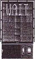
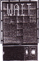
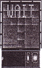
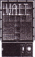 | START-OF-DOCKING The system is started by pressing one of the aircraft type buttons on the operator panel. When the button has been pressed, WAIT will be displayed. |
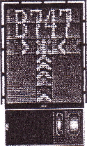 | CAPTURE The floating arrows indicate that the system is activated and in capture mode, searching for an approaching aircraft. If shall be checked that the correct aircraft type is displayed. The lead-in line shall be followed. The pilot must not proceed beyond the bridge, unless the arrows have been superseded by closing rate bar. |
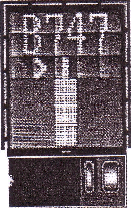 | TRACKING . When the aircraft has been caught by the laser, the floating arrow is replaced by the yellow centre line indicator. A flashing red arrow indicates the direction to turn. The vertical yellow arrow shows position in relation to the centre line. This indicator give correct position and azimuth guidance. |
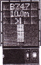 | CLOSING RATE. Display of digital countdown will start when the aircraft is 20 M from stop position. When the aircraft is less than 12 M from the stop position, the closing rate is indicated by turning off one row of the center line symbol per 0.5 M, covered by the aircraft. Thus, when the last row is turned off, 0.5 M remains to stop. |
 | ALIGNED TO CENTRE The aircraft is eight meters from the stop position. The absence of any direction arrow indicates an aircraft on the centre line. |
 | SLOW DOWN If the aircraft is approaching faster than the accepted speed, the system will show SLOW DOWN as a warning to the pilot. |
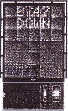
 | AZIMUTH GUIDANCE The aircraft is 4 M from the stop-position. The yellow arrow indicates an aircraft to the right of the centre line, and the red flashing arrow indicates the direction to turn. |
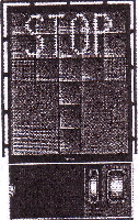
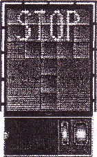
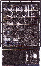
 | STOP POSITION REACHED . When the correct stop-position is reached, the display will show STOP and red lights will be lit. |
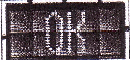
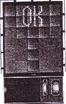 | DOCKING COMPLETE . When the aircraft has parked, OK will be displayed. |
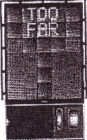 | OVERSHOOT If the aircraft overshoot the stop-position, TOO FAR will be displayed. |
  | STOP SHORT If the aircraft is found standing still but has not reached the intended stop position, the message STOP OK will be shown after a while. |
 | WAIT If some object is blocking the view toward the approaching aircraft or the detected aircraft is lost during docking, before 12 M to STOP, the display will show WAIT. The docking will continue as soon as the blocking object has disappeared or the system detects the aircraft again. As the aircraft is approaching the stop position, the aircraft geometry is being checked. If, for any reason, aircraft verification is not made 12 M before the stop-position, the display will show WAIT, STOP and ID FAIL. The text will be alternating on the upper two row of the display . The pilot must not proceed beyond the bridge, unless the “WAIT” message has been superseded by the closing rate bar. |
 | BAD WEATHER CONDITION During heavy fog, rain or snow, the visibility for the docking system can be reduced. When the system is activated and in capture mode, the display will deactivate the floating arrows and show DOWN GRADE. This message will be superseded by the closing rate bar, as soon as the System detects the approaching aircraft. The pilot must not proceed beyond the bridge, unless the DOWN GRADE text has been superseded by the closing rate bar. |
 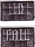 | AIRCRAFT VERIFICATION FAILURE During entry into the stand, the aircraft geometry is being checked. If, for any reason, aircraft verification is not made 40 FT metres before the stop-position, the display will first show WAIT and make a second verification check. If this fails STOP and ID FAIL will be displayed. The text will be alternating on the upper two rows of the display. The pilot must not proceed beyond the bridge without manual guidance, unless the WAIT message has been superseded by the closing rate bar. |
 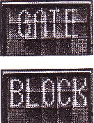 | GATE BLOCKED If an object is found blocking the view from the DGS to the planned stop position for the aircraft, the docking procedure will be halted with a GATE BLOCK message. The docking procedure will resume as soon as the blocking object has been removed. The pilot must not proceed beyond the bridge without manual guidance, unless the WAIT message has been superseded by the closing rate bar. |
 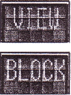 | VIEW BLOCKED If the view towards the approaching aircraft is hindered for instance by dirt on the window, the DGS will report a view block condition. Once the system is able to see the aircraft through the dirt, the message will be replaced with a closing rate display. The pilot must not proceed beyond the bridge without manual guidance, unless the WAIT message has been superseded by the closing rate bar . |
  | SBU-STOP . Any unrecoverable error during the docking procedure will generate an SBU condition. The display will show red stop bar and the text STOP SBU. A manual backup procedure must be used for docking guidance. |
 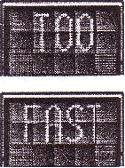 | TOO FAST If the aircraft approaches with a speed higher than the docking system can handle, the message STOP (with red squares) and TOO FAST will be displayed. The docking system must be re-started or docking procedure completed by manual guidance. |
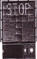
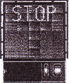 | EMERGENCY STOP . When the emergency stop button is pressed, STOP is displayed. |
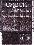 | CHOCKS ON . CHOCK ON will be displayed, when the ground staff has put the chocks in front of the nose wheel and pressed the “Chocks On” button on the operator panel. |
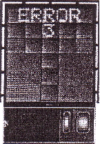 | ERROR . If a system error occurs, the message ERROR is display with an error code. The code is used for maintenance purposes and explained else where. |
 | SYSTEM BREAKDOWN In case of a severe system failure, the display will go black, except for a red stop indicator. A manual backup procedure must be used for docking guidance. POWER FAILURE In case of a power failure, the display will be completely black. A manual backup procedure must be used for docking guidance. |
All aircraft parking bays are allocated by Ground / Apron. Controller with regard to aircraft type involved and the prevailing or anticipated traffic situation.
The marshalling of scheduled, non-scheduled and casual aircraft into the bays either manually or by the aid or the VDGS Guide - in system and the pushing out of aircraft for departure shall be under the responsibility of the aircraft operator or its appointed ground handling agency.
Due to the minimum separation distance between runway centre line and centre line of parallel TWY A and TWY J (military use) are 120 M and 150 M respectively. Taxiway A and J not available to other aircraft when aircraft with code C, D or E take off or landing on the runway, due to the distances between the runway centre line and taxiway centre lines are less than the minimum required.
5. 180 DEGREES TURN ON RUNWAY
To prevent runway pavement damage, all aircraft code letter “C” and higher are not allowed to make 180 degrees turn on Runway.
VTSS AD 2.21 NOISE ABATEMENT PROCEDURES
NIL
VTSS AD 2.22 FLIGHT PROCEDURES
1. LOW VISIBILITY PROCEDURES (LVP)
VTSS AD 2.23 ADDITIONAL INFORMATION
1. Operations of aircraft at Hat Yai International Airport outside Airport’s hours of operation.
Remark: Aircraft below code letter “C” is allowed to seft-maneuver. Inform Hat Yai before seft-maneuver.
VTSS AD 2.24 CHARTS RELATED TO AN AERODROME
|
Chart name |
Page |
|---|---|
|
Aerodrome Chart - ICAO | AD 2-VTSS-2-1 |
|
Aircraft Parking/Docking Chart - ICAO | AD 2-VTSS-2-3 |
|
Aerodrome Ground Movement Chart - ICAO | AD 2-VTSS-2-5 |
|
Aerodrome Obstacle Chart - ICAO Type A - RWY 08/26 | AD 2-VTSS-3-1 |
|
Area Chart - ICAO | AD 2-VTSS-5-1 |
|
Instrument Approach Chart - ICAO - VOR A | AD 2-VTSS-8-1 |
|
Instrument Approach Chart - ICAO - VOR B | AD 2-VTSS-8-3 |
|
Instrument Approach Chart - ICAO - VOR RWY 26 | AD 2-VTSS-8-5 |
|
Instrument Approach Chart - ICAO - ILS or LOC RWY 26 | AD 2-VTSS-8-7 |
|
Instrument Approach Chart - ICAO - RNP RWY 08 | AD 2-VTSS-8-9 |
|
Instrument Approach Chart - ICAO - RNP RWY 08 (Tabular description) | AD 2-VTSS-8-10 |
|
Instrument Approach Chart - ICAO - RNP RWY 26 | AD 2-VTSS-8-11 |
|
Instrument Approach Chart - ICAO - RNP RWY 26 (Tabular description) | AD 2-VTSS-8-12 |